Home & Garden
Freezing Weekend Weather Forecast for Pelham
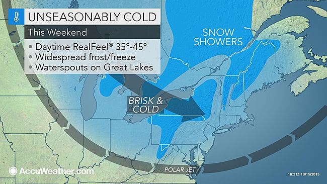
The National Weather Service issued a "Hazardous Weather Outlook" for the area in anticipation of the arrival of the season's coldest air.

Written by BRIAN MCCREADY (Patch Staff)
Well we knew it was inevitable as we’ve reached that point in the calendar where temperatures are going to grow colder each week, and now it’s official.
“We may have a cold, blustery weekend ahead of us,” said Bill Potter of Hudson Valley Weather.
Find out what's happening in Pelhamfor free with the latest updates from Patch.
The National Weather Service has issued a “Hazardous Weather Outlook” for Weschester County in anticipation of the first freeze of the season.
Both along the county’s coastline and northern portions, the first freeze of the season is expected on Sunday night, the NWS predicts.
Find out what's happening in Pelhamfor free with the latest updates from Patch.
Here is the service’s detailed weekend weather forecast:
Today: Mostly sunny. Highs in the mid 60s. West winds 10 to 15 mph.
Tonight: Mostly clear in the evening...then becoming partly cloudy. Lows in the mid 40s. West winds 5 to 10 mph.
Saturday: Mostly sunny. Highs in the mid 50s. Northwest winds 10 to 15 mph with gusts up to 25 mph.
Saturday Night: Mostly clear. Lows in the mid 30s. Northwest winds 10 to 15 mph. Gusts up to 25 mph in the evening.
Sunday: Partly sunny. A slight chance of rain showers in the afternoon. Highs in the upper 40s. Northwest winds 5 to 10 mph. Chance of rain 20 percent.
Sunday Night: Partly cloudy in the evening...then clearing. Lows in the lower 30s.
Monday: Sunny. Highs in the lower 50s.
Have a great weekend.
Patch Editors Lanning Taliaferro and Alfred Branch contributed to this report.
Map via AccuWeather.com
Get more local news delivered straight to your inbox. Sign up for free Patch newsletters and alerts.