Home & Garden
WEATHER UPDATE: New York City, Hudson Valley Area in Possible Path of Hurricane Joaquin
Joaquin, rapidly intensifying in the Atlantic, could arrive in the Metro-NYC area by late this weekend or early next week.

Written by SIMONE WILSON (Patch Staff) and LANNING TALIAFERRO (Patch Staff)
Joaquin reached Category 3 status late Wednesday evening anc could reach category 4 by Thursday night, according to the National Hurricane Center (NHC).
The National Weather Service’s most recent bulletin urges people to follow the news closely to be prepared.
Find out what's happening in Pelhamfor free with the latest updates from Patch.
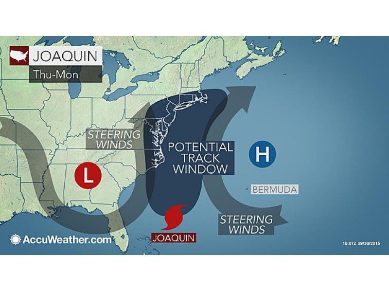
The most likely scenario is for Joaquin to be guided westward this weekend with possible landfall between North Carolina and southern New Jersey on Sunday, according to AccuWeather meteorologists.
“A hurricane watch for a portion of the U.S. coast could be required as early as tonight,” says the NHC.
Find out what's happening in Pelhamfor free with the latest updates from Patch.
A graphic of the hurricane’s projected path, which is being updated constantly by the NHC but is still very uncertain, predicts that the storm could hit the Mid-Atlantic Coast by this weekend — and could make its way to the New York City area by Sunday or Monday.
The Weather Channel places New York City well within its “threat” zone of locations that need to keep a close eye on Joaquin.
However, Eric Holthaus, Slate’s weather reporter, notes that a direct landfall on New York City landfall “hasn’t been consistently showing up in any model.”
Holthaus explains that the current government projection for Joaquin’s path is “merely the NHC’s way of splitting the difference between two very different but roughly equally likely possibilities: A landfall in the Carolinas/Virginia or a track safely out to sea.”
New York Gov. Andrew M. Cuomo yesterday urged New Yorkers to be prepared:
- Know your weather terms – A flash flood “watch” indicates flash flooding or flooding is possible within the designated watch area. When a watch is issued, be alert and ready to take action. A flash flood “warning” means flash flooding or flooding has been reported or is imminent. You should take necessary precautions and actions at once.
- Stock up on emergency supplies, including non-perishable food and water, to last for more than 72 hours or three days.
- Know how to contact all family members at all times. Identify an out-of-town friend or family member to be the “emergency family contact” and make sure all family members know that number.
- Designate a family emergency meeting point – a familiar location where the family can meet in case the home is inaccessible.
- Prepare an emergency phone list of people and organizations that may need to be called, including schools, doctors, child/senior care providers, and insurance agents.
- Know the hurricane / storm risks in your area, including storm surge history.
- Learn about your community’s warning signals and evacuation plans.
- Start thinking about where to relocate your pets during a storm.
- Stock up on prescribed medicines and prepare supplies for persons with special needs such as children, the elderly, and infirm.
- Check on neighbors to ensure they are aware of the potential danger and what they need to do to prepare for the storm.
“Our state has seen the damage that extreme weather can cause time and time again – and I am urging New Yorkers take precautions for more heavy storms in the coming days,” Cuomo said in a prepared statement. “Tropical Storm Lee and Hurricane Irene proved that you do not have to be near the coast to be impacted by Mother Nature. I have directed State agencies to ready their emergency response equipment in partnership with local governments, and I encourage all of our state’s residents to be prepared and stay safe.”
Patch Editor Alfred Branch contributed to this report.
Map via AccuWeather.com
Get more local news delivered straight to your inbox. Sign up for free Patch newsletters and alerts.
