Home & Garden
Weekend Weather: Heavy Rains, Cooler Temperatures
Check out Patch's new weather page for an hour-by-hour forecast.

If you enjoy clouds and heavy rain on a summer weekend, then you’ll love this forecast.
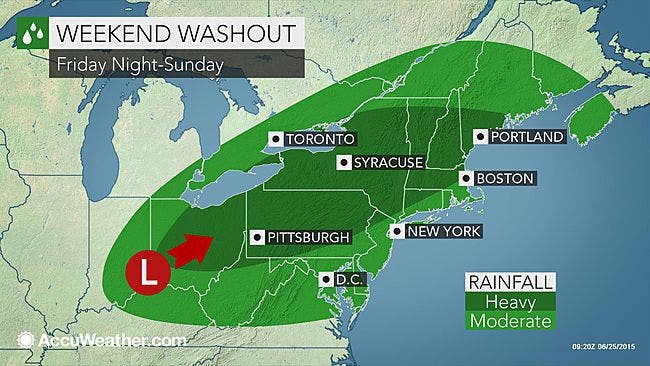
Slow-moving storms are winding their way into the Westchester and Hudson Valley region, which could begin dumping precipitation on Friday, but really kick into gear Saturday evening and Sunday, according to the National Weather Service.
And it doesn’t look like we’ll see any sun all weekend, as the forecast calls for mostly cloudy skies, which will keep temperatures on the cooler side.
Find out what's happening in Pelhamfor free with the latest updates from Patch.
“With the slow-moving nature of this system and its gradual strengthening, heavy rain is inevitable,” says AccuWeather Meteorologist Evan Duffey. “Through Saturday and Sunday, a swath of 1 to 2 inches (25 to 55 mm) will be across the Northeast, with locally higher amounts.”
Before then, today’s weather will remain sunny with highs in the 80s, but a 60 percent chance of rain creeps in late tonight, according to the NWS.
Find out what's happening in Pelhamfor free with the latest updates from Patch.
Friday could begin with rain early in the morning, and then turn to mostly cloudy with highs barely getting into the 70s.
Saturday will be cloudy with rain moving in during the afternoon and evening to soak the region.
Sunday will see more rain, clouds and highs in the mid- to low-70s.
Click here to view the hyperlocal forecast on the Pelham Patch weather page.
Map via AccuWeather.com
Get more local news delivered straight to your inbox. Sign up for free Patch newsletters and alerts.