Weather
As Hurricane Matthew Targets Caribbean, Still Too Soon to Predict Potential Impacts to Long Island
BREAKING: All eyes will be on Hurricane Matthew for the next week as the slow-moving storm makes its way north.

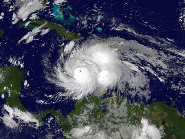
Hurricane Matthew weakened somewhat in the overnight hours, packing winds of 130 mph early Monday morning. Despite a loss in maximum sustained wind power, the storm remains a Category 4 hurricane, and it's expected to cause devastating damage to parts of Cuba, Haiti, Jamaica and the Bahamas over the next few days, according to the National Hurricane Center.
Matthew was located about 220 miles southeast of Kingston, Jamaica, as of the hurricane center’s 8 a.m. Monday report. The storm was moving north at 6 mph, a slight increase in forward movement from Sunday.
On its current projected path, Matthew is expected to near Jamaica and southwest Haiti overnight Monday. The storm is anticipated to clear Cuba on Tuesday before moving into the Atlantic Ocean. Just where Matthew will go after Cuba is somewhat uncertain. The storm is expected to pass offshore of Florida’s east coast at some point on Friday on a course that may bring it into contact with South Carolina or North Carolina over the weekend.
Find out what's happening in Sayville-Bayportfor free with the latest updates from Patch.
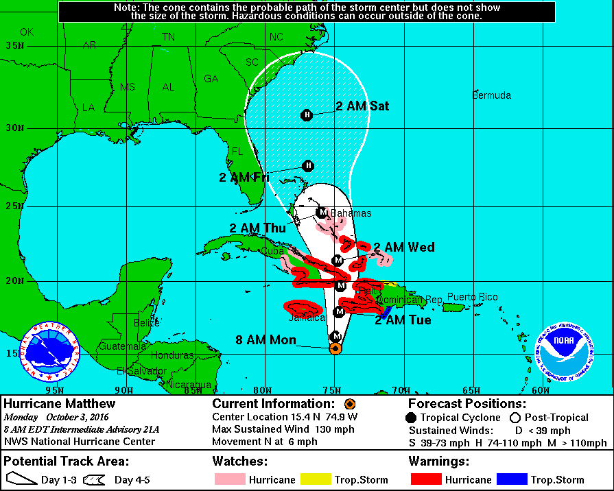
As of Monday morning, hurricane-force winds were extending out from Matthew up to 30 miles. Tropical storm-force winds extended out 195 miles. The system is “expected to remain a powerful hurricane though early Wednesday,” hurricane center forecasters noted in Monday morning’s Tropical Weather Outlook report.
"Although the official forecast continues to show a track east of Florida, it is still too soon to rule out possible hurricane impacts there," the NHC says. "It is also too soon to know whether, or how, Matthew might affect the remainder of the United States east coast."
Find out what's happening in Sayville-Bayportfor free with the latest updates from Patch.
Hurricane Matthew tracking due north up the 75 deg East longitude line. Jamaica, Haiti, Cuba... Prepare for the worst, hope for the best. pic.twitter.com/lvBvPssJQg
— Michael Ventrice (@MJVentrice) October 3, 2016
Long Island meteorologist Joe Cioffi says the current "longer term weather models for the East Coast seem to be in good agreement that Matthew will stay offshore. The GFS is still the furthest left of all the models with the European the furthest to the right. I'm beginning to think that we are going to see Hurricane Matthew stay offshore but the only question in my mind is whether it tracks close enough to give us some much needed rain as the GFS implies."
If Long Island is impacted by Matthew, those impacts will not be felt until the weekend. Besides a chance of showers and thunderstorms Monday, the workweek on Long Island is expected to be dry with daily highs between 65-70 degrees each day.
Graphics courtesy of NOAA
Sherri Lonon contributed to this report.
Get more local news delivered straight to your inbox. Sign up for free Patch newsletters and alerts.