Community Corner
Arctic April: Freezing Temperatures, Snow, 60 MPH Winds Possible on Long Island
A hazardous weather outlook has been issued for Long Island.

March is going out as a lamb, but April apparently plans to come in like February.
The National Weather Service has issued the following hazardous weather outlook for Long Island:
"A strong cold front passage Saturday evening will bring unseasonably cold air to the region on very strong northwesterly winds. Wind gusts behind the front of 50 to 60 mph are possible Saturday night into Sunday morning. Winds of these magnitudes can be damaging and lead to power outages."
The first two days of April will feature seasonable temperatures, but then the bottom drops out.
Highs on Sunday, Monday and Tuesday will only be in the low-to-mid 40s, the National Weather Service says. And the mercury will likely drop below freezing on Sunday and Monday nights.
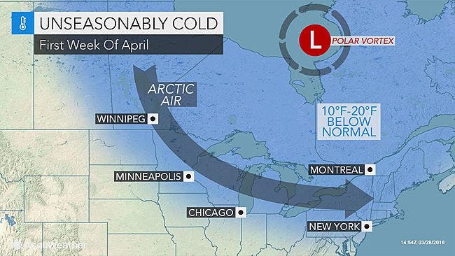
"Temperatures in the Northeast will be 10-20 degrees Fahrenheit below normal, which will be the largest negative anomalies since Valentine's Day," AccuWeather Meteorologist Joe Lundberg said. "When the wind is factored in, it will feel a whopping 40-60 degrees colder than it will late this week."
Rain is expected to mix with snow early Sunday morning on Long Island. Monday night and Tuesday will also bring a chance of snow showers. No accumulations are currently expected.
Here's the full forecast:
Wednesday- Sunny, with a high near 50. Southwest wind 8 to 13 mph.
Wednesday Night- Partly cloudy, with a low around 39. Southwest wind 11 to 15 mph.
Thursday- Mostly sunny, with a high near 59. Breezy, with a south wind 15 to 21 mph, with gusts as high as 37 mph.
Thursday Night- Rain and possibly a thunderstorm, mainly after 3am. Steady temperature around 55. Breezy, with a south wind 18 to 21 mph, with gusts as high as 31 mph. Chance of precipitation is 80%. New rainfall amounts between a quarter and half of an inch possible.
Friday- Rain and possibly a thunderstorm before 3pm, then rain likely. High near 57. Breezy, with a south wind 18 to 21 mph. Chance of precipitation is 80%. New rainfall amounts between a half and three quarters of an inch possible.
Friday Night- A chance of showers before midnight. Mostly cloudy, with a low around 42. Chance of precipitation is 30%.
Saturday- Partly sunny, with a high near 51.Saturday NightA chance of rain showers after midnight, mixing with snow after 3am. Partly cloudy, with a low around 34. Breezy. Chance of precipitation is 30%.
Sunday- Mostly sunny, with a high near 41. Windy.
Sunday Night- Mostly clear, with a low around 26. Blustery.
Monday- Mostly sunny, with a high near 41.
Monday Night- A chance of snow showers. Mostly cloudy, with a low around 30. Chance of precipitation is 30%.
Tuesday- A chance of rain and snow showers. Partly sunny, with a high near 42. Chance of precipitation is 40%.
Photo: AccuWeather
Get more local news delivered straight to your inbox. Sign up for free Patch newsletters and alerts.