Community Corner
Winter Storm Set to Hit Long Island This Weekend
The latest snowfall predictions for the region.

An intense, but quick moving winter storm will bring snow to Long Island on Saturday, according to the National Weather Service.
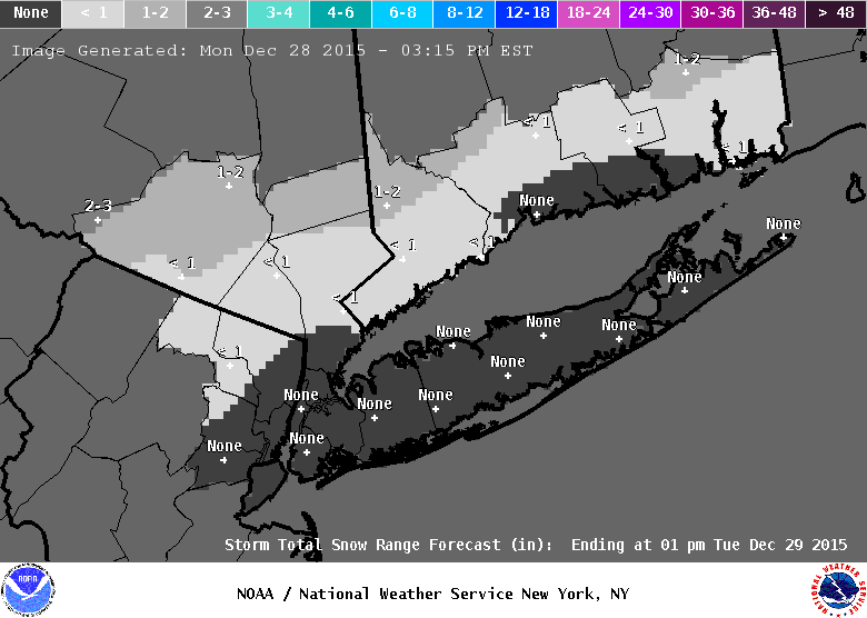
The latest snow projections are on the decline, with 1-4 inches now expected to fall across the island.
A hazardous weather outlook remains in effect with a low pressure system set to emerge from the Gulf of Mexico Friday night and then track northeast along the East Coast on Saturday, the NWS says. The system will pass south and east of Long Island Saturday evening.
Find out what's happening in Southamptonfor free with the latest updates from Patch.
- Sign up for weather and breaking news alerts from Patch here
“There is still some uncertainty with the precipitation type and amounts due to the storm track and intensity,” according to the hazardous weather outlook.
Much of the snow from the storm may be on the front end of Saturday morning, the NWS says. The East End of Long Island will likely see the lowest snowfall amounts, between 1-2 inches. The North Shore in Nassau could get 3-4 inches.
Find out what's happening in Southamptonfor free with the latest updates from Patch.
The wind will also pick up on Saturday afternoon and peak in the evening with wind gusts in the 30s for much of the island, the NWS says.
A period of heavy rain late Saturday morning into Saturday afternoon may also cause ”some nuisance flooding issues” across the eastern part of the island, the NWS says. A wintry mix of rain, snow and sleet in the afternoon may turn back to all snow Saturday night.
More on Patch:
- Filming in Huntington: Tina Fey, Amy Poehler Comedy
- Police: Drunk Hauppauge Woman Crashes Into House With Daughter in Car
- Hicksville Grad Drafted to Play Professional Soccer
- Police: N. Bellmore Man Dies in Upstate Accident
- Medford Boy Honored For Helping to Save Family, Neighbors From Fire
- DA: Flavor Flav Indicted on Speeding, Suspended License
- Cops: Body of Missing Hicksville Teen Found
- Long Beach Swimmer to Try for 2016 Olympics
- Police Seek Suspect in Medford Home Invasion
Get more local news delivered straight to your inbox. Sign up for free Patch newsletters and alerts.