HUDSON VALLEY, NY — Predictions are firming up about the chance of accumulating snow across the Hudson Valley Thursday night into Friday.
The forecast is still uncertain.
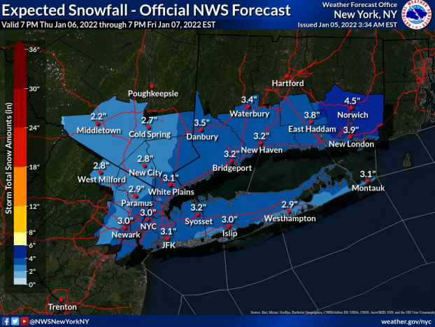
"Early projections would give our region between 2 and 6 inches of snow, depending on how the details unfold in the next 24 to 36 hours," Alex Marra and Bill Potter at Hudson Valley Weather said Wednesday before they began concentrating on the widespread ice storm. "If the upper level trough is stronger and deeper, it could mean a storm that hugs the coast and intensifies. These little details in the setup can create big changes in the end result… so we’ll be watching closely."
Find out what's happening in Southeast-Brewsterfor free with the latest updates from Patch.
The NWS is also hedging its bets, saying a weaker and/or farther offshore low would result in light snow accumulation, while if the storm is stronger and/or tracks closer to the coast, that would increase the potential for "warning level" snowfall.
Find out what's happening in Southeast-Brewsterfor free with the latest updates from Patch.
Any accumulation could result in hazardous travel, especially for the Friday morning commute, the NWS warned.
Get more local news delivered straight to your inbox. Sign up for free Patch newsletters and alerts.