Weather
Prep For Severe Storms, Damaging Winds: Hudson Valley Update
Utility companies are mobilizing their emergency response teams. Here are safety tips for severe weather.

HUDSON VALLEY, NY — A severe weather system is forecast to sweep across New York through Monday evening with heavy rain and flash flooding, dangerous lightning, damaging hail, wind gusts up to 60 mph which could down trees and power lines, and even isolated tornadoes.
It's four years ago exactly that a similar set of storms brought tornadoes, macro- and microbursts to the Hudson Valley and left much of the region without power.
"The precise impacts will vary due to location. One town could see a high-impact severe storm with down trees and power lines ... while a town 5 miles away could have a low-impact gusty non-severe T-Storm," Alex Marra and Bill Potter of Hudson Valley Weather said on Facebook. "So be sure to prepare for the potential of a severe storm, and the possibility of losing power for several hours."
Find out what's happening in Southeast-Brewsterfor free with the latest updates from Patch.
Based on the forecast, preparations have begun across the Hudson Valley.
- Utility companies are mobilizing emergency responses to repair damage and restore electric service interruptions.
- MTA Bridges and Tunnels will implement a ban on empty tractor-trailers and tandem trucks from 2 p.m. through 10 p.m.
- Ossining has canceled all afterschool activities
- Red Hook schools dismissed students early.
- Putnam Closing Early, Stopping Transportation Before Storms
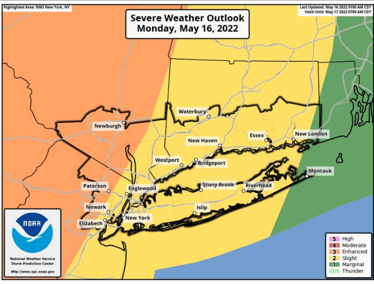
The mid-Hudson Valley has the highest chance of the most severe weather (the band in orange is ranked "enhanced"):
Find out what's happening in Southeast-Brewsterfor free with the latest updates from Patch.
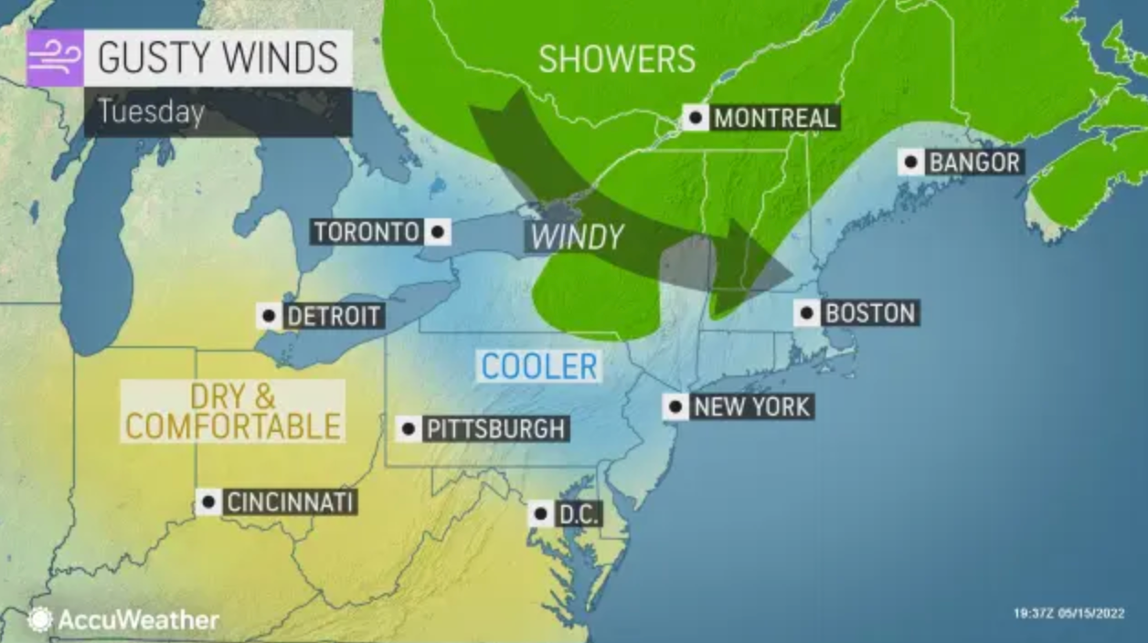
The cold front will move through the mid-Atlantic into the Northeast.
"More than 60 million are at risk for some form of severe weather impacts on Monday as the storms are expected to target densely populated metro areas," said Mary Gilbert, AccuWeather meteorologist.
The National Weather Service said they could bring:
- Damaging Wind: Wind gusts in excess of 58 mph could damage trees and power lines and result in scattered power outages.
- Heavy Rainfall: Marginal flash flood risk, localized flooding of urban, poor drainage areas, quick responding small streams and creeks possible.
- Large Hail: 1 inch hail could result in minor damage to motor vehicles.
- Tornadoes: An isolated tornado possible.
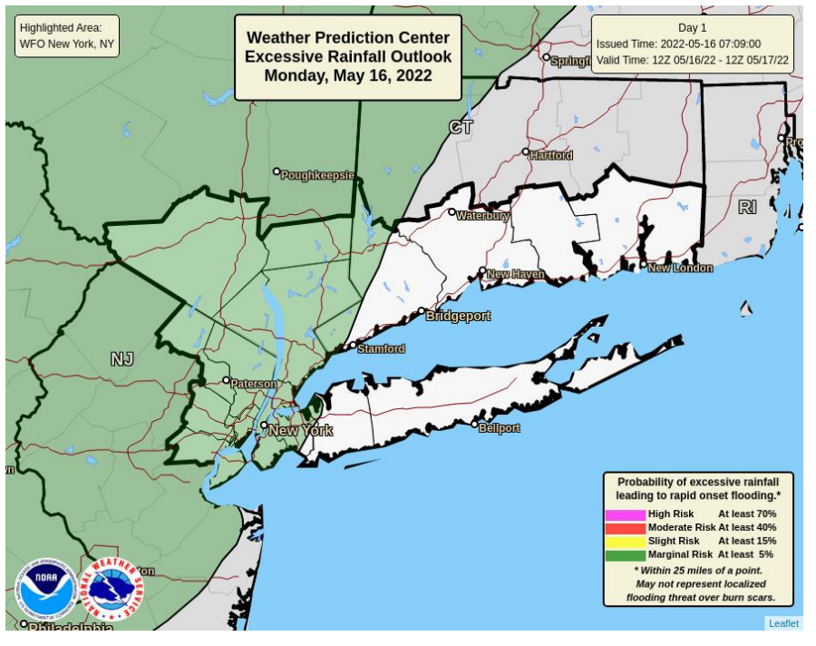
The entire region can expect high amounts of rain:
For Dutchess and Ulster counties, the main threat will be damaging wind gusts, although isolated occurrences of large hail are also possible. Thunderstorms may also produce downpours which could result in localized flooding of urban, poor drainage and low lying areas.
For Orange, Putnam, Rockland and Westchester: Damaging winds, large hail and an isolated tornado may also be possible.
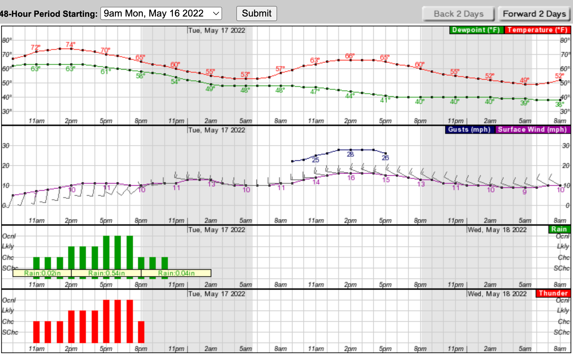
Here's an hour-by-hour look at the next 24 hours, based on Putnam County:
After the cold front moves through, the easing of temperatures and humidity will make conditions feel more like spring again for a few days; however, Gilbert said, "AccuWeather forecasters caution that this round of more comfortable weather may not be around to stay for very long as another pattern change is on the horizon."
Gov. Kathy Hochul urged New Yorkers to use caution and stay alert throughout the day for rapidly changing conditions.
Severe Weather Safety Tips
Preparedness
- Learn the safest route from your home or business to high, safe ground should you have to leave in a hurry.
- Develop and practice a 'family escape' plan and identify a meeting place if family members become separated.
- Make an itemized list of all valuables including furnishings, clothing and other personal property. Keep the list in a safe place.
- Stockpile emergency supplies of canned food, medicine and first aid supplies and drinking water. Store drinking water in clean, closed containers.
- Plan what to do with your pets.
- Have a portable radio, flashlights, extra batteries, and emergency cooking equipment available.
- Keep your vehicle fueled or charged. If electric power is cut off, gasoline stations may not be able to pump fuel for several days. Have a small disaster supply kit in the trunk of your car.
- Have disaster supplies on hand, including: flashlights and extra batteries, battery-operated radio and extra batteries, first aid kit and manual, emergency food and water, non-electric can opener, essential medicines, checkbook, cash, credit cards, ATM cards
Flash Flooding
- Never attempt to drive on a flooded road. Turn around and go another way.
- If water begins to rise rapidly around you in your car, abandon the vehicle immediately.
- Do not underestimate the power of fast-moving water. Two feet of fast-moving flood water will float your car, and water moving at two miles per hour can sweep cars off a road or bridge.
Lightning
- Follow the 30-30 rule: If the time between when you see a flash of lightning and hear thunder is 30 seconds or less, the lightning is close enough to hit you. Seek shelter immediately. After the last flash of lightning, wait 30 minutes before leaving your shelter.
- Lightning hits the tallest object. If you are above a tree line, quickly get below it and crouch down if you are in an exposed area.
- If you can't get to a shelter, stay away from trees. If there is no shelter, crouch in the open, keeping twice as far away from a tree as it is tall.
Tornado
- If outdoors and a Tornado Warning is issued, seek shelter immediately. If there is no shelter nearby, lie flat in a ditch or low spot with your hands shielding your head.
- If at home or in a small building, go to the basement or an interior room on the lowest floor of the building. Stay away from windows. Closets, bathrooms, and other interior rooms offer the best protection. Get under something sturdy or cover yourself with a mattress.
- If in a school, hospital, or shopping center, go to a pre-designated shelter area. Stay away from large open areas and windows. Do not go outside to your car.
- If in a high-rise building, go to an interior small room or hallway on the lowest floor possible. Do not use elevators - use stairs instead.
For more safety tips, visit the New York State Division of Homeland Security and Emergency Services Safety Tips web page.
Check back with Patch for updates. Sign up for Patch news alerts to get weather updates straight to your inbox.
Get more local news delivered straight to your inbox. Sign up for free Patch newsletters and alerts.


