Home & Garden
More Winter Coming for Brewster, Southeast: Work Week Weather
It's going to be a cold couple of days.

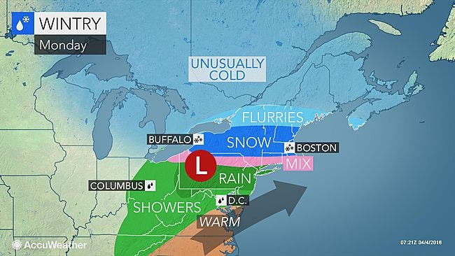
The latest storm brought more snow Monday morning, causing some school districts in the Hudson Valley to delay opening for a couple of hours.
Quite a contrast, eh? On Friday in Poughkeepsie the high was 78 degrees and 36 hours later, it was 33 degrees, Hudson Valley Weather pointed out.
The arctic chill that set in Saturday will continue for the next few days. That plus rain, sleet and snow on Monday could make for a tricky Tuesday commute.
Find out what's happening in Southeast-Brewsterfor free with the latest updates from Patch.
"Plunging temperatures Monday night will cause any wet or slushy areas on untreated roads and sidewalks in New England or southern New England to freeze," AccuWeather Senior Meteorologist Kristina Pydynowski said.
While the snow chances end for at least now, Mother Nature is keeping a lid on temperatures this week. It’s going to feel like winter several days this week, and we could drop into the teens late Tuesday.
Find out what's happening in Southeast-Brewsterfor free with the latest updates from Patch.
Want hour to hour info: Click here for Brewster and Southeast’s in-depth weather forecast.
Here's what the National Weather Service says for the work week in Putnam County:
- Today-Rain. Snow with a chance of sleet early this morning. Total snow accumulation around an inch. Highs in the lower 40s. East winds 5 to 10 mph...becoming northeast this afternoon. Chance of precipitation 90 percent.
- Tonight-Mostly cloudy with snow likely with pockets of rain and freezing rain in the evening...then partly cloudy with a slight chance of snow after midnight. Cold with lows around 20. North winds around 10 mph. Chance of precipitation 80 percent.
- Tuesday-Sunny. Cold with highs in the mid 30s. North winds 10 to 15 mph.
- Tuesday Night-Mostly clear. Cold with lows around 17. Northwest winds 5 to 10 mph.
- Wednesday-Partly sunny. Highs in the mid 40s. South winds 10 to 15 mph. Gusts up to 25 mph in the afternoon.Wednesday NightMostly cloudy. A chance of rain in the evening...then showers likely after midnight. Not as cool with lows in the upper 30s. Chance of rain 60 percent.
- Thursday-Showers likely. Highs in the upper 50s. Chance of rain 70 percent.
- Thursday Night-Cloudy. Showers likely...mainly in the evening. Lows in the upper 30s. Chance of rain 60 percent.
- Friday-Mostly cloudy. Highs in the upper 40s.
- Friday Night-Mostly cloudy. Cold with lows in the upper 20s.
Photo credit: Accuweather.com
Get more local news delivered straight to your inbox. Sign up for free Patch newsletters and alerts.