Community Corner
'Near Blizzard Conditions,' Gusting Winds Expected This Weekend
Driving could be hazardous in Southeast

The National Weather Service has issued Winter Weather Advisories and Hazardous Weather Outlooks for Putnam, Rockland and Westchester counties from noon on Valentine’s Day to 1 p.m. Feb. 15.
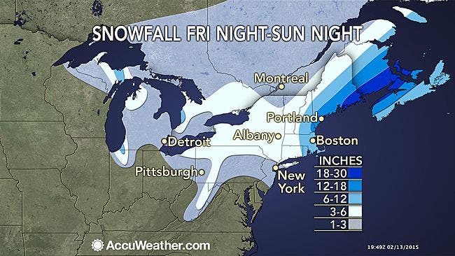
The prediction is 3-7 inches of snow—and near blizzard conditions at times Saturday night.
Snow will start off light Saturday afternoon, along with a blast of arctic air. It will become heavy at times before tapering off Sunday afternoon. Considerable blowing and drifting snow with near blizzard conditions is possible Saturday night into Sunday morning as winds increase.
Find out what's happening in Southeast-Brewsterfor free with the latest updates from Patch.
Impacts: dangerous travel due to snow and strong winds with near blizzard conditions possible. Strong winds may down power lines and tree limbs.
Those winds and plummeting temperatures caused by the strengthening storm will make for dangerous conditions to be outdoors throughout the Northeast, says Alex Sosnowski, AccuWeather.com Senior Meteorologist.
Find out what's happening in Southeast-Brewsterfor free with the latest updates from Patch.
Still, we’ll probably dodge another bullet.
“A close call for the Hudson Valley, but it appears that the deep intensification of this storm will occur about 6 to 12 hours too late,” says Hudson Valley Weather. “The worst impacts of this storm (heavy snows and blizzard conditions), will be confined to New England, and possibly Boston yet again.”
Here’s the local forecast for Brewster:
- Tonight-Increasing clouds, with a low around -1. Northwest wind around 5 mph becoming calm in the evening.
- Saturday-Snow, mainly after 1pm. High near 28. Wind chill values between zero and 10. Calm wind becoming south 5 to 9 mph in the morning. Chance of precipitation is 80%. New snow accumulation of 1 to 2 inches possible.
- Saturday Night-Snow. Low around 12. Wind chill values between zero and 10. Light and variable wind becoming northwest 10 to 15 mph in the evening. Chance of precipitation is 90%. New snow accumulation of 2 to 4 inches possible.
- Sunday-A chance of snow, mainly before 11am. Mostly cloudy and cold, with a temperature falling to around 10 by 5pm. Wind chill values between -10 and zero. Blustery, with a northwest wind 18 to 23 mph, with gusts as high as 39 mph. Chance of precipitation is 50%.
- Sunday Night-Mostly clear, with a low around -4. Blustery, with a northwest wind 16 to 21 mph, with gusts as high as 34 mph.
- Washington’s Birthday-Sunny and cold, with a high near 15.
- Monday Night-Partly cloudy, with a low around 1.
MAP: accuweather.com
Get more local news delivered straight to your inbox. Sign up for free Patch newsletters and alerts.