Home & Garden
Snow to Overspread Lower Hudson Valley Monday
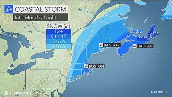
The area is on the edge of a huge storm bearing down on Long Island and Connecticut.

Another round of snow—or the possibility of snow—is facing the lower Hudson Valley.
Rockland and Putnam counties were put under Winter Weather Advisories early Monday morning.
Those counties along with Westchester are under Winter Weather Advisories until 6 p.m. Monday.
Find out what's happening in Southeast-Brewsterfor free with the latest updates from Patch.
The area is on the edge of what Hudson Valley Weather’s meteorologist Bill Potter calls “a monstrous coastal storm.”
He said thanks to a strong upper level low pressure system that is dropping in from the Great Lakes.
Find out what's happening in Southeast-Brewsterfor free with the latest updates from Patch.
The big storm is being pushed out to sea and will only graze the Hudson Valley Monday, Potter said.
Taking all that into consideration, the National Weather Service is calling for snow to begin between 8 a.m. and 9 a.m. and last until around 1 p.m.
Accumulations for this round of snow—yes, there’s more in the forecast through Thursday—is expected to be between 2 and 4 inches.
Temperatures will fall for most areas to the upper 20s or low 30s by the afternoon. However winds will make it feel 20 to 25 degrees.
Map: Accuweather.com.
Get more local news delivered straight to your inbox. Sign up for free Patch newsletters and alerts.