Community Corner
Situation Normal: Snow, Rain and Sleet
Expect flooding then a blast of arctic air to freeze all the slush in Southeast, Tuesday through Thursday.

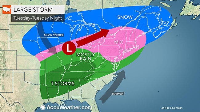
Tuesday through Thursday this week are looking stormy. From 2-6 inches of snow are possible, but that’s just the beginning.
The National Weather Service has issued an Advisory (and an Outlook):
- Winter Weather Advisory in effect from March 3, 03:00 PM EST until March 4, 10:00 AM EST
- Hazardous Weather Outlook is in effect
“Motorists, pedestrians and property owners from the Ohio Valley to southern New England should be prepared for minor flooding as rising temperatures cause snow and ice to change to rain and existing snow cover to turn to slush and water,” says AccuWeather.com Senior Meteorologist Alex Sosnowski.
Find out what's happening in Southeast-Brewsterfor free with the latest updates from Patch.
Low-lying areas and places where piles of snow are covering storm drains will be most susceptible.
Then a new blast of arctic air will turn all the slush to ice.
Find out what's happening in Southeast-Brewsterfor free with the latest updates from Patch.
Here’s the forecast for Brewster:
- Tuesday-Snow likely, mainly after 5pm. Increasing clouds, with a high near 27. Wind chill values between 10 and 20. Calm wind becoming south around 6 mph in the afternoon. Chance of precipitation is 60%. New snow accumulation of less than one inch possible.
- Tuesday Night-Snow, freezing rain, and sleet, becoming all freezing rain after 2am. Temperature rising to around 32 by midnight. Wind chill values between 20 and 25. South wind 6 to 8 mph. Chance of precipitation is 100%. New ice accumulation of less than a 0.1 of an inch possible. New snow and sleet accumulation of 1 to 3 inches possible.
- Wednesday-A chance of freezing rain before 9am, then a chance of rain. Cloudy, with a high near 37. Wind chill values between 25 and 30. West wind 5 to 7 mph. Chance of precipitation is 50%.
- Wednesday Night-Rain likely before 10pm, then snow likely. Cloudy, with a low around 24. West wind 5 to 7 mph becoming northwest after midnight. Chance of precipitation is 60%. New snow accumulation of 1 to 3 inches possible.
- Thursday-Snow likely, mainly before 9am. Cloudy, with a temperature falling to around 22 by 5pm. Chance of precipitation is 60%. New snow accumulation of 2 to 4 inches possible.
- Thursday Night-Mostly clear, with a low around 5.
Get more local news delivered straight to your inbox. Sign up for free Patch newsletters and alerts.