Community Corner
Driving Ban, State of Emergency Lifted: Southeast Storm Central, Jan. 27
Power, parking, shoveling, shopping—find news and info here through the blizzard.

Here’s what you need to know—most recent forecast, safety tips at home and on the road, what to do if the power goes out and more.
Jan. 27
Putnam County has lifted its State of Emergency.
Find out what's happening in Southeast-Brewsterfor free with the latest updates from Patch.
------------------------------------------------------
Jan. 26
Find out what's happening in Southeast-Brewsterfor free with the latest updates from Patch.
Government:
- Gov. Cuomo Imposes Total Driving Ban After 11 p.m.
- Brewster Declares State of Emergency; Will Effect Parking
- Gov. Cuomo Declares State of Emergency for Putnam, Rockland, Westchester
Brewster Trash: Due to the impending blizzard, Suburban Carting will be picking up the garbage in the village Wednesday and Friday this week.
Schools: Brewster schools are closed Jan. 27
Be Prepared: Get your home prepped before the snow starts, advises the Red Cross. Have enough water for three days for each person, check your flashlights and foodstuffs. Learn more:
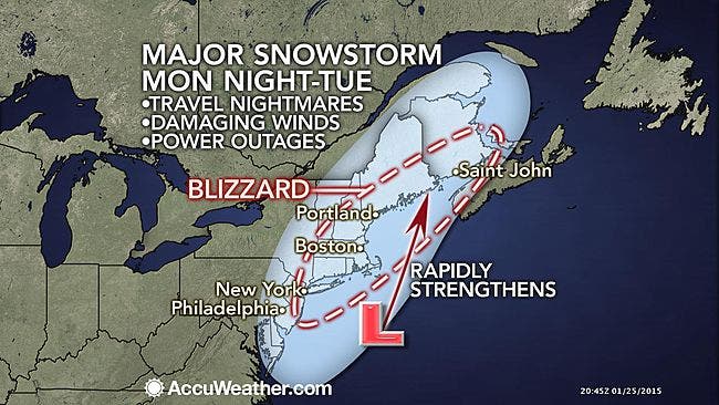
Travel: Gov. Andrew Cuomo warns that I-84, Metro North and the Thruway may close Monday. Flight cancellations will rapidly mount on Tuesday with airports likely forced to close for a time on Tuesday from New York City northward, say accuweather.com meteorologists.
Don’t drive unless it’s absolutely necessary, New York State Police say. If you do, carry food, water and warm blankets as well as a shovel, road salt, a flashlight. For road conditions, traffic, travel and transit info, use http://511ny.org/ or call 511.
- Travel Tips from the State Police, Jan. 26, 27
- Trains, Planes and Buses: Transportation Schedule Changes
- Cuomo: Metro North, Thruway, I-84 May Shut Down Before Monday Evening
Power Problems:
- If your electricity service is interrupted, report it to NYSEG online. You can also call 1-800-572-1131. Get restoration updates online by viewing the NYSEG outage map or outage list.
Local Forecast as of 6:39PM Jan. 26:
- Tonight-Snow with widespread blowing snow. The snow could be heavy at times. Some thunder is also possible. Low around 19. Wind chill values between 5 and 10. North wind 14 to 18 mph, with gusts as high as 32 mph. Chance of precipitation is 100%. Total nighttime snow accumulation of 10 to 14 inches possible.
- Tuesday-Snow with widespread blowing snow. The snow could be heavy at times. Some thunder is also possible. High near 24. Wind chill values between 5 and 10. North wind 13 to 18 mph, with gusts as high as 32 mph. Chance of precipitation is 100%. New snow accumulation of 6 to 10 inches possible.
- Tuesday Night-Light snow, mainly before 9pm. Low around 13. Wind chill values between zero and 10. Northwest wind 10 to 15 mph, with gusts as high as 29 mph. Chance of precipitation is 80%. New snow accumulation of around an inch possible.
- Wednesday-Mostly cloudy, then gradually becoming sunny, with a high near 22. Wind chill values between zero and 10. Northwest wind 10 to 13 mph.
MAP: accuweather.com
» News Alerts: Subscribe to a free email newsletter:
BEDFORD-KATONAH • BRONXVILLE-EASTCHESTER-TUCKAHOE • CHAPPAQUA-MOUNT KISCO • HARRISON • LARCHMONT-MAMARONECK • NANUET • NEW CITY • NEW ROCHELLE • NYACK-PIERMONT • OSSINING-CROTON • PEARL RIVER • PEEKSKILL-CORTLANDT • PELHAM • PORT CHESTER • PLEASANTVILLE-BRIARCLIFF • RIVERTOWNS • RYE • SCARSDALE • SOUTHEAST-BREWSTER • TARRYTOWN-SLEEPY HOLLOW • WHITE PLAINS • YORKTOWN-SOMERS
Get more local news delivered straight to your inbox. Sign up for free Patch newsletters and alerts.