Weather
Stifling Heat In The HV: End Is Near, Flooding May Be The Price
The heat index could hit 100 again across the Hudson Valley before thunderstorms bring relief. Here's the latest.

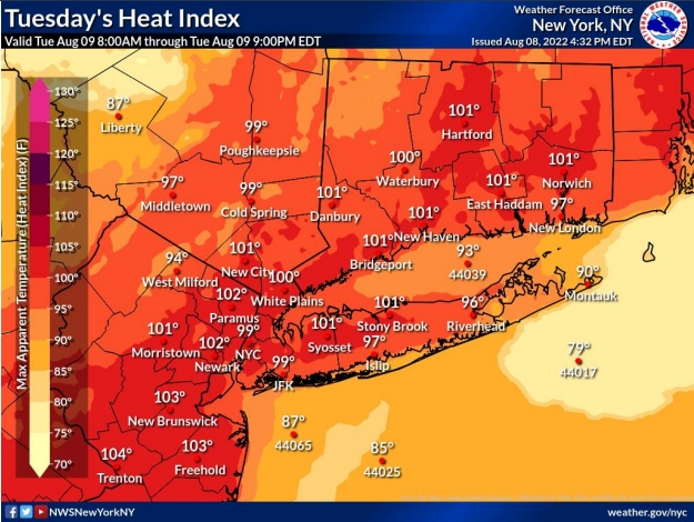
HUDSON VALLEY, NY — Heat advisories remain in effect through 8 p.m. Tuesday, then the region faces a threat of flash flooding and severe weather into Wednesday, the National Weather Service said.
There's a chance of showers and thunderstorms between 11 a.m. and 2 p.m., then showers are likely and possibly thunderstorms in the afternoon. Storms could produce heavy rain.
Rainy or not, Tuesday night will offer little relief from the heat due to high humidity and 'lows' in the middle to upper 70s for much of the NYC metropolitan area.
Find out what's happening in Southeast-Brewsterfor free with the latest updates from Patch.
"For perspective - some locations last night only dropped into the mid 70’s and low 80’s for their low temps," Alex Marra and Bill Potter of Hudson Valley Weather said Tuesday morning.
However, on Wednesday, temperatures drop into the 80s, and nighttime temps will drop into the low 60s. Those conditions will stay through the end of the week.
Find out what's happening in Southeast-Brewsterfor free with the latest updates from Patch.
"Folks planning to watch the peak of the Perseid meteor shower on Thursday night might need a blanket or sweatshirt due to the cooler overnight conditions compared to the recent mild and muggy summer nights," said Alyssa Smithmyer, AccuWeather Meteorologist.
.jpg)
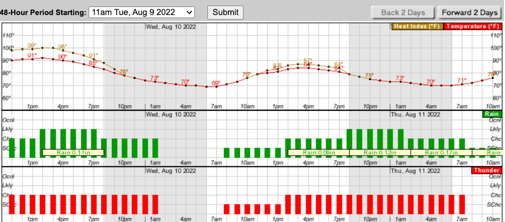
Here's a look at the next 48 hours from the NWS:
Get more local news delivered straight to your inbox. Sign up for free Patch newsletters and alerts.


