Weather
Storm Bringing Snow, Sleet, Up To 3 Inches Of Rain To Hudson Valley
Winter weather advisories have been issued for all but southern Westchester County, where coastal flooding is expected.

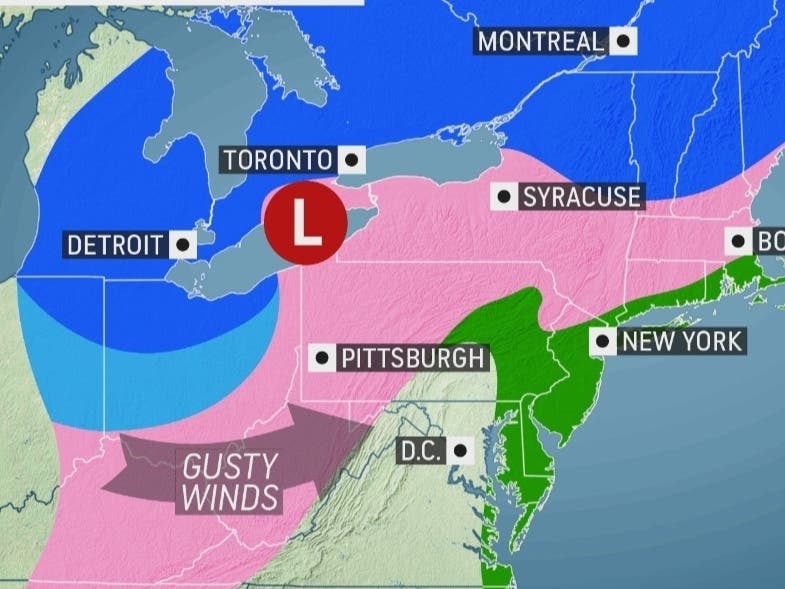
HUDSON VALLEY, NY — Wednesday's storm will bring a wintry mix to the interior Hudson Valley including a lot of rain before ending Thursday, the National Weather Service predicted.
Many school districts there are closed or will dismiss students early. SEE: Hudson Valley Schools Announce Closings, Early Dismissal Due To Storm
Winter weather advisories have been issued for all but southern Westchester County. Snow and mixed precipitation is expected across the region with total snow accumulations of 1 to 5 inches and ice accumulations of a light glaze. Snowfall could be heavy at times, limiting visibility and creating poor road conditions. Winds gusting as high as 40 mph.
Find out what's happening in Southeast-Brewsterfor free with the latest updates from Patch.
The highest snowfall amounts are expected for Orange County.
The timing of the transition from snow to sleet to rain from south to north on Wednesday afternoon and evening will effect how much snow accumulates temporarily.
Find out what's happening in Southeast-Brewsterfor free with the latest updates from Patch.
"Bands of moderate to heavy snowfall will impact most of the region through the afternoon commute," Alex Marra of Hudson Valley Weather said Wednesday morning on Facebook. "Our southernmost parts of Rockland and Westchester may only see a brief burst of snow at the onset before changing over."
One to two inches of rain are expected but up to three inches could fall in some locations. The heaviest rain is expected to fall between 6 p.m. and 2 a.m., the National Weather Service said.
Moderate coastal flooding is likely for coastal Westchester in vulnerable areas near the waterfront and shoreline, including roads, parking lots, and homes and businesses with basements near the waterfront. Road closures are likely, and vehicles parked in vulnerable areas near the waterfront will likely become flooded.
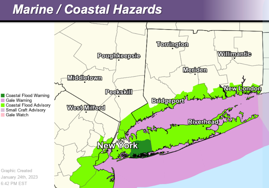
Minor urban and poor drainage flooding is likely, and small river and stream flooding is possible in the lower Hudson Valley.
Strong winds will blow down scattered tree limbs and blow around unsecured objects. Gale conditions are expected on all waters Wednesday evening through Thursday afternoon.
Upstate New York will be hit with colder air and get all snow.
"Not only will colder air be in place as the storm gets underway from Chicago and Detroit to Syracuse and Albany, New York, allowing snow to accumulate faster, but the colder air will also stay put throughout the storm’s duration, meaning that precipitation will remain as snow throughout the entirety of the storm," said Courtney Travis, AccuWeather senior meteorologist.
Here's a look at the next 48 hours from the National Weather Service, based on Putnam County:

Get more local news delivered straight to your inbox. Sign up for free Patch newsletters and alerts.


