Community Corner
Weather Alert: Hazardous Weather Outlook Saturday for Brewster, Southeast
Forecasters predict a significant snow or ice storm—but warn to expect changes in the forecast between now and the weekend.

While there is still much uncertainty, the National Weather Service has issued a Hazardous Weather Outlook for Saturday and Saturday night.
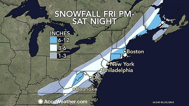
“Unlike many storms this winter, this particular one has the potential to bring a foot of snow to some locations, where rain fails to mix in,” said AccuWeather.com Chief Meteorologist Elliot Abrams.
Whether the storm will bring snow or ice—and how much—is still unknown, the NWS said at 4AM in its most recent update.
Find out what's happening in Southeast-Brewsterfor free with the latest updates from Patch.
NWS models show a rapidly deepening coastal low tracking northeast along the Eastern Seaboard on Saturday. Meteorologists predict it will pass south and east of Long Island on Saturday evening.
“This will be a fast moving system with the potential for significant snow and ice,” said the NWS in its latest Outlook.
Find out what's happening in Southeast-Brewsterfor free with the latest updates from Patch.
- For updates on this storm and other news, subscribe to the Southeast-Brewster newsletter.
Hudson Valley Weather pointed out that the storm is still a couple of days away. Even small shifts in its track could mean big changes in the amount of snow, rain or ice it dumps on Putnam, Rockland and Westchester counties.
“We still have a a lot of time for minor corrections in the track to occur and there will likely be changes,” the Hudson Valley Weather meteorologists wrote.
The current Brewster forecast says:
Friday—Sunny, with a high near 35. Wind chill values between 15 and 25. Calm wind becoming west 5 to 7 mph in the morning.
Friday night—A slight chance of snow after 3am. Increasing clouds, with a low around 19. Southwest wind around 5 mph becoming calm. Chance of precipitation is 20%.
Saturday—Snow likely, mainly between 9am and 3pm. Cloudy, with a high near 32. Calm wind becoming north around 6 mph in the afternoon. Chance of precipitation is 70%. New snow accumulation of 3 to 5 inches possible.
Saturday night—A slight chance of snow before midnight. Mostly cloudy, with a low around 25. Chance of precipitation is 20%.
Sunday—Partly sunny, with a high near 31.
MAP: accuweather.com
Get more local news delivered straight to your inbox. Sign up for free Patch newsletters and alerts.