Home & Garden
Winter Weather Advisory Issued for Brewster, Southeast
We let you know when the first day of spring snow will begin, and what impact it will have on your work commute.

It’s only fitting after the winter we’ve had that snow is in the forecast for the first day of spring.
The National Weather Service has issued an Advisory for Brewster:
AccuWeather.com Senior Meteorologist Alex Sosnowski had good news and bad news:
Find out what's happening in Southeast-Brewsterfor free with the latest updates from Patch.
On a positive note, the storm on Friday into Saturday could be very photogenic. The wet nature of the snow could cling to tree limbs and surround early spring flowers that have begun to bloom.
The snow is not likely to be heavy enough to weigh down a great number tree limbs, so that any power outages would be very sporadic.
Find out what's happening in Southeast-Brewsterfor free with the latest updates from Patch.
but
Additional waves of cold air are forecast to move in through the first part of April and could lead to additional opportunities for late-season snow in the region.
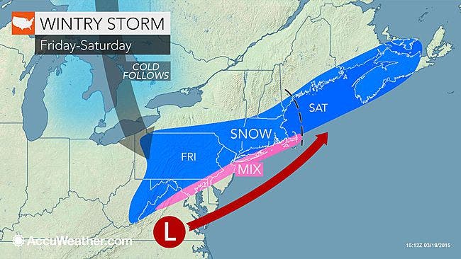
Here’s a timeline for Friday’s snow event from Hudson Valley Weather:
- Snow begins between 10am and 2pm on Friday
- Snow falls light to moderate at times thru the afternoon hours
- Snow tapers off from west to east between 6pm and 10pm on Friday
The evening rush hour could be affected, Sosnowski said, “Since paved surfaces absorb a considerable amount of warmth from the sun this time of the year, it would have to snow hard to make roads slippery during the daylight hours. However, even a light to moderate snow falling early in the morning, toward evening or at night can be enough to make roads slushy. Motorists should be on the lookout for slippery roads in the suburbs, as well as bridges, underpasses and areas that do not receive much sunlight.”
In all, the region could see 1-3 inches of accumulation.
Here’s the daily forecast from the NWS:
- Today-Sunny, with a high near 36. Wind chill values between 15 and 25. Northwest wind 11 to 13 mph.
- Tonight-Increasing clouds, with a low around 15. Light and variable wind.
- Friday-Snow, mainly after noon. High near 32. Wind chill values between 15 and 25. East wind 3 to 7 mph. Chance of precipitation is 80%. New snow accumulation of 1 to 3 inches possible.
- Friday Night-A chance of snow. Cloudy, with a low around 24. North wind around 6 mph. Chance of precipitation is 50%.
- Saturday-A slight chance of snow before noon. Partly sunny, with a high near 42. Calm wind becoming southwest around 6 mph in the afternoon. Chance of precipitation is 20%.
- Saturday Night-A slight chance of rain and snow showers before midnight, then a slight chance of snow showers. Partly cloudy, with a low around 25. Chance of precipitation is 20%.
- Sunday-Mostly sunny, with a high near 36.
- Sunday Night-Mostly clear, with a low around 18.
- Monday-Sunny, with a high near 36.
MAP: AccuWeather.com
Get more local news delivered straight to your inbox. Sign up for free Patch newsletters and alerts.