Weather
Hazardous Weather Outlook Issued for Westchester, Rockland, Putnam
We let you know when the thunderstorms are expected and also what to expect in Tarrytown and Sleepy Hollow for the rest of the week.

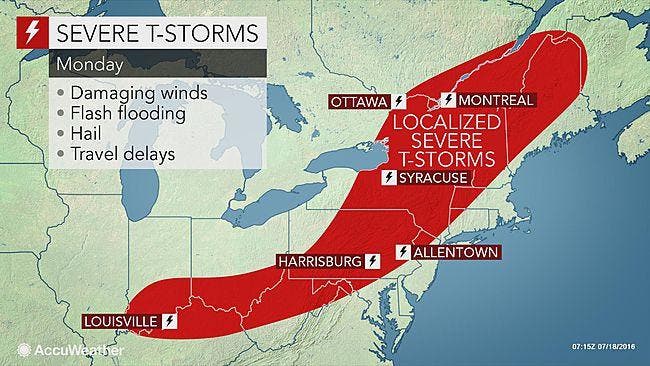
After a very hot and sunny July summer weekend, we’re back into it with a chance of some strong thunderstorms Monday afternoon and evening.
Get Patch’s Daily Newsletter and Real Time News Alerts
The National Weather Service has issued a Hazardous Weather Outlook for the lower Hudson Valley.
Find out what's happening in Tarrytown-Sleepy Hollowfor free with the latest updates from Patch.
Once the storms roll through, we get a temporary reprieve from the 90 degree readings we’ve been experiencing. But by the end of the week temps will be soaring back into the 90s.
The Hazardous Weather Outlook states:
Find out what's happening in Tarrytown-Sleepy Hollowfor free with the latest updates from Patch.
STRONG TO POSSIBLY SEVERE THUNDERSTORMS ARE PROBABLE THIS AFTERNOON
AND EVENING. THE MAIN THREAT IS STRONG DAMAGING WINDS.
The storms are along the leading edge of the front creating triple-digit temperatures in the Midwest.
The Air Quality Index for July 18 is 100 — Moderate. To help reduce pollution levels, refrain from unnecessary driving and use public transportation if available.
Here's the NWS forecast for the work week in southern Westchester County:
- Today: A 20 percent chance of showers and thunderstorms after 1pm. Some of the storms could produce gusty winds and heavy rain. Partly sunny, with a high near 90. Southwest wind 6 to 14 mph.
- Tonight: Showers and thunderstorms likely, mainly before midnight. Some of the storms could produce gusty winds and heavy rain. Mostly cloudy, with a low around 70. West wind 7 to 10 mph. Chance of precipitation is 60%. New rainfall amounts between a tenth and quarter of an inch, except higher amounts possible in thunderstorms.
- Tuesday: Sunny, with a high near 85. Northwest wind around 8 mph.
- Tuesday Night: Mostly clear, with a low around 63. North wind around 7 mph.
- Wednesday: Sunny, with a high near 81. North wind 3 to 7 mph.
- Wednesday Night: Mostly clear, with a low around 65.
- Thursday: Sunny, with a high near 88.
- Thursday Night: Partly cloudy, with a low around 70.
- Friday: Mostly sunny, with a high near 94.
- Friday Night: Partly cloudy, with a low around 74.
SEE ALSO:
- Hudson Valley Man Tells Police He Wanted to Die Before Being Shot and Killed
- 'Kidnapping' Phone Scams Increasing in the Mid-Hudson Valley
- Rockland County Exec Implements Austerity Measures to Count $4M Deficit
MAP: AccuWeather.com
Get more local news delivered straight to your inbox. Sign up for free Patch newsletters and alerts.