Weather
NYC's Coldest Weekend This Winter To Bring Snow And Deep Freeze, Forecasters Say
A Wind Advisory and an Extreme Cold Warning will be in effect for the city over the weekend.

NEW YORK CITY — New York City is bracing for the season's coldest weekend yet, with snow Friday night, sub-zero temperatures and strong winds, according to the latest forecast.
The deep freeze is brought on by Arctic air, which is blasting into Canada and the Northeast, bringing a burst of snow overnight on Friday into Saturday morning, along with gusty winds.
The National Weather Service forecast indicates a high near 31 degrees on Friday, with wind chill values between 15 and 25 degrees.
Find out what's happening in Upper West Sidefor free with the latest updates from Patch.
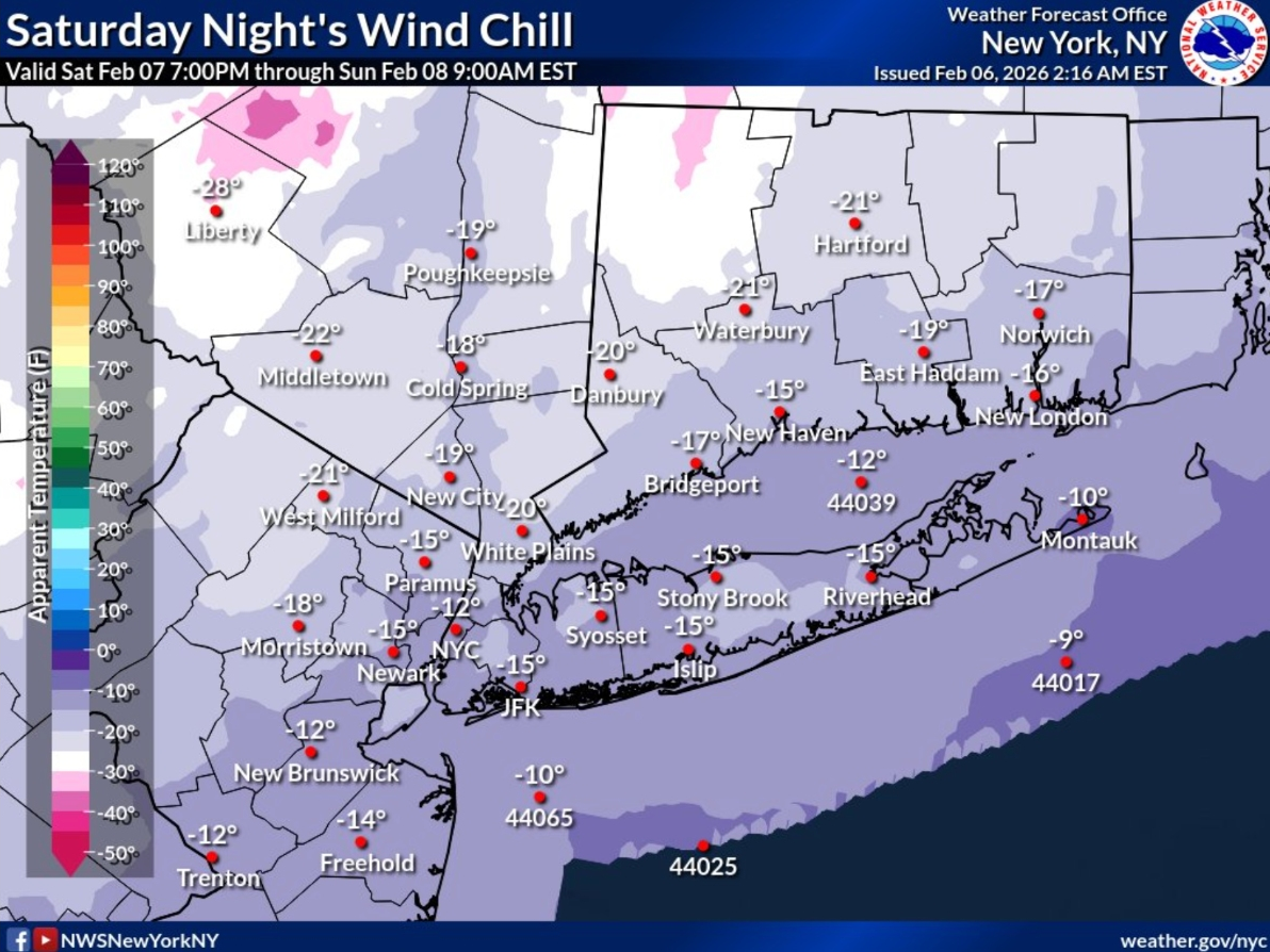
Snow is expected Friday night, primarily between 1 a.m. and 4 a.m. The low temperature will be around 18 degrees. The chance of precipitation is 80 percent, with new snow accumulation of a little less than one inch. Both a Wind Advisory and an Extreme Cold Warning will be in effect for the city over the weekend, from Saturday into Sunday.
🌨️Light snow is expected to begin late this eve & continue into Sat AM. The snow may linger into early Sat PM across E L.I. & SE CT. Up to an inch forecast around the NYC metro on NW with 1-2" further east. A few spots over the forks of L.I. and SE CT could see up to 3". pic.twitter.com/2MKoge7dTB
— NWS New York NY (@NWSNewYorkNY) February 6, 2026
Saturday will see a 40 percent chance of snow, mainly before 1 p.m., with temperatures falling to around 12 degrees by 5 p.m. Wind chill values are predicted to be between -5 and 5 degrees. The forecast calls for blustery conditions, with a northwest wind ranging from 11 to 20 mph and gusts as high as 46 mph.
Find out what's happening in Upper West Sidefor free with the latest updates from Patch.
Saturday night will be partly cloudy, with a low around 6 degrees. Wind chill values are expected to be between -5 and -10 degrees. Blustery conditions will continue, with a northwest wind between 15 and 20 mph and gusts potentially reaching 47 mph.
Sunday is forecast to be sunny and cold, with a high near 19 degrees. A northwest wind of 11 to 14 mph is expected, with gusts as high as 30 mph. Sunday night will be mostly clear, with a low around 9 degrees.
To combat the cold, the city recommends dressing in loose, warm layers. Important areas to cover include the face, hands, ears, and feet. Avoiding wet clothing is also crucial for maintaining body heat.
Community members are encouraged to check on older adults, people with medical needs, and neighbors during this period. Pet owners should bring their pets inside to protect them from the extreme temperatures.
Safety measures for home heating are also emphasized. Space heaters should be kept away from anything flammable and plugged directly into a wall socket; extension cords should never be used. The city also warns against using ovens or grills as heating sources for homes. To prevent frozen pipes, residents should let faucets drip and open cabinet doors under sinks.
For those experiencing heat or hot water issues, the city advises contacting landlords. If these issues remain unresolved, residents can contact 311 for assistance.
Warming centers are available for everyone needing heat. Locations for these centers can be found here.
Here is the latest forecast from the National Weather Service.
Friday night: Snow, mainly between 1am and 4am. Low around 18. Southwest wind around 7 mph. Chance of precipitation is 80 percent. New snow accumulation of less than one inch possible.
Saturday: A 40 percent chance of snow, mainly before 1pm. Cloudy and cold, with a temperature falling to around 12 by 5pm. Wind chill values between -5 and 5. Blustery, with a northwest wind 11 to 20 mph, with gusts as high as 46 mph.
Saturday night: Partly cloudy, with a low around 6. Wind chill values between -5 and -10. Blustery, with a northwest wind 15 to 20 mph, with gusts as high as 47 mph.
Sunday: Sunny and cold, with a high near 19. Northwest wind 11 to 14 mph, with gusts as high as 30 mph.
Sunday night: Mostly clear, with a low around 9.
For questions and tips, email Miranda.Levingston@Patch.com.
Get more local news delivered straight to your inbox. Sign up for free Patch newsletters and alerts.