Community Corner
Snow Chances to Follow Mild Weekend
A coastal storm looks likely to impact Long Island next week, but will it bring snow or rain? Check out the latest forecast.

It will feel a bit like spring on Long Island this weekend as temperatures rise into the 50s, but forecasters are closely watching a developing storm system that could bring snow to the region next week.
Before we talk snow, let’s take a look at the gorgeous weekend ahead: skies are expected to be mostly sunny with a high around 53 on Saturday and near 51 on Sunday.
Things will cool down on Sunday night and there will be a chance of snow and rain late Sunday night through Monday morning. No snow accumulations are expected.
Find out what's happening in West Islipfor free with the latest updates from Patch.
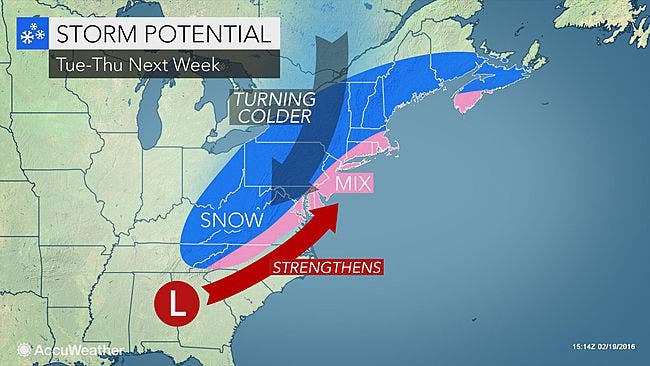
The larger snow threat will begin on Tuesday.
“There is moderate confidence that there will be a storm system to affect the area Tuesday into possibly Thursday, but details are quite uncertain,” the National Weather Service says.
Find out what's happening in West Islipfor free with the latest updates from Patch.
At the moment, the NWS says snow will be likely on Long Island Tuesday night and Wednesday morning before the snow turns to rain. There will also be a chance of snow Wednesday night and Thursday.
“The challenge now is that even though we see that a storm will develop, it has not formed yet,” AccuWeather Chief Meteorologist Elliot Abrams said. “Until it does develop, its exact path and full effects cannot be pinpointed at this time.”
Get more local news delivered straight to your inbox. Sign up for free Patch newsletters and alerts.