Weather
Hurricane Florence: NC Could See 'Staggering' Amounts Of Rain
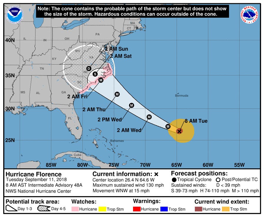
A hurricane watch is in effect from Edisto, SC to the NC-Virginia border, and forecasters now warn of possible 12-foot storm surge.


While Hurricane Florence remains days away from making landfall in North Carolina, there is “increasing risk of life-threatening impacts,” from inland flooding and storm surge along the coast, according to state emergency officials.
As of 2 p.m. Tuesday, the Category 4 hurricane was located about 845 miles east-southeast of Cape Fear, N.C. with sustained wind speeds of about 130 mph, according to the National Weather Service. A hurricane watch and storm surge watch are in effect from Edisto Beach, S.C. to the North Carolina-Virginia border, as well as for the Albemarle and Pamlico Sounds.
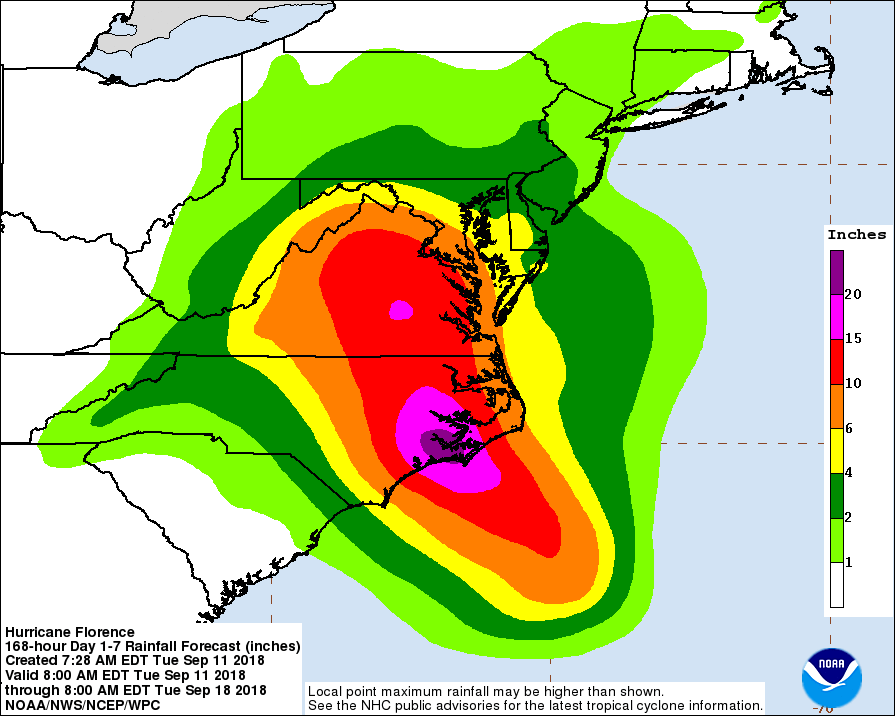
The storm surge along the coastal area ranging from 3 to 12 feet is expected Thursday through Sunday, NC Emergency Management said Tuesday. Further inland, flooding is anticipated in the eastern portion of the state, with rain potential of 15-20 inches. Central North Carolina could see 6-15 inches, NCEM said.
Find out what's happening in Charlottefor free with the latest updates from Patch.
In addition to flooding, dangerous winds are anticipated to topple trees and down power lines throughout the state.
National Hurricane Center Director Ken Graham said in a Facebook Live video Monday afternoon called the storm a dangerous situation, as it has a pronounced eye and rain bands on the outskirts of the storm.
Find out what's happening in Charlottefor free with the latest updates from Patch.
“That’s where we see a system is really self-sustaining,” said Graham. “And that’s where you have a hurricane that continues to strengthen. It’s what we call breathing, so to speak. All the structure is absolutely perfect to continue as strong as it is.”
Graham noted there will be impacts far outside the cone from rainfall and strong winds. He said the storm will almost “park” over North Carolina.
“That spells problems because the longer it waits, the more that it sits the more rain we have,” he said, adding that water kills 90 percent of people in tropical systems. “That’s why we focus so much on it.”
In North Carolina, there will be “staggering” amounts of rainfall approaching 10-15 inches or more of rain in many areas, Graham warned. Saturated soil, high winds and downed trees and power lines are going to be a big issue, he said, adding that a dangerous, life-threatening storm surge could occur all the way up through the Virginia coast.
“Flash flooding is going to be a significant concern and if you think you’re safe because you’re away from the coast, that is not true,” he said. “Well away from the coast, central portions of Virginia and North Carolina you could be 100 miles away from the coast, several hundred miles from the center and you could still get those dangerous rains that get flash flooding.”
The Charlotte metro area could begin to see tropical storm force winds as soon as Thursday morning, according to the National Weather Service. The region is also expected to receive 4-6 inches or more of rain.
Along the coast in Hyde County, North Carolina, the impacts of the storm are already being felt on Ocracoke Island, where the surf was seen about a quarter of a mile inland.
(Stay on top of Hurricane Florence coverage by subscribing to our free email alerts. Find your local Patch here. If you have an iPhone, click here to get the free Patch iPhone app; download the free Patch Android app here.)
North Carolina was granted a Federal Disaster Declaration Sept. 10, which will help speed Federal aid to the state. Days earlier, Gov. Roy Cooper declared a state of emergency Sept. 7 through the signing of Executive Order No. 51, which temporarily relaxed transportation rules regarding caps on maximum hours of service and weight restrictions for heavy trucks in order to help farmers in need of harvesting and transporting their crops ahead of the storm.
"While it's still too early to know the storm's path, we know we have to be prepared," Cooper said.
Tues morn #FlorenceNC update: * Get ready NOW! * Life-threatening impacts possible * Dangerous storm surge Thurs-Sun. 3-12' * Flooding inland. Eastern NC 15-20"; central NC 6-15" * Storm surge /Hurricane Watch for all NC coast * Dangerous winds will down trees & knock out power pic.twitter.com/puIu6X7aeT
— NC Emergency Managem (@NCEmergency) September 11, 2018
Hurricane Preparation Tips
- Take action now to be prepared for hurricane season. As the storm approaches, it is often too late to get ready. Make sure you have family evacuation and communications plans, update your emergency supply kit, and evaluate your flood insurance needs.
- Complete a family communication plan. Plan how you will assemble your family and loved ones and anticipate where you will go for different situations. Get together with your family and agree on the ways to contact one another in an emergency and identify meeting locations.
- Create or restock your emergency kit. Being prepared means having your own food, water and other supplies to last for at least 72 hours. A disaster supplies kit is a collection of basic items your household may need in the event of an emergency, including an all weather radio.
- Check your insurance coverage. Most homeowner's insurance policies do not cover damage or losses from flooding. Review your policy, ensure you're adequately covered and understand exclusions, and contact your agent for any changes.
- Stay Informed. Know where to go for trusted sources of information during a hurricane event. Monitor local news resources for hurricane watches and warnings and follow directions of local officials.
- Determine Your Risk. Find out what types of wind and water hazards are likely in your area. Hurricanes are not just a coastal problem and their effects can reach hundreds of miles inland. Since the U.S. has not been hit by a major hurricane (category 3 or higher) in over a decade, "many people are suffering from hurricane amnesia in the forms of complacency, denial and inexperience."
- Develop an Evacuation Plan. Find out if you live in a storm surge hurricane evacuation zone or if your home is unfit to keep you safe in a hurricane. Speak with family and friends and work out a plan to use their home as an evacuation destination. Be sure to account for pets, since many shelters do not allow them.
- Assemble Disaster Supplies. Supplies are necessary not just for the storm itself, but for the often long and grueling aftermath. Stock up on non-perishable food, water and medicine to support your family for at least a week. Other recommended items are cash and battery-powered radios and flashlights. Since many of us use cell phones, have a solar-powered or hand-crank USB charger.
- Know Your Risk and Plan Ahead for an Evacuation.Know how to receive information including recommendations or orders to evacuate.
- If you plan to go to a shelter, notify staff of any special needs you or your family have.
- Do not return to the evacuation area until the evacuation order is lifted.
Technology has made it easier to prepare for emergencies, but it can be unreliable during big storms if you haven't planned to keep your gadgets protected and powered up. Here are some tips to make sure you are tech ready:
- Download the FEMA app. Receive weather alerts from the National Weather Service for up to five different locations anywhere in the United States. To search for open shelters (for disaster survivors): text SHELTER and a Zip Code to 43362 (4FEMA)
- Make A Social Media Plan. Use text messages, social media and email to connect with friends and family during emergencies.
- Mobile networks can become overwhelmed during emergencies, making it difficult to place and receive phone calls. Text messages require less bandwidth, which means they are able to be transmitted more reliably.
- Social media channels such as Facebook and Twitter can also be an effective way to update family and friends during emergencies. Facebook's Safety Check feature allows users to easily post a status update indicating that they are safe during a time of disaster.
- Register with American Red Cross's Safe & Well site to let family and friends know you're okay.
- Have an emergency charging option for your phone and other mobile devices. Smartphones have become a vital tool to receive emergency alerts and warnings,, so it's important to make sure you can keep them powered up in an emergency.
- At home: Before severe weather, charge all of your electronic devices. If the power goes out, preserve battery power by minimizing device use. Keep a back-up power source on hand to recharge your phone so that you can stay connected even during an extended power outage.
- In your car: Keep a portable phone charger in your vehicle at all times, and consider purchasing a back-up power supply to keep in your vehicle as well.
- Change the settings on your phone to low power mode or place it on airplane mode to conserve energy.
- Store important documents in a secure, password-protected jump drive or in the cloud.
- Capture electronic versions of important documents such as insurance policies, identification documents, and medical records. Don't forget to include your pet's information.
- Back-up your computer to protect photos and other personally important electronic documents.
- Scan old photos to protect them from loss.
Additional information can be found on the Ready NC website.
RELATED:
- Hurricane Florence: How North Carolina Can Prepare
- NC Residents Advised To Review Homeowners Insurance Now
- Where To Find Gas In NC: Hurricane Florence Evacuation
- Hurricane Florence Prep: How To Keep Kids Safe And Calm
- List Of Mandatory Evacuations Expands In North Carolina
Patch editor Dan Hampton contributed to this report.
Main Image: National Weather Service
Get more local news delivered straight to your inbox. Sign up for free Patch newsletters and alerts.