Weather
Hurricane Irma: Gov. Cooper Warns ‘We Can’t Let Our Guard Down’
Hurricane Irma predicted hit in Western North Carolina could cause floods, tornadoes and landslides, Cooper warns.

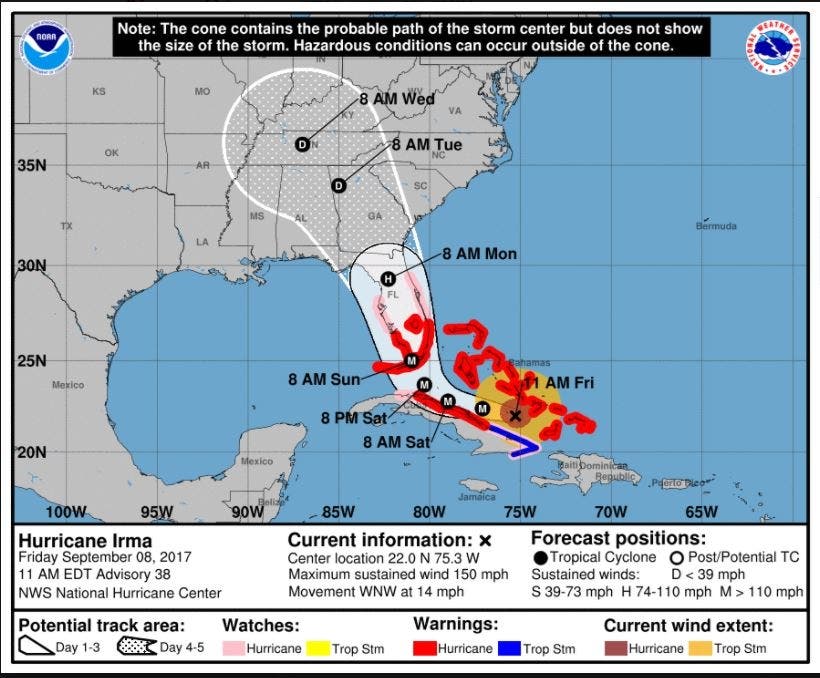
CHARLOTTE, NC -- The latest track of Hurricane Irma shows the path of the Category 4 storm shifting westward, which is good news for North Carolina, but could still lead to flash flooding, tornadoes and even landslides in the mountain areas.
“Things are looking better for North Carolina but we can’t let our guard down,” N.C. Gov. Roy Cooper said Friday afternoon at a press conference.
Irma is “roughly the size of the state of Texas,” Cooper said. “We know that even if North Carolina is spared a direct hit some parts of our state could still see serious impacts, particularly in the Western part of our state.(Get Patch real-time email alerts for the latest news in Charlotte — or other neighborhoods. And iPhone users: Check out Patch's new app.)
Find out what's happening in Charlottefor free with the latest updates from Patch.
Watch: Florida Braces As Irma Rips Across The Caribbean
The NWS’ 11 a.m. forecast shows that by 8 a.m. Sept. 12, Irma’s cone will flank the western edge of North Carolina and South Carolina, bringing rain and sustained tropical winds up 39 mph to the region. The cone, however, will just skirting the Queen City metro area to the west. A day later, the storm will be centered over central Tennessee.
Find out what's happening in Charlottefor free with the latest updates from Patch.
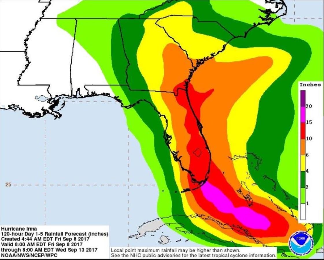
According to the National Hurricane Center, Western North Carolina, South Carolina and Georgia will experience periods of heavy rain, which will lead to a risk of flooding and flash flooding.
“There’s a chance of direct impacts in portions of Georgia, South Carolina and North Carolina, but it’s too early to specify the magnitude and location of these impacts,” the National Weather Service said Friday morning.
Cooper, who said Friday the state-wide emergency would stay in effect until the storm passed, has stressed that residents should prepare even as projections had a weakened Irma entering the state well inland early next week.
"This storm can impact any part of North Carolina — all over our state from the mountains to the coast," Cooper said. "Just because that it might be at tropical-storm strength doesn't mean this storm isn't going to be very dangerous."
On its current path, Irma is expected to clear the northern Cuban coastline by Saturday and make its way up the center of Florida in the early morning hours Monday. Forecasters say Irma’s hurricane-force winds extend out 70 miles from the center while tropical storm-force winds reach out 185 miles.
Patch Editor Sherri Lonon and the AP contributed to this report.
Images from the National Weather Service
Keep up with more Hurricane Irma news by liking Charlotte Patch on Facebook:
Get more local news delivered straight to your inbox. Sign up for free Patch newsletters and alerts.