Weather
Hurricane Michael: NC Waits As ‘Monstrous’ Storm Slams Florida
NC is bracing for heavy storm rains leading to potential flash flooding and river flooding from the piedmont to the coastal plain.


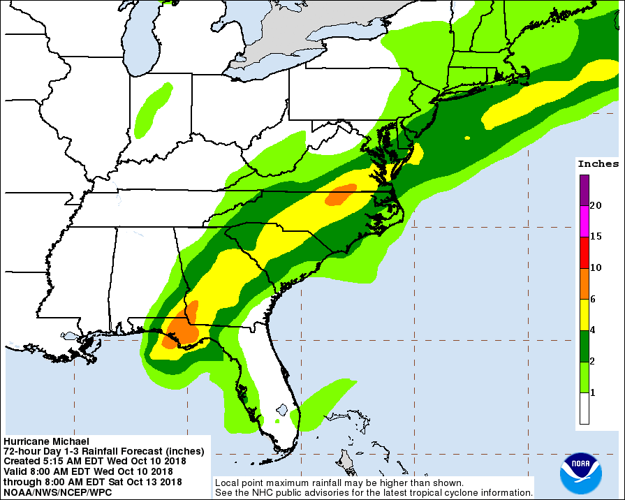
CHARLOTTE, NC — As Hurricane Michael began to lash Florida with heavy rains and winds Wednesday, flooding fears were renewed in an already waterlogged North Carolina, parts of which are expecting the storm to deliver Tropical Storm winds and up to 6 inches of rain.
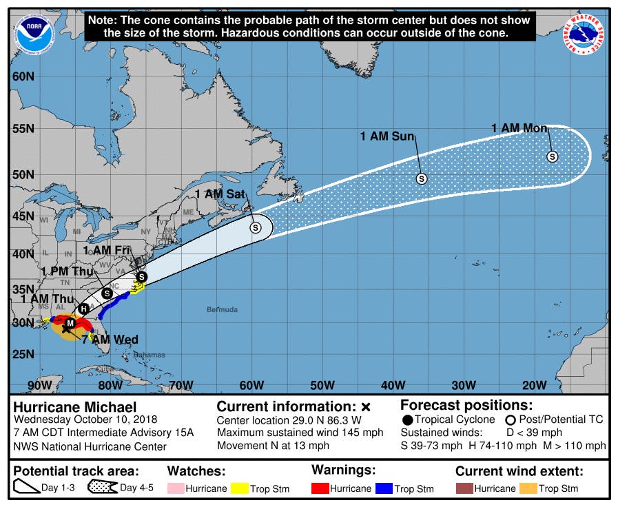
The storm delivered unprecedented 155 mph winds as it made landfall in Mexico Beach, Florida as a category 4 storm on Wednesday afternoon, and still packed 125 mph winds as it cut a path of devastation through the Florida Panhandle and headed for Alabama and Georgia, according to the National Hurricane Center. Michael ripped roofs from homes, sank boats, carried life-threatening storm surge, hurricane force winds and heavy rainfall as it slammed into Florida. Even as the storm made its way out of Florida, it was still a dangerous category 3.
"Let me be clear, " Florida Gov. Rick Scott said before it made landfall. "Hurricane Michael is a monstrous storm and we're just hours away from seeing impacts. This is the most destructive storm to hit the Panhandle in decades. This storm could kill you."
Find out what's happening in Charlottefor free with the latest updates from Patch.
By Thursday, the impacts will be felt across North Carolina, forecasters said. The storm is expected to dump 3-6 inches of rain across much of the piedmont of North Carolina. Winds are expected to pick up Wednesday night and peak Thursday, with a few tropical-storm force gusts possible and a risk of isolated tornadoes in the lower piedmont of the state, NWS said.
“The Charlotte metro area is at particular risk of flash flooding, due to very high rainfall rates developing tomorrow along with excessive urban runoff,” the National Weather Service said Wednesday afternoon. “Areas that flooded during heavy rainfall last month with Tropical Storm Florence may flood again during Michael.”
Find out what's happening in Charlottefor free with the latest updates from Patch.
In a press conference Tuesday, North Carolina Gov. Roy Cooper urged North Carolina residents to pay attention to Hurricane Michael.“I know people who weathered Florence last month and other storms before don’t want to even think about another one,” Cooper said. “But we have to. So I’m asking you to be watchful and alert, and to get ready.”
The state continues to reel from the destruction of last month’s Hurricane Florence, that has been blamed for the deaths of 39 and catastrophic flooding throughout eastern North Carolina. As of Monday, more than 130 schools in the state remained closed due to damage from the hurricane, affecting almost 90,000 students, prompting Cooper to direct $25 million for the NC Education Lottery to aid in school repairs.
Unlike the rains from Hurricane Florence that churned over the state for days, Michael is expected to pass through North Carolina quickly with weather conditions improving by Friday, Cooper said.
“We know we have to be ready and hurricane weary North Carolinians cannot let their guard down,” Cooper said.
Here’s what emergency officials are urging North Carolina residents do to prepare:
- review emergency plans
- restock emergency supplies, including food, water, flashlights, extra batteries, and medications
- prepare for possible power outages
- stay tuned to local news and monitor weather forecasts closely
- know evacuation routes in case you are asked to leave
- plan in advance how to contact family and friends
SEE ALSO: ‘Hurricane Weary’ North Carolina Bracing For Michael's Rain
Here is the National Weather Service forecast through Monday, Oct. 15:
Today (Oct. 10)
Showers, with thunderstorms also possible after 11am. Patchy fog before 3pm. High near 77. East southeast wind around 10 mph, with gusts as high as 18 mph. Chance of precipitation is 80%. New rainfall amounts between a quarter and half of an inch possible.
Tonight
Showers and thunderstorms likely, then showers and possibly a thunderstorm after 2am. Patchy fog. Low around 72. East southeast wind around 9 mph. Chance of precipitation is 80%. New rainfall amounts between a quarter and half of an inch possible.
Thursday (Oct. 11)
Tropical storm conditions possible. Showers and possibly a thunderstorm. Some of the storms could produce heavy rainfall. Patchy fog before 2pm. High near 77. Chance of precipitation is 100%. New precipitation amounts between 3 and 4 inches possible.
Thursday Night
Showers likely before 10pm, then a chance of rain between 10pm and 2am. Mostly cloudy, then gradually becoming mostly clear, with a low around 58. North northwest wind 13 to 16 mph, with gusts as high as 26 mph. Chance of precipitation is 60%. New precipitation amounts between three quarters and one inch possible.
Friday (Oct. 12)
Sunny, with a high near 73. North northwest wind 6 to 9 mph.
Friday Night
Mostly clear, with a low around 51.
Saturday (Oct. 13)
Sunny, with a high near 70.
Saturday Night
Mostly clear, with a low around 51.
Sunday (Oct. 14)
Mostly sunny, with a high near 72.
Sunday Night
Partly cloudy, with a low around 58.
Monday (Oct. 15)
A 30 percent chance of showers and thunderstorms. Partly sunny, with a high near 76.
(Stay on top of all the latest Hurricane Michael news with our free, real-time news alerts, find your local Patch here. If you have an iPhone, click here to get the free Patch iPhone app; download the free Patch Android app here. And like Patch on Facebook!)
Patch Editor D’Ann Lawrence White contributed.
Image via National Weather Service Raleigh
Get more local news delivered straight to your inbox. Sign up for free Patch newsletters and alerts.