Weather
Tropical Storm Michael: Here’s When NC Will See Rain
The storm is expected to strengthen to a hurricane and strike the Gulf Coast this week before heading toward the Carolinas.

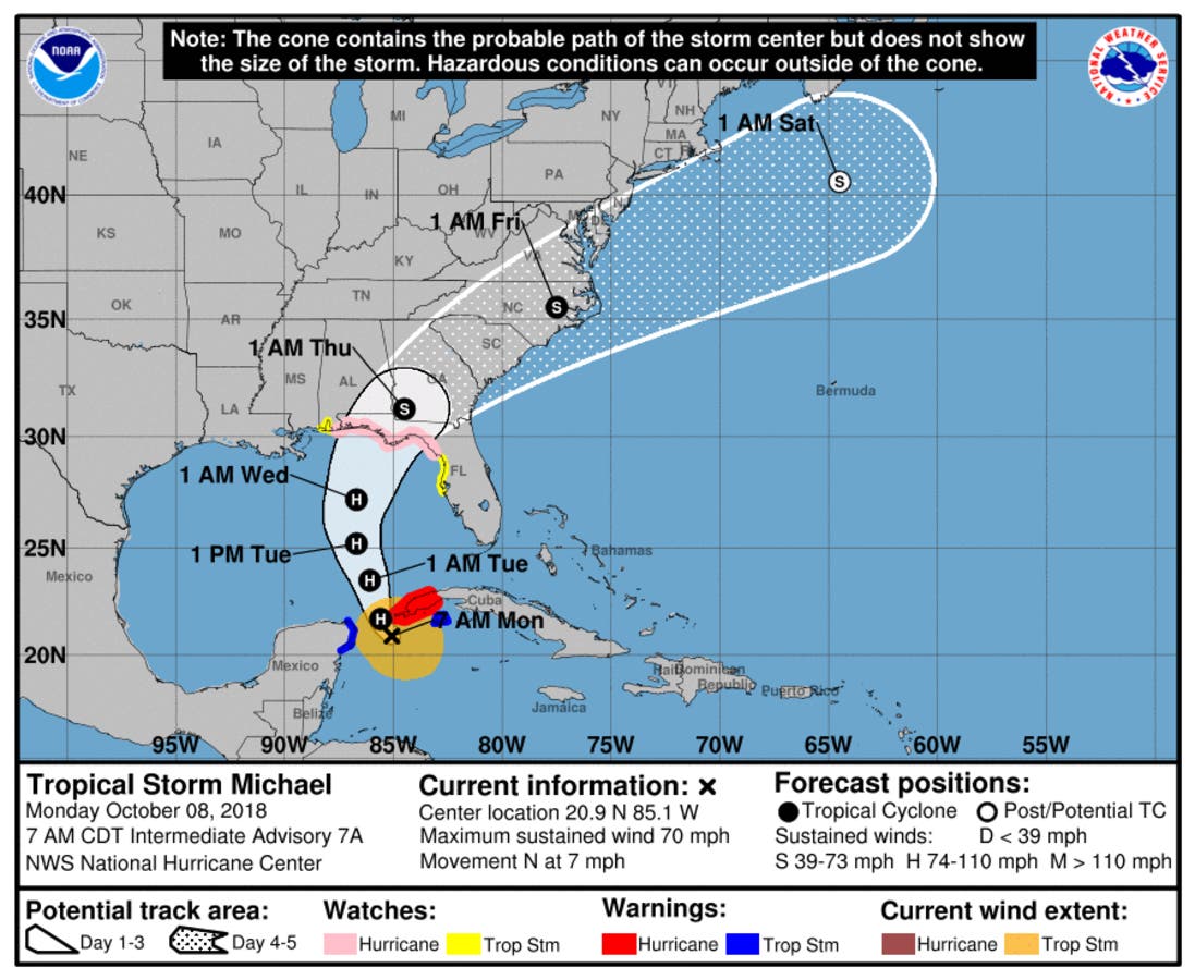
CHARLOTTE, NC — Just as North Carolina begins to dry out from the deluge brought by Hurricane Florence, another hurricane brewing in the Gulf threatens to drench the southeastern U.S. this week, including the Carolinas. Tropical Storm Michael was just off the coast of Cuba Monday morning as it headed for the southeastern U.S., according to the National Hurricane Center.
Michael is expected to strengthen into a Category 2 hurricane before making landfall along Florida or Alabama in the middle of this week, AccuWeather senior meteorologist Kristina Pydynowski writes.
The storm will then track toward Georgia and Carolinas, which will begin to feel its winds Wednesday into Thursday.
Find out what's happening in Charlottefor free with the latest updates from Patch.
Latest #ncwx: TD14 may be TS Michael later today. Likely cause heavy rain in NC later in week; not yet sure where /how much. Current 7-day forecast is 3-5” of rain across SE mtns & SE parts of NC. Heaviest rain likely Wed. night – early Fri. Also may see gusty winds. Stay tuned pic.twitter.com/0ahk0Nzpgz
— NC Emergency Managem (@NCEmergency) October 7, 2018
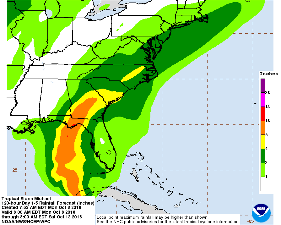
While Michael won't directly hit North Carolina, it's expected to bring a fair amount of rain to the area — up to 4 inches across much of the state, with up to 6 inches in some portions of the region east of Raleigh, according to the National Hurricane Center's latest projection. The weather service says to expect a chance of showers every day this week, until Friday night.
(For more news like this, find your local Patch here. If you have an iPhone, click here to get the free Patch iPhone app; download the free Patch Android app here.)
Find out what's happening in Charlottefor free with the latest updates from Patch.
Here is the National Weather Service’s forecast for the work week:
Columbus Day (Oct. 8)
A slight chance of showers, then a chance of showers and thunderstorms after 10am. Patchy fog before 9am. Otherwise, mostly cloudy, with a high near 82. East wind 5 to 8 mph. Chance of precipitation is 40%. New rainfall amounts of less than a tenth of an inch, except higher amounts possible in thunderstorms.
Tonight
A chance of showers and thunderstorms before 11pm, then a slight chance of showers after midnight. Patchy fog after 5am. Otherwise, mostly cloudy, with a low around 68. East wind around 8 mph. Chance of precipitation is 40%. New precipitation amounts of less than a tenth of an inch, except higher amounts possible in thunderstorms.
Tuesday (Oct. 9)
A chance of showers, with thunderstorms also possible after 5pm. Patchy fog before 8am. Otherwise, mostly cloudy, with a high near 80. East northeast wind 6 to 8 mph. Chance of precipitation is 40%. New rainfall amounts of less than a tenth of an inch, except higher amounts possible in thunderstorms.
Tuesday Night
A 50 percent chance of showers. Mostly cloudy, with a low around 70. East wind around 6 mph. New precipitation amounts between a tenth and quarter of an inch possible.
Wednesday (Oct. 10)
Showers likely, then showers and possibly a thunderstorm after 11am. High near 79. Southeast wind around 6 mph. Chance of precipitation is 80%.
Wednesday Night
Showers likely and possibly a thunderstorm. Cloudy, with a low around 71. Chance of precipitation is 70%.
Thursday (Oct. 11)
Showers likely and possibly a thunderstorm. Mostly cloudy, with a high near 80. Chance of precipitation is 70%.
Thursday Night
A 50 percent chance of showers. Mostly cloudy, with a low around 62.
Friday (Oct. 12)
A 30 percent chance of showers before 1pm. Mostly sunny, with a high near 73.
Friday Night
Partly cloudy, with a low around 52.
Saturday (Oct. 13)
Mostly sunny, with a high near 70.
Saturday Night
Partly cloudy, with a low around 51.
Sunday (Oct. 14)
Mostly sunny, with a high near 71.
Patch Editor Noah Manskar contributed
Images via National Hurricane Center
Get more local news delivered straight to your inbox. Sign up for free Patch newsletters and alerts.