Weather
Memorial Day: Just How Soggy Is Huntersville's Holiday Forecast?
There's no easy way to say it — the long holiday weekend is going to be soggy. Here's when you can expect the rain.


HUNTERSVILLE, NC — Memorial Day weekend is just around the corner, officially kicking off summer. This year’s holiday weekend, however, will go down in the books as a waterlogged three-day weekend, with showers and thunderstorms in the forecast clear into next week, according to forecasters.
The rain could start as early as Wednesday evening, according to the National Weather Service.
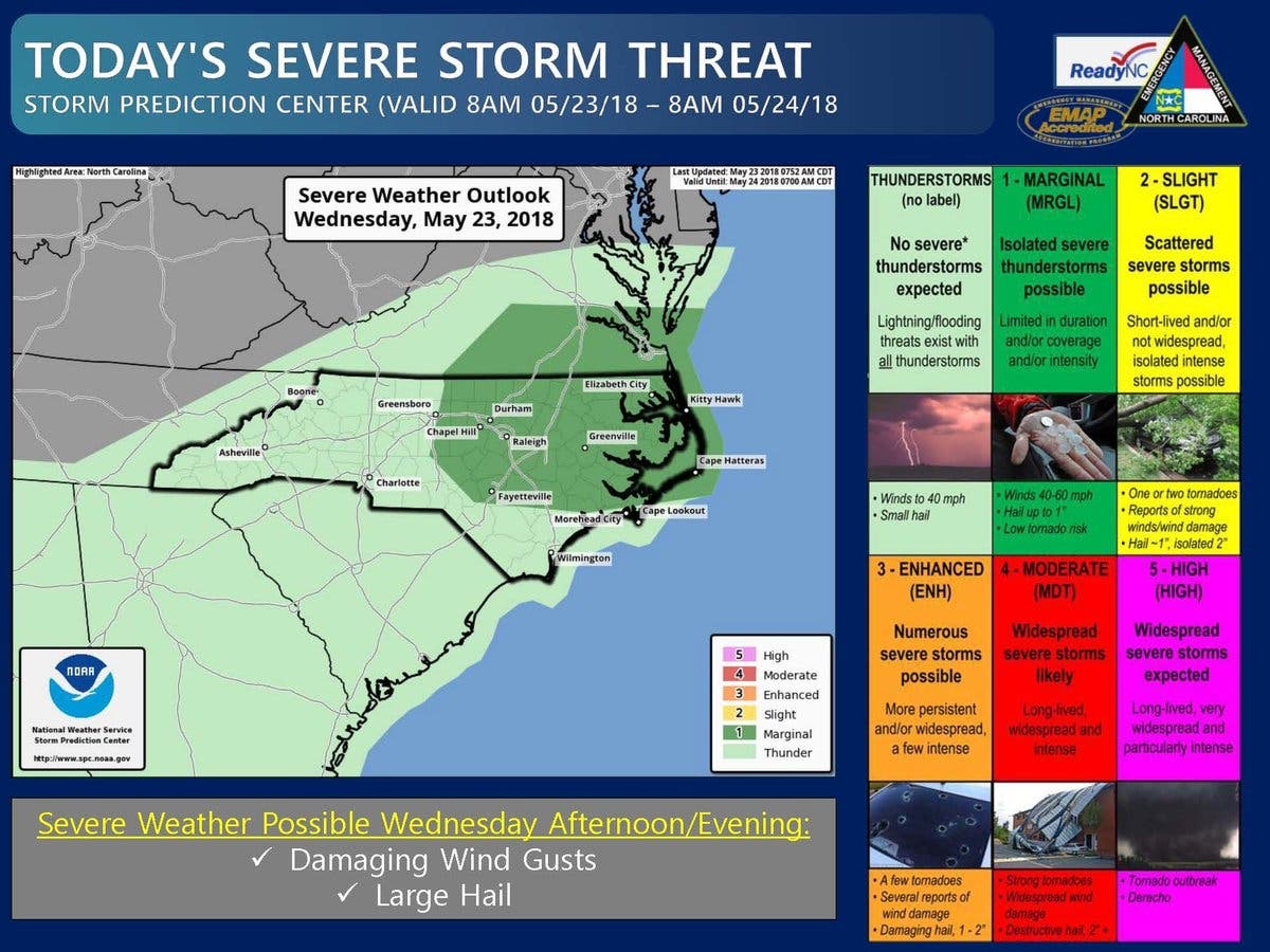
“Scattered thunderstorms will continue across the area into the evening hours,” the National Weather Service said in a hazardous outlook bulletin Wednesday. “Localized heavy rain and cloud to ground lightning will be the primary threats. Small hail and gusty winds will also be possible.”
Find out what's happening in Huntersvillefor free with the latest updates from Patch.
Wednesday’s weather prompted a severe storm threat warning from North Carolina Emergency Management, that said lightning and flooding could be possible in parts of the state, along with winds gusting up to 40 mile per hour and small hail.
The wet weather will continue next week, according to NWS forecasters, who say heavy rain with possible flooding will occur on Monday. “Tropical moisture interacting with a frontal zone may bring an organized heavy rainfall threat back to the region next week,” the bulletin said.
Find out what's happening in Huntersvillefor free with the latest updates from Patch.
Here’s your weekend weather forecast from the National Weather Service:
This Afternoon (May 23)
A 30 percent chance of showers and thunderstorms. Mostly cloudy, with a high near 84. Southwest wind around 7 mph. New rainfall amounts of less than a tenth of an inch, except higher amounts possible in thunderstorms.
Tonight
A 30 percent chance of showers and thunderstorms. Mostly cloudy, with a low around 69. Southwest wind around 6 mph becoming calm in the evening. New rainfall amounts between a quarter and half of an inch possible.
Thursday (May 24)
A 40 percent chance of showers and thunderstorms, mainly after 9am. Patchy fog before 9am. Otherwise, mostly cloudy, with a high near 81. Northeast wind 6 to 9 mph. New rainfall amounts between a quarter and half of an inch possible.
Thursday Night
A 40 percent chance of showers and thunderstorms, mainly before 3am. Mostly cloudy, with a low around 66. East wind 5 to 7 mph becoming calm after midnight. New rainfall amounts between a tenth and quarter of an inch, except higher amounts possible in thunderstorms.
Friday (May 25)
A 40 percent chance of showers and thunderstorms. Mostly cloudy, with a high near 82. Southeast wind around 6 mph.
Friday Night
A 40 percent chance of showers and thunderstorms. Mostly cloudy, with a low around 68.
Saturday (May 26)
A chance of showers between 11am and noon, then a chance of showers and thunderstorms after noon. Mostly cloudy, with a high near 83. Chance of precipitation is 40%.
Saturday Night
A chance of showers and thunderstorms. Mostly cloudy, with a low around 69. Chance of precipitation is 40%.
Sunday (May 27)
A 50 percent chance of showers. Mostly cloudy, with a high near 82.
Sunday Night
Showers likely. Cloudy, with a low around 69. Chance of precipitation is 60%.
Memorial Day (May 28)
Showers and thunderstorms likely. Cloudy, with a high near 80. Chance of precipitation is 60%.
Monday Night
Showers and thunderstorms likely. Cloudy, with a low around 70. Chance of precipitation is 60%.
Tuesday (May 29)
A 50 percent chance of showers and thunderstorms. Cloudy, with a high near 83.
Tuesday Night
A 50 percent chance of showers and thunderstorms. Mostly cloudy, with a low around 70.
Wednesday (May 30)
Showers and thunderstorms likely. Cloudy, with a high near 82.
(For more news like this, find your local Patch here. If you have an iPhone, click here to get the free Patch iPhone app; download the free Patch Android app here.)
Get more local news delivered straight to your inbox. Sign up for free Patch newsletters and alerts.