Weather
Flash Flood Watch Extended Through Wednesday: Mooresville Weather
Heavy rains from Subtropical Storm Alberto could trigger landslides and flash flooding, forecasters warn.


MOORESVILLE, NC — Heavy rains from Subtropical Storm Alberto will continue to impact North Carolina this week, as a line of storms continue to pummel an already saturated Tar Heel State. The National Weather Service has issued a Flash Flood Watch for the Western North Carolina and Piedmont region until Wednesday, May 30.
This week’s forecast includes heavy rain with possible flooding through Thursday, which could also lead to potential landslides for portions of North Carolina, Gov. Roy Cooper said Monday.
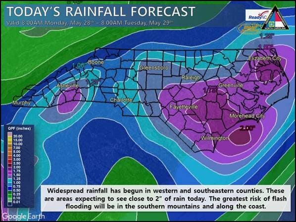
The Charlotte metro and Lake Norman regions received about an inch or more of rain Monday, according to state emergency officials.
Find out what's happening in Mooresvillefor free with the latest updates from Patch.
(For more news like this, find your local Patch here. If you have an iPhone, click here to get the free Patch iPhone app; download the free Patch Android app here.)
As Subtropical Storm Alberto continues to bring heavy rains, flooding & the potential for landslides to NC, @NC_Governor Roy Cooper urged residents to take seriously the storm, which has claimed two lives in the state https://t.co/r3VkvnscvK pic.twitter.com/6BgWc9XlZ8
— NC Emergency Managem (@NCEmergency) May 29, 2018
Here is this week’s forecast from the National Weather Service
Find out what's happening in Mooresvillefor free with the latest updates from Patch.
Tuesday (May 29)
A chance of showers and thunderstorms before 7am, then showers likely and possibly a thunderstorm between 7am and 11am, then showers and thunderstorms likely after 11am. Patchy fog before 10am. Otherwise, cloudy, with a high near 83. Southeast wind around 8 mph. Chance of precipitation is 70%. New rainfall amounts between a quarter and half of an inch possible.
Tuesday Night
Showers and thunderstorms likely. Cloudy, with a low around 71. Southeast wind 6 to 8 mph. Chance of precipitation is 70%. New rainfall amounts between a quarter and half of an inch possible.
Wednesday (May 30)
Showers and thunderstorms likely. Cloudy, with a high near 83. South wind 6 to 8 mph. Chance of precipitation is 60%. New rainfall amounts between a quarter and half of an inch possible.
Wednesday Night
A 50 percent chance of showers and thunderstorms. Cloudy, with a low around 71. South southwest wind 5 to 7 mph.
Thursday (May 31)
A 50 percent chance of showers and thunderstorms. Mostly cloudy, with a high near 85.
Thursday Night
A 40 percent chance of showers and thunderstorms before 1am. Mostly cloudy, with a low around 71.
Friday (June 1)
A 30 percent chance of showers and thunderstorms after 7am. Partly sunny, with a high near 88.
Friday Night
A 30 percent chance of showers and thunderstorms. Mostly cloudy, with a low around 71.
Saturday (June 2)
A chance of showers, with thunderstorms also possible after 9am. Mostly sunny, with a high near 88. Chance of precipitation is 30%.
Saturday Night
A 30 percent chance of showers and thunderstorms. Partly cloudy, with a low around 70.
Sunday (June 3)
A 40 percent chance of showers and thunderstorms. Partly sunny, with a high near 84.
Sunday Night
A 50 percent chance of showers and thunderstorms. Mostly cloudy, with a low around 68.
Photo courtesy of the NC Emergency Management
Get more local news delivered straight to your inbox. Sign up for free Patch newsletters and alerts.