Community Corner
Eagle Creek Fire: Evacuations, Acreage, How Weekend Weather May Help
Fire crews established 17 percent containment heading into Thursday, though the fire also grew another 2,000 acres, making the total 37,567.

CASCADE LOCKS, OR — The Oregon State Fire Marshal on Thursday announced fire crews in the Columbia River Gorge had achieved 17 percent containment of the nearly two-week-old Eagle Creek Fire, which as of Sept. 14 has burned more than 37,500 acres of Multnomah and Hood River counties' forests.
The Eagle Creek Fire began around 4 p.m. Saturday, Sept. 2, after a 15-year-old boy from Vancouver, Washington, allegedly threw a firecracker into the Eagle Creek Canyon. It's growth over that first weekend was tremendous, expanding more than 10,000 acres, merging with the Indian Creek Fire and burning so intensely that it started another fire across the Columbia River on Archer Mountain in Washington (which as of Wednesday was 100 percent contained).
Fire crews from local fire districts in the Portland metro region, along with state fire crews, have worked hard to contain the fire and prevent it from spreading not only into the several small communities in the Columbia River Gorge but also into the Bull Run watershed, which provides a large portion of Portland residents with drinking water.
Find out what's happening in Greshamfor free with the latest updates from Patch.
According to state officials, that's part of the reason why supertanker fire retardant hasn't been used on the Eagle Creek Fire — they're trying to avoid poisoning the water supply of Oregon's largest city. Yet the fire continues to grow concurrently with the percentage that's being contained.
On the northeast corner, nearest to Cascade Locks, wind moved the fire beyond Nick Eaton Ridge Wednesday, the fire marshal said, noting the fire is expected to continue growing on its Southside, fueled primarily by typical windy gorge weather. Helicopters will continue to slow the fire's pace with water bucket drops while crews on the ground — totaling more than 900 people — work to strengthen contingency lines along the Interstate-84 corridor from Herman Creek to Mitchell Point and from Bridal Veil to Warrendale.
Find out what's happening in Greshamfor free with the latest updates from Patch.
Crews repaired the damaged power lines serving Cascade Locks, the fire marshal said, allowing the lines to be re-engergized.
Other crews will continue to monitor and patrol residential areas to ensure the hundreds of threatened homes remain intact and untouched by fire.
On Thursday, Hood River County officials altered evacuation levels in several areas south of Cascade Locks
From the Hood River County Sheriff's Office:
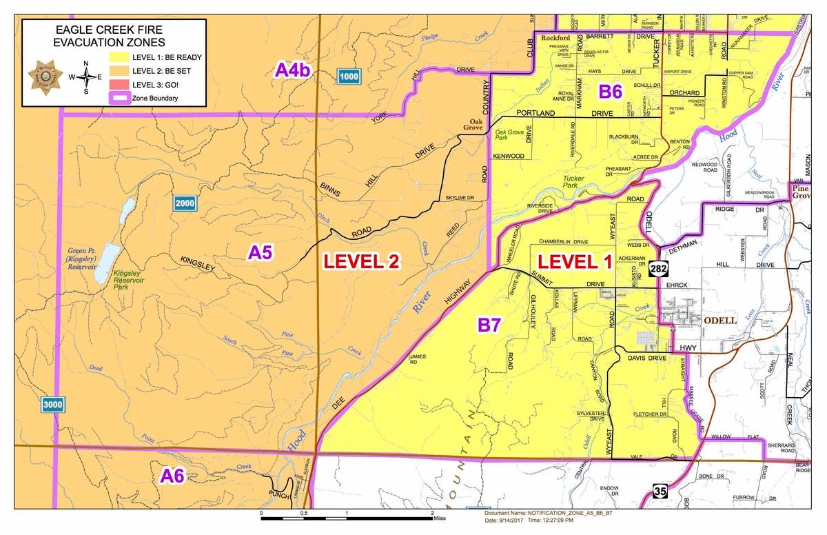
Zones A5 and A6 are being placed on Level Two evacuation notices.
Adding in the current Level 2 zone of A4b, the new boundaries for Level 2 will be defined as follows: The northern boundary will be the Columbia River, and the southern boundary will be the south end of Collins Road in Dee. The eastern boundary runs south from 430 Country Club and follows Country Club down to Reed Road, then runs overland due south to Hwy. 281, continuing along 281 to milepost 12.5, then following the Middle Fork of the Hood River until it comes parallel with the south end of Collins Road. The western boundary includes the Kinglsey Reservoir area.
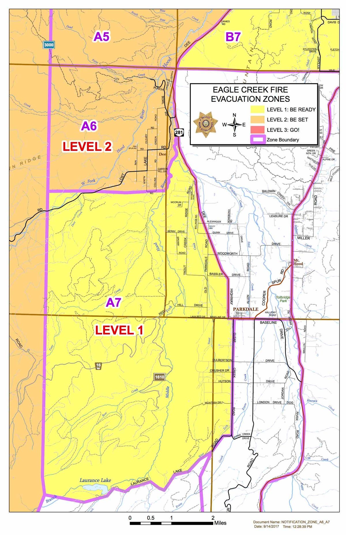
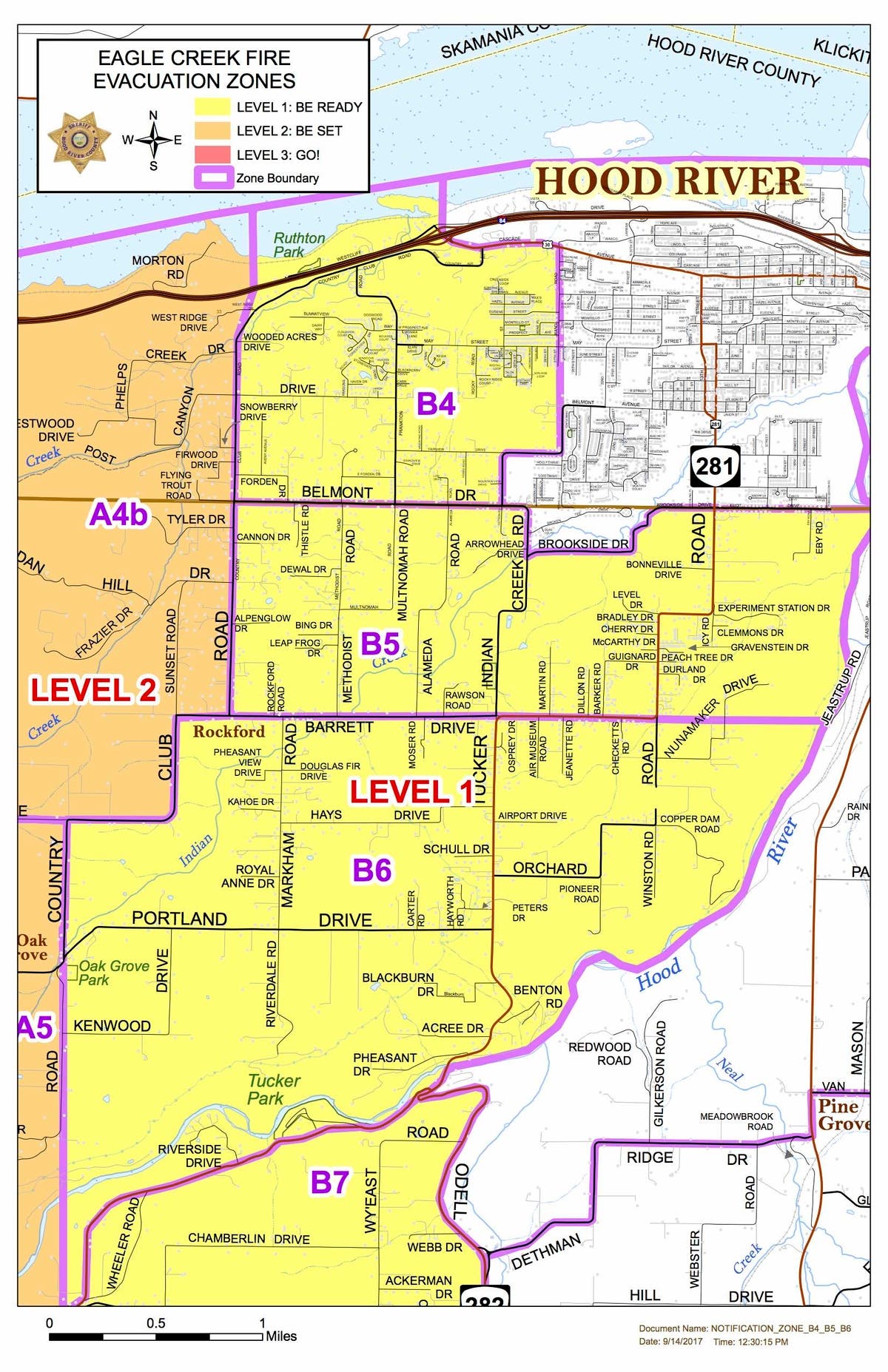
Zones A7, B4, B5, B6 and B7 are now being placed on Level One evacuation notice.
A7: The northern boundary of this zone begins at the intersection of Highway 281 (Dee Highway) and the Middle Fork of the Hood River (Milepost 12.5) and runs down to the south end of Collins Road in Dee. The southern boundary follows Laurance Lake Road from Clear Creek Road out past Laurance Lake. The eastern boundary follows 281 south to Clear Creek and then south to Laurance Lake.
B4: The northern boundary of this zone is the Columbia River and the southern boundary is Belmont Drive. The eastern boundary is Rand Road running down to the May Street intersection. The line then continues due south until it reaches Belmont Drive in the 2600 Block area. The western boundary is Country Club Road.
B5: The northern boundary of this zone uses Belmont, Brookside and Elliot. The southern boundary uses Barrett Drive, running on a straight line through Tucker Road, all the way to the Hood River. The Hood River is the eastern boundary, and Country Club Road is the western boundary.
B6: The northern boundary of this zone uses Barrett Drive running east-west from Country Club to the Hood River. The southern-eastern boundary follows the Hood River until it reaches Highway 281 (Dee Highway), then follows 281 until Summit Drive. The Hood River is the eastern boundary, and the western boundary is defined by Country Club, beginning at the Barrett intersection, then following it south to Reed Road, then following that line due south until it intersects with 281 at Summit.
B7: The north-western boundary of this zone begins at the Highway 281 (Dee Highway) and Highway 282 (Odell Highway) junction and follows 281 down to mile post 10.5. The southern boundary follows a straight line east-west using Central Vale Drive. The eastern boundary follows Highway 282 (Odell Highway) until it reaches Straight Hill Road, south to Massee Grade, then intersecting with Highway 35 until Central Vale Drive.
The Cascade Locks area remains at Level Two notice, and the A4a zone running along the I-84 corridor from Exit 47 to Exit 56 remains at Level Three.
The new alterations, the second batch in two days, were reportedly due to new spot fires that began in Herman Creek and spread to the ridges east of Gorton Creek and Shellrock Mountain, Hood River County officials said.
Multnomah County officials on Wednesday also altered the evacuation levels on the metro region's Eastside:
According to the Multnomah County Sheriff's Office, the following changes have been made:
Level 3 (Go!) evacuation orders are in effect in the areas of:
- Dodson
- Warrendale
- Bridal Veil
- East Historic Columbia River Highway: East of Alex Barr Road, addresses in the 43800 block and higher
- Larch Mountain Road: East of Brower Road, addresses in the 45800 block and higher
- All of Brower Road, including Toll Road
- E Haines Road: addresses in the 43800 block and higher.
Level 2 (Be Set) evacuation orders are in effect in the areas of:
- Latourell
- Larch Mountain Road: West of Brower Road, addresses in the 45700 block and lower, including Salzman Road and Alder Meadows Road
- E Haines Road: addresses in the 43700 block and lower (towards Larch Mountain Road)
- Corbett
- Springdale
- Troutdale: addresses East of the Sandy River
And Level 1 (Get Ready) evacuation notices have been lifted for all areas of Troutdale West of the Sandy River, meaning there currently are no communities in a Level 1 evacuation.
Residents in the areas downgraded from Level 3 to Level 2 are asked to report to a re-entry center located at Corbett Community Church, 34309 N.E. Mershon Rd. in Corbett, sheriff's officials said.
Because residents moving from a Level 3 to a Level 2 are still asked to Be Set, we are requesting that only household pets return with their owners, and that large livestock and horses remain out of these areas until evacuation orders are lifted.
The Sheriff’s Office understands the importance of getting our residents back into their homes and neighborhoods as quickly as possible. Over the coming days, we will continue to work with fire officials to examine possible re-entry into additional portions of the remaining Level 3 communities. For those residents still under a Level 3 evacuation notice, thank you for your continued patience and understanding. Questions regarding evacuations in Multnomah County can be directed to 211. If you are a resident of Hood River County, please continue to monitor updates from the Hood River County Sheriff’s Office. For access to the current evacuation map, please visit multco.us.
Upcoming weather events could be a boon for firefighters
While Friday and Saturday's weather forecasts don't appear likely to offer any relief for firefighting efforts, with light winds and low humidity on the menu, a massive rain storm expected to begin Sunday could help out in a big way.
Related Eagle Creek Fire coverage from Patch:
- Scorched Earth: Time-Lapse Video Shows Rapid Spread Of Eagle Creek Fire
- Former Guardsman, Sex Offender Arrested For Stealing Eagle Creek Firefighter Gear, Police Say
- 'Giggling Kids With Fireworks' Responsible For Eagle Creek Fire, Witness Says
- Eagle Creek Fire Suspect Is 15-Year-Old Washington Boy: Oregon State Police
- Massive Eagle Creek Fire Merged With 1,000-Acre Indian Creek Fire Overnight
Image via Multnomah County Communications, Flickr
Get more local news delivered straight to your inbox. Sign up for free Patch newsletters and alerts.