Community Corner
Eagle Creek Fire: 11 Percent Contained; Burning 35,000 Acres
Transportation crews are working hard to reopen Interstate-84, which will likely see the westbound lanes open first, ODOT officials said.

CASCADE LOCKS, OR — The Eagle Creek Fire is burning 35,000 acres and is 11 percent contained as of Sept. 12, according to the Oregon Fire Marshal, who said Tuesday that weather this week and weekend will play a role in the fire's upcoming behavior.
A pair of community meetings on Monday in Troutdale and Cascade Locks gave fire officials an opportunity to share with affected residents and communities the current state of affairs along the Columbia River Gorge, the fire marshal said. In essence, work on the fire is progressing though changes to weather this week could impact efforts — both in good and bad ways, depending.
While the cool, moist air could lower and moderate fire behavior, wind gusting between 25 and 35 mph could cause an increase, the fire marshal said.
Find out what's happening in Portlandfor free with the latest updates from Patch.
For Tuesday, fire crews will continue work preparing Interstate-84 for reopening by strengthening and holding containment lines, and felling hazardous trees along the I-84 corridor. Fire crews also expect to improve containment lines toward Shell Rock Mountain and secure contingency lines on the fire's east and southeast side, the fire marshal said.
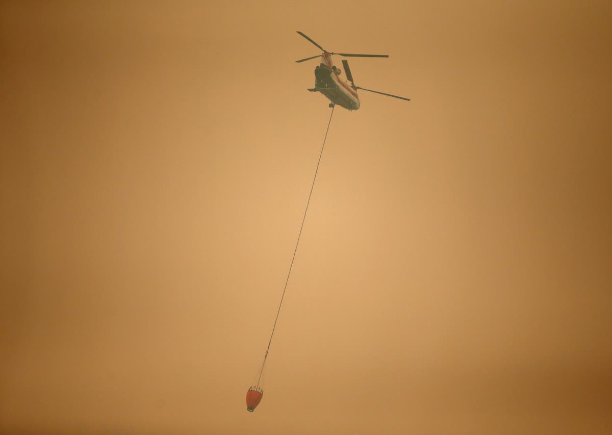
Chinook helicopter bucket drops will continue to cool fire activity in the Herman Creek drainage, the fire marshal said, noting more than 900 people still working the Eagle Creek Fire, including 56 fire engines, 11 helicopters, nine bulldozers and 15 water tenders.
Find out what's happening in Portlandfor free with the latest updates from Patch.
WATCH: Eagle Creek and Indian Creek fires update Sept. 12
Oregon Department of Transportation (ODOT) officials on Monday night announced I-84 will reopen when it's safe.
ODOT crews have already removed roughly 2,500 trees that were posing a hazard to I-84, but nearly 1,000 trees still need to be felled, officials said. The work should be completed within the next few days, but other factors will play a role as to when the interstate can be reopened.
Officials said I-84's westbound lanes will likely reopen first, but all reopening is being held off at least until Cascade Locks is no longer an active evacuation zone. To safely reopen I-84's eastbound lanes, ODOT crews will need to complete rock scaling to prevent slides and other falling rock dangers, and remove burned, hazardous trees, officials said.
"The biggest impediment to re-opening the I-84 eastbound lanes is the threat of falling rocks, mostly around the Toothrock Tunnel," ODOT spokesman Dave Thompson said in an email. "The work is slow in steep, difficult terrain and reaches high up the hillside."
ODOT crews checked 70 bridges in the evacuation area, including the Toothrock Tunnel, and found minimal damage, officials said. Only the Oneonta Tunnel on the historic Columbia River highway appears totally destroyed.
The historic Columbia River highway has no current schedule for reopening, officials said. While firefighters are able to use it, it is still unsafe for commercial traffic.
The American Red Cross continues to assist roughly 170 people affected by the Eagle Creek Fire evacuations.
According to Red Cross officials, about 24 people are staying at the Red Cross shelter setup at Mt. Hood Community College in Gresham, while more than 140 people are staying at the shelter on the Skamania County Fairgrounds in Stevenson, Washington.
According to the Multnomah County Sheriff's Office, all current evacuation levels remain in place:
- Interstate-84 is closed from exit 17 in Troutdale to roughly 2 miles west of Hood River, around milepost 62.
- Multnomah County officials have issued Level 3 (meaning leave right now) evacuations for Larch Mountain and the communities of Bridal Veil, Corbett (east of the 38700 block of Columbia River Highway), Dodson, Latourell and Warrendale.
- Corbett/Springdale, west of 38700 block of the Columbia River Highway to the Sandy River, has been set at Level 2 (meaning be ready to evacuate at a moment's notice).
- Troutdale east of Southeast 257th Avenue and north of Southeast Stark Street has been given Level 1 evacuation orders (meaning get your stuff ready to go).
- Mt. Hood Community College, 3691 N.E. 17th Drive, has been turned into an evacuation shelter for the time being with help from the Red Cross, officials said. Anyone evacuating due to fire is encouraged to go there.
- Hood River County officials raised all previously issued Level 1 notices in Cascade Locks to Level 2, and on Friday added a new Level 1 area around the city of Dee.
- The border of the new Level 1 alert begins south of Dee along Collins Road and moves Northeast all the way to Interstate-84.
- Also on Friday, a Level 2 alert was extended east from the Northeast half of Cascade Locks to Viento State Park along the I-84 corridor. Officials said this includes the In-Lieu site and the whole area of Wyeth.
- Other areas affected by the increase to Level 2 includes all areas north of Wa Na Pa to the Columbia River and on the east end of Hood River north of I-84 to the river, as well as Forest Lane and intersecting roads, running east to Government Cove.
- Level 3 evacuations are in place for all residents south of I-84 in the Cascade Locks. An evacuation shelter is located at the Skamania County Fairgrounds in Stevenson, Washington, across the Columbia River.
Related Eagle Creek Fire coverage on Patch:
- Former Guardsman, Sex Offender Arrested For Stealing Eagle Creek Firefighter Gear, Police Say
- Scorched Earth: Time-Lapse Video Shows Rapid Spread Of Eagle Creek Fire
- Massive Eagle Creek Fire Merged With 1,000-Acre Indian Creek Fire Overnight
- 'Giggling Kids With Fireworks' Responsible For Eagle Creek Fire, Witness Says
- Eagle Creek Fire Suspect Is 15-Year-Old Washington Boy: Oregon State Police
Top Photo: A helicopter with a water bucket flies through dense smoke near Stevenson, Wash., Wednesday, Sept. 6, 2017, as it works to battle the Eagle Creek wildfire on the Oregon side of the Columbia River Gorge. (AP Photo/Randy L. Rasmussen)
Get more local news delivered straight to your inbox. Sign up for free Patch newsletters and alerts.