Weather
Severe Thunderstorm Watch Issued Across Eastern PA
Forecasters said storms could be severe, with wind that could potentially bring down power lines and trees.

Update: A severe thunderstorm watch has been issued across Eastern Pennsylvania until 10 p.m. Tuesday.
The watch is in place across the region, including in Bucks, Chester, Delaware, Montgomery and Philadelphia counties. It also includes Adams, Berks, Carbon, Dauphin, Lackawanna, Lancaster, Lebanon, Lehigh, Luzerne, Monroe, Northampton, Pike, Schuylkill, Wayne, Wyoming and York counties.
Original story:
Find out what's happening in Across Pennsylvaniafor free with the latest updates from Patch.
EASTERN PA — The next rounds of thunderstorms could arrive to the Delaware Valley by Tuesday night, bringing potentially heavy rainfall and flooding, according to forecasters.
There are two separate fronts which offer the greatest risk: one which will arrive around 2 p.m. Tuesday and continue until 10 p.m. Tuesday night, and another which will arrive 4 p.m. Wednesday and continue until 2 a.m. Thursday.
Find out what's happening in Across Pennsylvaniafor free with the latest updates from Patch.
All of southeastern Pennsylvania is within the highest risk area for this storm, according to the National Weather Service.
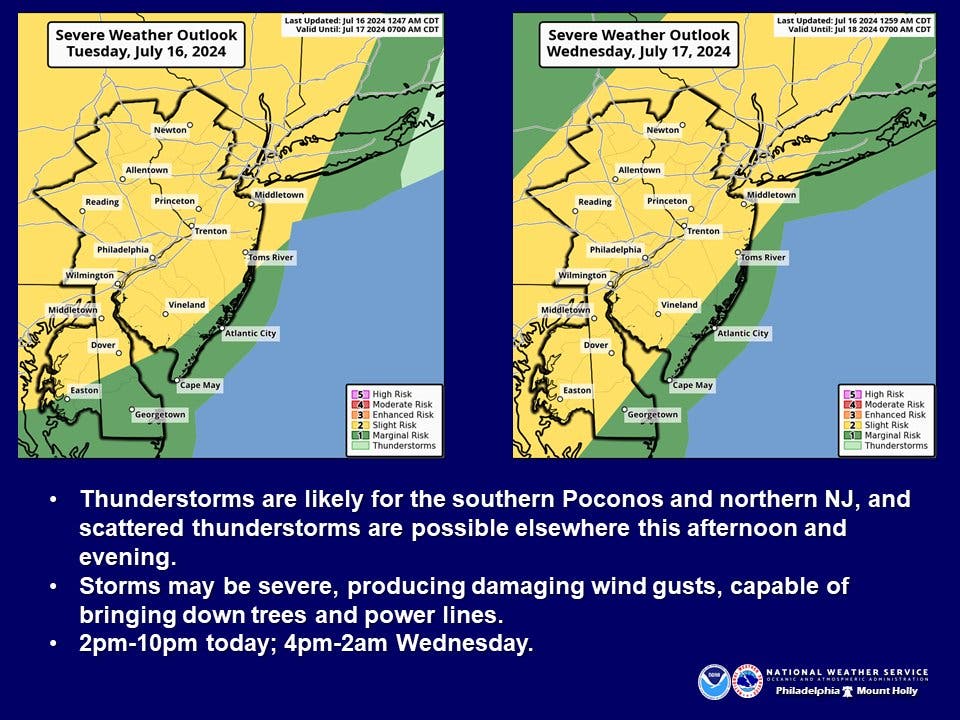
Heavy rainfall will occur within thunderstorms, and damaging wind gusts could bring down trees and power lines, officials warned.
Severe weather is likely to clear after Thursday, with a hot and clear weekend currently on tap.
Here's the full forecast for the coming week:
Tuesday
Sunny and hot, with a high near 100. Heat index values as high as 107. Southwest wind 5 to 15 mph.
Tuesday Night
A chance of showers and thunderstorms, mainly before 1 a.m. Some of the storms could produce heavy rainfall. Mostly cloudy, with a low around 78. Southwest wind 5 to 10 mph. Chance of precipitation is 30 percent. New rainfall amounts of less than a tenth of an inch, except higher amounts possible in thunderstorms.
Wednesday
Showers and thunderstorms likely, mainly after 2 p.m. Mostly sunny, with a high near 96. Heat index values as high as 105. Southwest wind 5 to 10 mph. Chance of precipitation is 60 percent. New rainfall amounts between a tenth and quarter of an inch, except higher amounts possible in thunderstorms.
Wednesday Night
Showers and thunderstorms likely before 2 a.m., then showers likely and possibly a thunderstorm after 2 a.m. Mostly cloudy, with a low around 75. Southwest wind around 5 mph. Chance of precipitation is 70 percent. New rainfall amounts between a quarter and half of an inch possible.
Thursday
A chance of showers and thunderstorms, mainly after 2 p.m. Partly sunny, with a high near 86. Northwest wind around 5 mph. Chance of precipitation is 30 percent. New rainfall amounts of less than a tenth of an inch, except higher amounts possible in thunderstorms.
Thursday Night
A chance of showers and thunderstorms before 8 p.m. Partly cloudy, with a low around 69. Chance of precipitation is 30%.
Friday
Sunny, with a high near 87.
Friday Night
Partly cloudy, with a low around 68
Get more local news delivered straight to your inbox. Sign up for free Patch newsletters and alerts.


