Weather
2 Rounds Of Severe Thunderstorms, Heavy Rain To Hit Eastern PA
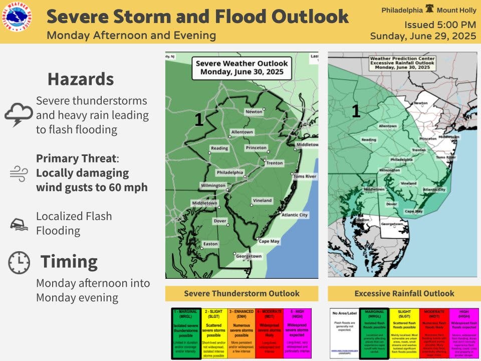
Wind gusts up to 60 miles per hour and flash flooding are possible, forecasters said.

Torrential rain and severe thunderstorms could lead to flooding in the greater Philadelphia area over the next two days, according to the National Weather Service said.
The first round of storms will arrive in the afternoon Monday, mainly after 2 p.m., forecasters said.
Forecasters gave a 30 to 50 percent chance of thunderstorms through the evening.
Find out what's happening in Across Pennsylvaniafor free with the latest updates from Patch.
"Scattered thunderstorms will be capable of producing very heavy rainfall that could lead to localized flash flooding and locally damaging wind gusts," the National Weather Service's Mt. Holly, New Jersey branch said.
Gusts could be as high as 60 miles per hour, authorities said, bringing down trees and power lines and causing significant power outages.
Find out what's happening in Across Pennsylvaniafor free with the latest updates from Patch.
"Flooding downpours, hail and damaging wind gusts will be the primary threats in any severe thunderstorm that erupts," AccuWeather meteorologist Peyton Simmers said. "These thunderstorms can slow down the evening commute along parts of the I-95 corridor including in New York City, Philadelphia and Washington, D.C."
On Tuesday, the second round of storms has an even higher likelihood of causing widespread impacts around the region, with a 70 to 90 percent chance, officials said.
Rain will continue into the early morning Tuesday before thunderstorms arrive again in the early afternoon.
All of the five-county greater Philadelphia area is within the National Weather Service's "slight" risk of severe impacts on Tuesday, an increase over the "marginal" category on Monday.
Up to half an inch of rain could fall on both afternoons and evenings.

Here's the full forecast, according to the National Weather Service:
Monday
Showers and thunderstorms likely, mainly after 2 p.m. Partly sunny, with a high near 91. Calm wind becoming south around 5 mph in the afternoon. Chance of precipitation is 60 percent. New rainfall amounts between a quarter and half of an inch possible.
Monday Night
A chance of showers and thunderstorms before 5 a.m., then a slight chance of showers. Mostly cloudy, with a low around 76. South wind around 5 mph. Chance of precipitation is 50 percent. New rainfall amounts between a half and three quarters of an inch possible.
Tuesday
A chance of showers before 11 a.m., then a chance of showers and thunderstorms between 11 a.m. and 2 p.m., then showers and possibly a thunderstorm after 2 p.m. High near 91. Southwest wind 10 to 15 mph. Chance of precipitation is 90 percent. New rainfall amounts between a quarter and half of an inch possible.
Tuesday Night
Showers and possibly a thunderstorm, mainly before 2 a.m., then a chance of showers and thunderstorms after 2 a.m. Low around 72. Southwest wind 5 to 10 mph, with gusts as high as 20 mph. Chance of precipitation is 80 percent. New rainfall amounts between a quarter and half of an inch possible.
Wednesday
A chance of showers before 8 am. Mostly sunny, with a high near 87. Northwest wind around 5 mph. Chance of precipitation is 30 percent.
Wednesday Night
Mostly clear, with a low around 70.
Thursday
Sunny, with a high near 88.
Thursday Night
Mostly clear, with a low around 69.
Independence Day
Sunny, with a high near 83.
Friday Night
Mostly clear, with a low around 65.
Get more local news delivered straight to your inbox. Sign up for free Patch newsletters and alerts.


