Weather
-20 Wind Chills, Snow Squalls In Brutal Weekend Forecast, Warnings Issued For PA
Residents across the region are bracing for what forecasters say could be one of the coldest weekends in a while.

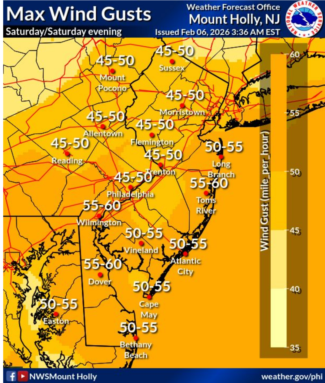
Residents across the region are bracing for what forecasters say could be one of the coldest weekends in a while. Winds on Saturday could gust as high as 60 mph in the region, coupled with temperatures dropping to the single digits by 5 p.m. Plus, some snow squalls could be mixed in.
Warnings, Advisories In Place
An Extreme Cold Warning and a Wind Advisory have been announced in the region. Residents should anticipate very cold temperatures and strong winds through Saturday night and into Sunday morning.
The Extreme Cold Warning is in effect for the entire area, including southeastern Pennsylvania, starting Saturday and continuing into Sunday morning at 10 a.m. A Wind Advisory will also be in place from 8 a.m. to 9 p.m. Saturday, with winds expected to increase to 20 to 35 mph. Gusts could be as high as 40 to 60 mph across the region.
Find out what's happening in Across Pennsylvaniafor free with the latest updates from Patch.
Snow Possible
Light accumulating snowfall is possible Friday evening, spreading across the region from northwest to southeast. Snowfall is expected to largely end around 7 a.m. Saturday. There is a 40 to 70 percent chance of snow from the evening through overnight.
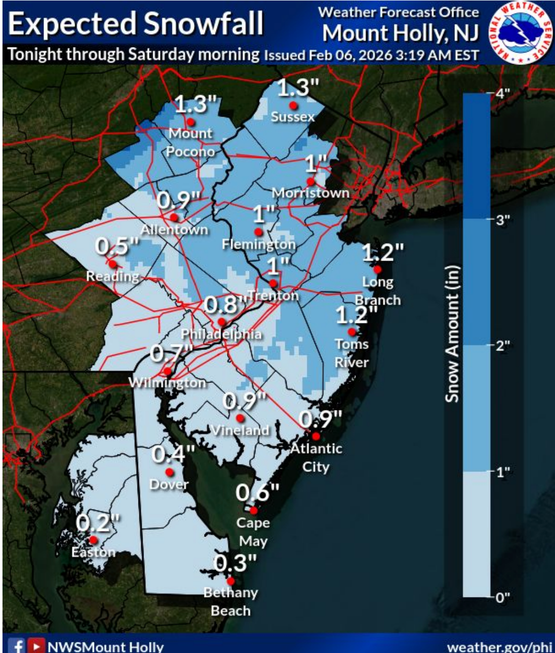
Accumulation estimates are expected to be an inch or less. However, a brief period of heavier snow showers or squalls is possible early Saturday morning around dawn, forecasters said.
Find out what's happening in Across Pennsylvaniafor free with the latest updates from Patch.
Despite the light accumulations, gusty winds and low visibilities within any snow squalls could lead to dangerous travel conditions, forecasters warn.
Strong Winds Anticipated
The combination of very cold air temperatures and strong winds will result in very dangerous wind chills of -10° to -20°, with values potentially reaching as low as -25° in the Poconos from Saturday through Sunday morning.
Winds will gradually diminish late Saturday night through Sunday.
Scattered power outages and tree damage are possible due to the high winds, forecasters warn.
Here's the local forecast:
Today: Mostly cloudy, with a high near 30. Calm wind becoming southwest around 5 mph.
Tonight: A chance of snow, mainly after 7pm. Cloudy, with a low around 12. Light southwest wind becoming west 5 to 10 mph after midnight. Winds could gust as high as 20 mph. Chance of precipitation is 50%. New snow accumulation of around an inch possible.
Saturday: Cloudy, then gradually becoming mostly sunny, with a temperature falling to around 9 by 5pm. Wind chill values as low as -11. Blustery, with a northwest wind 20 to 25 mph, with gusts as high as 50 mph.
Saturday Night: Mostly clear, with a low around 3. Wind chill values as low as -15. Blustery, with a northwest wind 15 to 20 mph, with gusts as high as 45 mph.
Sunday: Sunny, with a high near 19. Northwest wind 10 to 15 mph, with gusts as high as 30 mph.
Sunday Night: Mostly clear, with a low around 3.
Monday: Partly sunny, with a high near 25.
Monday Night: Partly cloudy, with a low around 12.
Tuesday: Mostly sunny, with a high near 32.
Tuesday Night: A chance of snow and freezing rain after 1am. Partly cloudy, with a low around 19. Chance of precipitation is 30%.
Wednesday: A chance of rain or freezing rain. Mostly cloudy, with a high near 36. Chance of precipitation is 40%.
Wednesday Night: A chance of rain. Mostly cloudy, with a low around 21. Chance of precipitation is 30%.
Thursday: Partly sunny, with a high near 32.
Get more local news delivered straight to your inbox. Sign up for free Patch newsletters and alerts.