Weather
6 Inches Of Snow Possible For Philly Area In Weekend Storm: Latest Updates
The chances of significant accumulating "continue to increase," forecasters said.

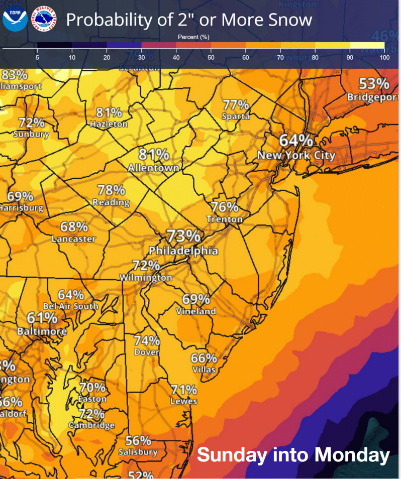
The chance for accumulating snow in the coming winter storm "continues to increase" in the Philadelphia area, the National Weather Service said, with anywhere from two to six inches or more possible.
The storm will arrive late Saturday night into early Sunday, and may begin as rain, according to forecasters.
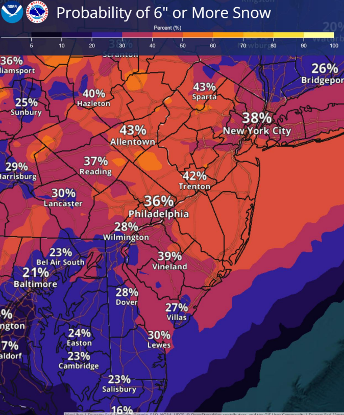
Temperatures will drop in the evening hours Sunday and that's when snow could begin to accumulate. The National Weather Service gives a 73 percent chance of at least two inches or more of snow, while there's anywhere from a 20 to a 40 percent chance of six inches or more.
Find out what's happening in Across Pennsylvaniafor free with the latest updates from Patch.
Total accumulation is still variable, as the final track of the storm is not yet certain. Forecasters warn that there's a chance the front could shift into a "bomb cyclone," where a storm undergoes a rapid intensification due to a massive drop in atmospheric pressure.
"Not only will the storm evolve into a significant nor'easter with strong winds and heavy snow along parts of the Atlantic coast, but it may become a bomb cyclone as it begins to move away," Accuweather Senior Meteorologist Chad Merrill said.
Find out what's happening in Across Pennsylvaniafor free with the latest updates from Patch.
If the storm tracks farther to the east, lower snowfall totals are more likely, as this will cause the storm to strengthen too late for it to have major impacts, forecasters said.
However, if the storm does undergo a quick transformation into a bomb cyclone, it could bring heavier snow and winds to the region, bringing six inches or more of accumulation.
Regardless of the final totals, it appears likely that there will be notable impacts to travel come Monday morning, with the potential for delays on the roads and at airports.
Temperatures will remain mostly mild in the days leading up to the storm. Friday will see a high of 46, with some rain likely during the day. Highs will reach 49 Saturday before stormy conditions arrive later in the evening.
Here's the full forecast for the Philadelphia area for the coming week, according to the National Weather Service:
Today
Rain, mainly before 11 a.m. Patchy fog between noon and 2 p.m. High near 46. Northeast wind around 5 mph. Chance of precipitation is 90 percent. New precipitation amounts between a tenth and quarter of an inch possible.
Tonight
Mostly cloudy, with a low around 37. North wind around 5 mph becoming west after midnight.
Saturday
Partly sunny, with a high near 49. Northwest wind 5 to 10 mph.
Saturday Night
A chance of rain after 1 a.m, mixing with snow after 4 a.m. Increasing clouds, with a low around 34. Calm wind. Chance of precipitation is 30 percent. Little or no snow accumulation expected.
Sunday
Rain and snow before 1 p.m., then rain between 1 p.m. and 4 p.m., then snow, possibly mixed with rain after 4 p.m. High near 40. Northeast wind 5 to 10 mph. Chance of precipitation is 90 percent. New snow accumulation of less than a half inch possible.
Sunday Night
Snow, possibly mixed with rain, becoming all snow after 7 p.m. Low around 31. Chance of precipitation is 80 percent. New precipitation amounts between a quarter and half of an inch possible.
Monday
A chance of snow before 1 p.m. Cloudy, with a high near 38. Chance of precipitation is 30 percent.
Monday Night
Mostly cloudy, with a low around 26.
Tuesday
Mostly sunny, with a high near 37.
Tuesday Night
Mostly cloudy, with a low around 23.
Wednesday
Mostly cloudy, with a high near 42.
Wednesday Night
A chance of rain. Mostly cloudy, with a low around 36. Chance of precipitation is 50 percent.
Thursday
A chance of rain. Mostly cloudy, with a high near 49. Chance of precipitation is 40 percent.
Get more local news delivered straight to your inbox. Sign up for free Patch newsletters and alerts.


