Weather
Severe Weather, Possible Tornado In Wednesday Evening Forecast For Eastern PA: NWS
The most severe impacts are expected between 3 p.m. and 10 p.m. for the Philadelphia region, forecasters said.

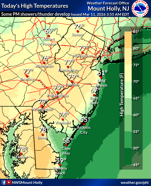
After a 43-degree temperature swing in parts of the greater Philadelphia area Tuesday, some unsettled weather is anticipated Wednesday, forecasters said.
Severe thunderstorms capable of damaging winds, large hail, and an isolated tornado are possible this afternoon and evening as a powerful cold front hits the very warm air currently sitting over the region, according to the National Weather Service.
"The severe weather risk will depend on how quickly storms arrive and their coverage," the National Weather Service's Mt. Holly, New Jersey station warned. "Stay weather aware."
Find out what's happening in Across Pennsylvaniafor free with the latest updates from Patch.
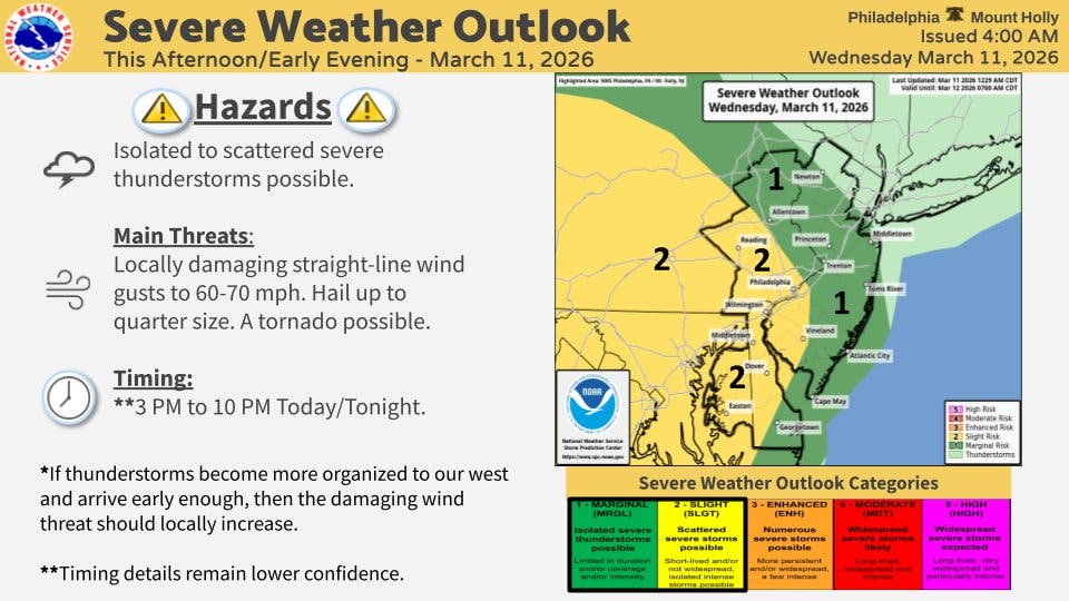
Showers are possible throughout the day, with thunderstorms arriving after 5 p.m. Wednesday. Severe weather will continue into the evening hours and overnight into Thursday.
The most severe impacts are expected between 3 p.m. and 10 p.m.
Find out what's happening in Across Pennsylvaniafor free with the latest updates from Patch.
Power outages and downed trees are possible.
The storm will follow near record temperatures again on Wednesday, with highs soaring near 80 degrees.
The cold front carrying the storm will bring low temperatures down to 33 by Thursday night, forecasters said.
Tuesday's "diurnal temperature range" was 43 degrees, with a high of 83 and a low of 40, the National Weather Service said, the 8th largest range record for the greater Philadelphia area.
Here's the full forecast for the coming week, according to the National Weather Service:
Wednesday
A chance of showers, with thunderstorms also possible after 5 p.m. Mostly cloudy, with a high near 79. South wind 5 to 15 mph. Chance of precipitation is 30 percent. New rainfall amounts between a tenth and quarter of an inch, except higher amounts possible in thunderstorms.
Wednesday Night
A chance of showers and thunderstorms, then showers likely and possibly a thunderstorm after 5 a.m. Mostly cloudy, with a low around 52. South wind 10 to 15 mph, with gusts as high as 30 mph. Chance of precipitation is 60 percent. New rainfall amounts between a tenth and quarter of an inch, except higher amounts possible in thunderstorms.
Thursday
Showers likely, mainly before 8 a.m. Cloudy, with a temperature falling to around 45 by 2 p.m. Breezy, with a northwest wind around 20 mph, with gusts as high as 30 mph. Chance of precipitation is 60 percent. New precipitation amounts between a tenth and quarter of an inch possible.
Thursday Night
Mostly cloudy, then gradually becoming clear, with a low around 33. West wind 5 to 10 mph.
Friday
Partly sunny, with a high near 51. South wind 5 to 10 mph increasing to 10 to 15 mph in the afternoon. Winds could gust as high as 30 mph.
Friday Night
Partly cloudy, with a low around 40.
Saturday
Sunny, with a high near 52.
Saturday Night
Mostly cloudy, with a low around 37.
Sunday
Cloudy, with a high near 56.
Sunday Night
Rain, mainly after 2 a.m. Low around 49. Chance of precipitation is 90 percent.
Monday
Rain. High near 63. Chance of precipitation is 80 percent.
Monday Night
Rain and snow likely. Partly cloudy, with a low around 30. Chance of precipitation is 60 percent.
Tuesday
Mostly sunny, with a high near 39.
Get more local news delivered straight to your inbox. Sign up for free Patch newsletters and alerts.


