Weather
Another Extreme Weather Week For Eastern PA: Latest On Storms, Heat
As the heat index rises to 108, there are several more chances for severe thunderstorms and 60 mile per hour wind gusts this week.


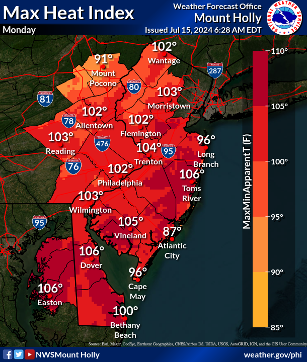
EASTERN PA — Another week of bizarre and extreme weather looks to be on tap for the greater Philadelphia region, with dangerous heat indexes rising over 102 degrees and multiple chances for heavy rain and thunderstorms.
Heavy downpours and damaging wind gusts will arrive Monday afternoon and linger through the evening, the National Weather Service said.
While southeastern Pennsylvania is outside of the highest risk zone, which is focused in northeastern Pennsylvania and northwestern New Jersey, the area still has a good chance to see some severe weather impacts.
Find out what's happening in Across Pennsylvaniafor free with the latest updates from Patch.

Wind gusts up to 60 miles an hour could batter the area, and while just a small amount of rain is forecasted, that could balloon to an inch or more where localized thunderstorms hit.
Before, after, and between storms, the heat will be severe. The heat index is forecasted to be over 100 degrees throughout the area. The region is under "excessive heat warning" until 6 a.m. Wednesday, with "dangerously hot conditions" and heat indexes up to 108 degrees in the forecast.
Find out what's happening in Across Pennsylvaniafor free with the latest updates from Patch.
Tuesday will be the hottest day, with the index soaring to 108 degrees. Temperatures will remain in the upper 90s Wednesday before slightly cooling Thursday with the next bout of storms.
While there is a slight chance of rain and thunder Wednesday, they're most likely to arrive Wednesday night before 11 p.m., the National Weather Service said.
The stormy weather will clear out by the end of the week, with clear and sunny skies forecasted for next week.
Here's the full forecast:
Monday
A chance of showers and thunderstorms, mainly after 5 p.m. Some of the storms could produce heavy rainfall. Mostly sunny and hot, with a high near 97. Heat index values as high as 102. West wind 10 to 15 mph. Chance of precipitation is 30 percent. New rainfall amounts of less than a tenth of an inch, except higher amounts possible in thunderstorms.
Monday Night
A chance of showers and thunderstorms, mainly before 10 p.m. Some of the storms could produce heavy rainfall. Partly cloudy, with a low around 77. Southwest wind around 5 mph. Chance of precipitation is 30 percent. New precipitation amounts of less than a tenth of an inch, except higher amounts possible in thunderstorms.
Tuesday
Sunny and hot, with a high near 100. Heat index values as high as 108. Southwest wind 5 to 10 mph.
Tuesday Night
A slight chance of showers and thunderstorms before 2 a.m. Partly cloudy, with a low around 80. Southwest wind 5 to 10 mph. Chance of precipitation is 20 percent.
Wednesday
A slight chance of showers, then a chance of showers and thunderstorms after 11 a.m. Mostly sunny, with a high near 95. West wind 5 to 10 mph. Chance of precipitation is 50 percent. New rainfall amounts between a quarter and half of an inch possible.
Wednesday Night
Showers and thunderstorms likely before 11 p.m., then showers likely and possibly a thunderstorm between 11 p.m. and 2 a.m., then a chance of showers and thunderstorms after 2am. Mostly cloudy, with a low around 76. Chance of precipitation is 70 percent. New rainfall amounts between a half and three quarters of an inch possible.
Thursday
A chance of showers before 2 p.m. Partly sunny, with a high near 85. Chance of precipitation is 30 percent.
Thursday Night
Partly cloudy, with a low around 67
Get more local news delivered straight to your inbox. Sign up for free Patch newsletters and alerts.