Weather
Another Multi-Day Rainstorm To Hit Eastern PA
The prolonged storm could lead to flooding later in the week. Details:

EASTERN PA — Rain is on the way to Pennsylvania on Christmas Day, bringing possible flooding and a struggle on the roadways after a morning of dangerously dense fog.
Forecasters with the National Weather Service say the state is in for wet weather for the rest of the week, but the heaviest rain is anticipated to arrive late Tuesday into Wednesday.
Rain is likely to begin at around noon in the greater Philadelphia area, and will continue until around 5 p.m., forecasters said.
Find out what's happening in Across Pennsylvaniafor free with the latest updates from Patch.
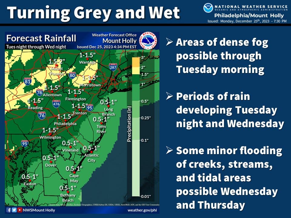
Up to 1.5 inches could fall throughout southeastern Pennsylvania.
Temperatures will remain mild, with highs in the low 50s Tuesday and Wednesday, dropping into the low 40s at night. Winds are also expected to be mild, at 5 mph, so this will not be a repeat of the pair of powerful storms earlier in December that brought destructive wind gusts over 50 miles an hour to parts of the region.
Find out what's happening in Across Pennsylvaniafor free with the latest updates from Patch.
"Meteorologists do not expect this storm to unleash as much rain as prior systems this December in the East, the antecedent wet conditions could result in renewed flooding in some cases," Accuweather said.
Flooding of creeks and rivers could occur later Wednesday into Thursday.
Here's the full forecast for the Philadelphia area, according to the National Weather Service:
Christmas Day
A chance of rain, mainly between noon and 5pm. Cloudy, with a high near 51. East wind around 5 mph. Chance of precipitation is 30%.
Christmas night
A chance of rain, mainly after 3am. Patchy fog before 8pm, then patchy fog after 9pm. Otherwise, cloudy, with a low around 44. East wind around 5 mph. Chance of precipitation is 30%. New precipitation amounts of less than a tenth of an inch possible.
Wednesday
Rain, mainly after 7 a.m. Areas of fog before 1pm. High near 55. East wind 5 to 10 mph. Chance of precipitation is 100 percent. New precipitation amounts between a quarter and half of an inch possible.
Wednesday night
Rain, mainly before 1 a.m. Patchy fog before 1am. Low around 46. East wind 5 to 10 mph becoming northwest after midnight. Chance of precipitation is 80 pcercent. New precipitation amounts between three quarters and one inch possible.
Thursday
A chance of showers, mainly before 1pm. Partly sunny, with a high near 54. West wind 5 to 10 mph. Chance of precipitation is 30 percent. New precipitation amounts of less than a tenth of an inch possible.
Thursday night
A chance of showers. Mostly cloudy, with a low around 43. Chance of precipitation is 40%. New precipitation amounts of less than a tenth of an inch possible.
Friday
Showers likely, mainly after 1pm. Mostly cloudy, with a high near 51. Chance of precipitation is 60 percent.
Friday night
A chance of showers before 1am. Mostly cloudy, with a low around 37. Chance of precipitation is 40 percent.
Saturday
Mostly sunny, with a high near 44.
Saturday night
Mostly clear, with a low around 29.
Sunday
Mostly sunny, with a high near 42.
Sunday night
Partly cloudy, with a low around 31.
New Year's Day
Partly sunny, with a high near 44.
Get more local news delivered straight to your inbox. Sign up for free Patch newsletters and alerts.


