Weather
Another Snow Threat In PA Forecast As Bitter Cold, Winds Linger
While powerful wind gusts blast frigid air across the region Tuesday, another major winter storm could be forming, forecasters said.


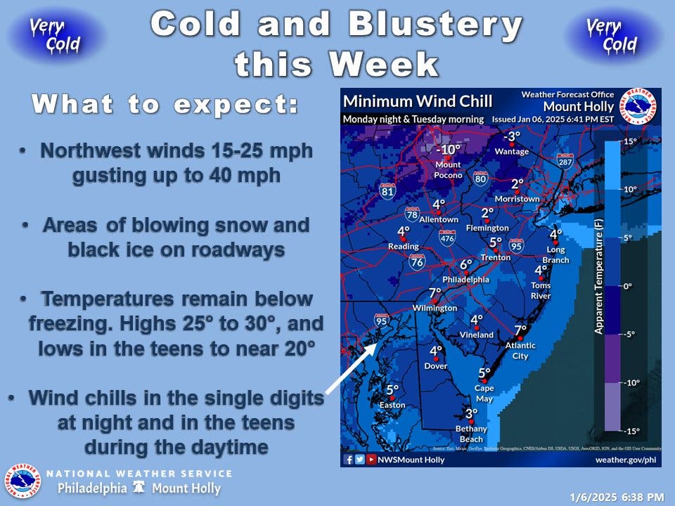
SOUTHEASTERN PA — Bitterly cold air will settle into the greater Philadelphia area this week, freezing some of the already fallen snow and causing travel hazards even as the region prepares for the potential of another storm.
Powerful wind gusts Tuesday, up to 40 miles per hour, will plunge the wind chill down into the single digits and possibly even near zero for much of the day.
Up to 2 inches of snow fell throughout southeastern Pennsylvania in the recent storm. While no new snow will fall on Tuesday, the wind will blow snow and could hamper visibility on the icy roads, the National Weather Service said.
Find out what's happening in Across Pennsylvaniafor free with the latest updates from Patch.
Frigid but dry weather will persist through most of the week, but a second winter storm is threatening from the south and midwest, and could impact the area late Friday into Saturday. However, it depends entirely on what path it takes.
"These scenarios range from the storm continuing on nearly straight to the east with little (or no) snow reaching the central Appalachians and upper mid-Atlantic to a storm strengthening and turning northward with an extensive zone of major snow and ice reaching through the mid-Atlantic and into southeastern New England from Saturday to early Sunday," said AccuWeather meteorologist Paul Pastelok.
Find out what's happening in Across Pennsylvaniafor free with the latest updates from Patch.
Under Accuweather's two proposed scenarios, the storm could either be faster moving and weaker, which would mean it lingers in the area for less time and accumulation is minimal, or slower moving and stronger. In the latter scenario, there is the possibility for "significant" accumulations, forecasters said.
Travel impacts are likely under either scenario.
Here's the full forecast from the National Weather Service:
Tuesday
Areas of blowing snow. Mostly sunny, with a high near 32. Breezy, with a northwest wind 15 to 20 mph, with gusts as high as 30 mph.
Tuesday Night
Increasing clouds, with a low around 21. Northwest wind around 15 mph, with gusts as high as 25 mph.
Wednesday
Mostly sunny, with a high near 31. West wind 10 to 15 mph, with gusts as high as 25 mph.
Wednesday Night
Mostly clear, with a low around 18. Northwest wind around 10 mph, with gusts as high as 20 mph.
Thursday
Sunny, with a high near 33. Northwest wind 10 to 15 mph, with gusts as high as 30 mph.
Thursday Night
Mostly clear, with a low around 23.
Friday
Mostly sunny, with a high near 37.
Friday Night
A chance of snow after 1am. Mostly cloudy, with a low around 26. Chance of precipitation is 40 percent.
Saturday
A chance of snow. Mostly cloudy, with a high near 35. Chance of precipitation is 30 percent.
Saturday Night
Partly cloudy, with a low around 25.
Sunday
Sunny, with a high near 37.
Sunday Night
Partly cloudy, with a low around 23.
Get more local news delivered straight to your inbox. Sign up for free Patch newsletters and alerts.


