Weather
Severe Thunderstorm Watch Issued In Eastern PA
Damaging wind gusts up to 70 miles per hour, quarter-size hail, and frequent lightning are all possible, forecasters warned.

PENNSYLVANIA — A severe thunderstorm watch was issued for all of southeastern Pennsylvania Wednesday until 7 p.m., the National Weather Service announced.
Damaging wind gusts up to 70 miles per hour, quarter-size hail, and frequent lightning are all possible, forecasters warned.
Delaware, Maryland, New Jersey, and Virginia are also included in the severe thunderstorm watch.
Find out what's happening in Across Pennsylvaniafor free with the latest updates from Patch.
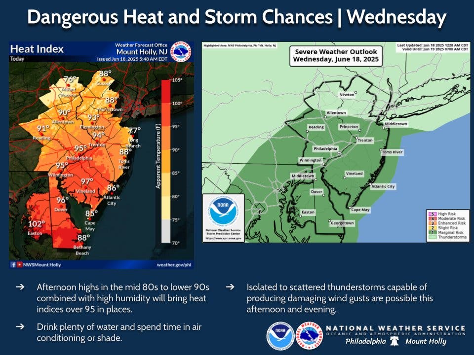
The storms follow a day of dangerous heat and high humidity in much of the area.
A second round of storms is anticipated on Thursday, as well, forecasters said.
Find out what's happening in Across Pennsylvaniafor free with the latest updates from Patch.
Temperatures will soar into the mid to upper 90s in parts of the area Wednesday afternoon, with the heat index approaching or exceeding 100, according to forecasters. The approaching storm will add significant humidity.
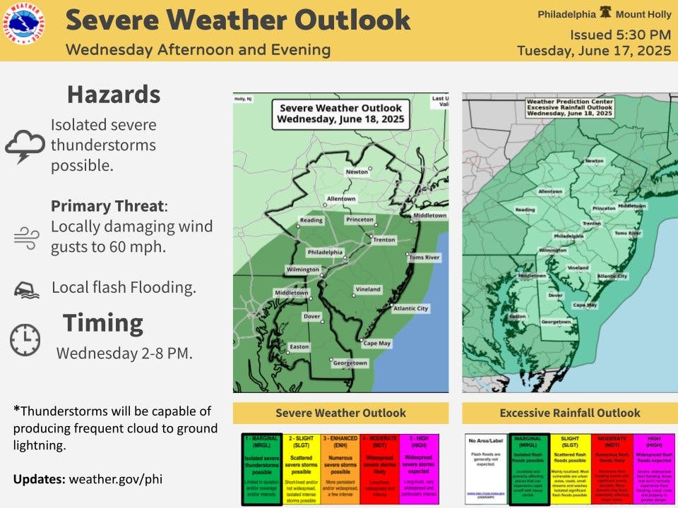
The greatest threat from the storm Wednesday will be in the early afternoon into the evening, from about 5 p.m. to 8 p.m., the National Weather Service said.
Wind gusts up to 60 miles per hour are possible, and torrential rain could bring flash flooding to flood prone areas, according to forecasters.
"The primary concern will be damaging wind gusts," the National Weather Service's Mt. Holly, New Jersey branch. "Some localized flash flooding is also possible Wednesday."
Forecasters added that the unique conditions of the storm front, including the high heat and abundance of moisture in the area, could create severe impacts.
"Similar setups in the past have produced long-lived, damaging thunderstorm wind events, called derechos," Accuweather said.
Potentially severe storms will return again on Thursday afternoon at around 2 p.m., the National Weather Service said, with the threat continuing until around 11 p.m. There's a possibility of thunderstorms continuing into the night until around 2 a.m.
Rainfall will likely be heavier in the night, with about a quarter of an inch forecasted for the day hours and three quarters of an inch predicted for the evening. Flooding is again possible.
Here's the full forecast, according to the National Weather Service:
Wednesday
Showers and thunderstorms likely, then showers and possibly a thunderstorm after 5 p.m. High near 88. Southwest wind 5 to 10 mph. Chance of precipitation is 80 percent. New rainfall amounts of less than a tenth of an inch, except higher amounts possible in thunderstorms.
Wednesday Night
Showers and thunderstorms likely, mainly before 8 p.m. Mostly cloudy, with a low around 74. Southwest wind around 5 mph. Chance of precipitation is 60 percent. New precipitation amounts of less than a tenth of an inch, except higher amounts possible in thunderstorms.
Thursday
Showers and thunderstorms likely after 2 p.m. Some of the storms could be severe. Mostly sunny, with a high near 93. Southwest wind 5 to 15 mph, with gusts as high as 25 mph. Chance of precipitation is 70 percent. New rainfall amounts between a tenth and quarter of an inch, except higher amounts possible in thunderstorms.
Thursday Night
Showers and thunderstorms likely before 11 p.m, then a chance of showers between 11 p.m and 2 a.m. Some of the storms could be severe. Mostly cloudy, then gradually becoming mostly clear, with a low around 67. Southwest wind 5 to 10 mph. Chance of precipitation is 60 percent. New precipitation amounts between a half and three quarters of an inch possible.
Friday
Sunny, with a high near 84. Northwest wind 5 to 10 mph.
Friday Night
Mostly clear, with a low around 66.
Saturday
Sunny, with a high near 89.
Saturday Night
Partly cloudy, with a low around 71.
Sunday
Mostly sunny, with a high near 92.
Sunday Night
Partly cloudy, with a low around 75.
Get more local news delivered straight to your inbox. Sign up for free Patch newsletters and alerts.


