Weather
Timeline For Storms, Hail In Eastern PA Wednesday
Dangerous heat and humidity could give way to severe weather this afternoon and evening, forecasters said.

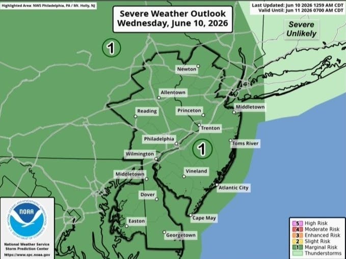
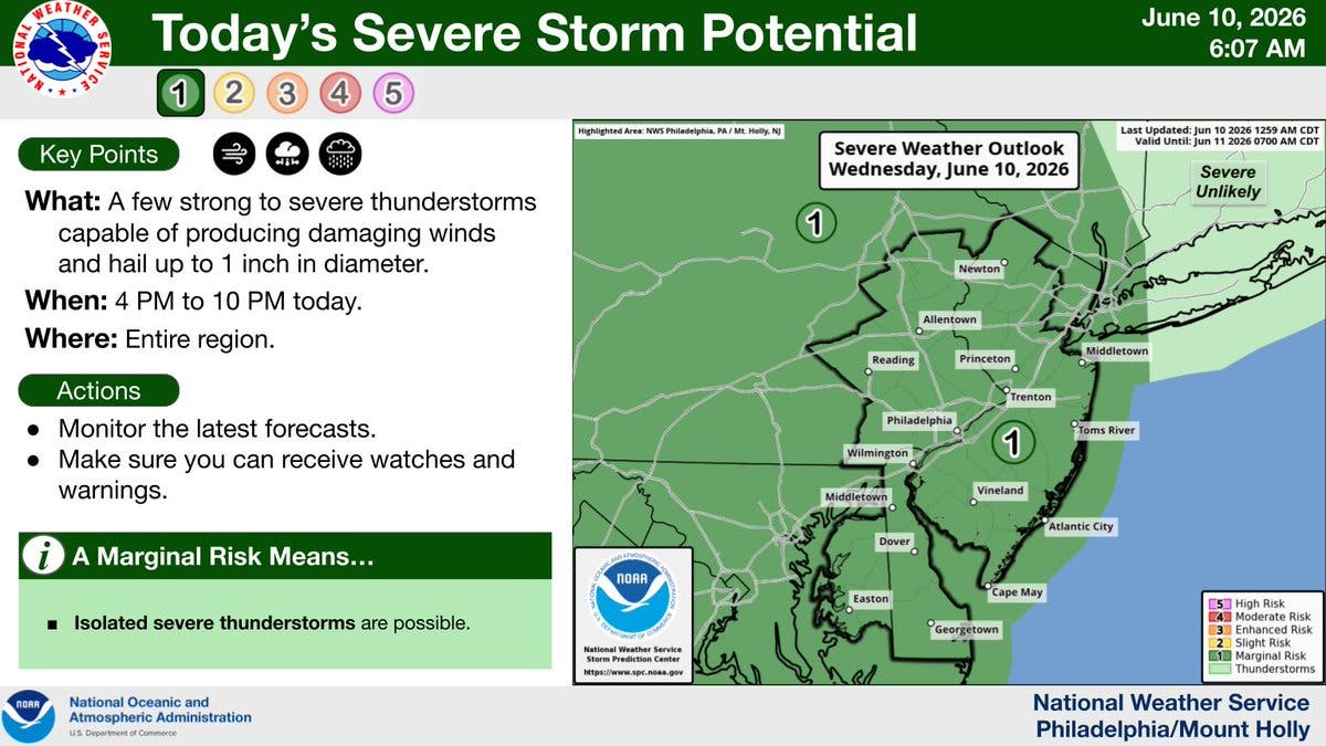
A few thunderstorms capable of producing hail and damaging winds could hit the greater Philadelphia area Wednesday, the National Weather Service said.
Hail could grow up to an inch in diameter. Forecasters characterized the storms as "strong to severe," though the overall risk potential remains in the agency's "marginal" category.
Storms could arrive as early as 4 p.m., and could persist until 10 p.m.. Less than a quarter inch of rain is expected through the evening, though localized higher amounts are possible in thunderstorms.
Find out what's happening in Across Pennsylvaniafor free with the latest updates from Patch.
The inclement weather will follow a burst of potentially dangerous severe heat and humidity.
"Some daily record highs may be set for multiple days in multiple locations,"Accuweather's senior meteorologist Brett Anderson said in a statement.
Find out what's happening in Across Pennsylvaniafor free with the latest updates from Patch.
The hot and moist air could contribute to two more rounds of thunderstorms on Thursday afternoon and evening and Friday.
The storms will be in the only break in the oppressive weather, with the heat index rising to 102 on both Thursday and Friday, officials said.
Here's the full forecast, according to the National Weather Service:
Wednesday
A chance of showers and thunderstorms, then showers likely and possibly a thunderstorm after 5 p.m. Mostly cloudy, with a high near 85. Southwest wind 5 to 10 mph. Chance of precipitation is 60 percent. New rainfall amounts of less than a tenth of an inch, except higher amounts possible in thunderstorms.
Wednesday Night
A chance of showers and thunderstorms, mainly before 10 p.m. Mostly cloudy, with a low around 72. Southwest wind 5 to 10 mph. Chance of precipitation is 40 percent. New precipitation amounts of less than a tenth of an inch, except higher amounts possible in thunderstorms.
Thursday
A chance of showers and thunderstorms, mainly after 3 p.m. Partly sunny, with a high near 95. Heat index values as high as 102. West wind 5 to 10 mph. Chance of precipitation is 30 percent. New rainfall amounts of less than a tenth of an inch, except higher amounts possible in thunderstorms.
Thursday Night
A chance of showers and thunderstorms before 1 a.m., then a slight chance of showers between 1 a.m. and 2 a.m. Cloudy, then gradually becoming partly cloudy, with a low around 74. West wind 5 to 10 mph. Chance of precipitation is 50 percent. New precipitation amounts between a tenth and quarter of an inch, except higher amounts possible in thunderstorms.
Friday
A chance of showers and thunderstorms after 2pm. Mostly sunny, with a high near 96. West wind 5 to 10 mph. Chance of precipitation is 40 percent. New rainfall amounts of less than a tenth of an inch, except higher amounts possible in thunderstorms.
Friday Night
A chance of showers and thunderstorms before 11 p.m., then a chance of showers between 11 p.m. and 2 a.m. Mostly cloudy, with a low around 72. Chance of precipitation is 50 percent. New precipitation amounts between a tenth and quarter of an inch, except higher amounts possible in thunderstorms.
Saturday
Sunny, with a high near 90.
Saturday Night
Mostly clear, with a low around 68.
Sunday
Sunny, with a high near 93.
Sunday Night
A chance of showers. Mostly cloudy, with a low around 68. Chance of precipitation is 40 percent.
Monday
A chance of showers. Partly sunny, with a high near 84. Chance of precipitation is 40 percent.
Monday Night
A chance of showers. Mostly cloudy, with a low around 64. Chance of precipitation is 40 percent.
Tuesday
A chance of showers. Partly sunny, with a high near 83. Chance of precipitation is 30 percent.
Get more local news delivered straight to your inbox. Sign up for free Patch newsletters and alerts.