Weather
Severe Storms, Extreme Heat Return To Eastern PA Weather Forecast
The heat index will catapult all the way back up to 106 Friday, while storms could bring damaging winds and large hail.

Several days of mild temperatures and low humidity will snap in the greater Philadelphia region on Friday, as extreme heat will sweep across the area before several rounds of thunderstorms hit, according to forecasters.
Heat index values will rise as high as 106 on Friday, posing potentially life-threatening conditions, officials warn. Temperatures will be in the upper 90s as the new weather front brings in choking humidity.
"Dangerously hot and humid conditions will lead to an increased risk of heat related illnesses on Friday," the National Weather Service said.
Find out what's happening in Across Pennsylvaniafor free with the latest updates from Patch.
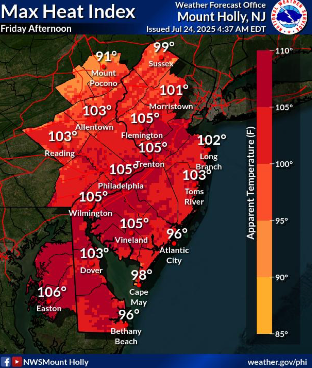
An extreme heat warning and heat advisory have been issued for all of southeastern Pennsylvania from 10 a.m. to 9 p.m. on Friday.
As has been the case with storms in recent weeks, the only break in the deadly heat will come in the form of thunderstorms.
Find out what's happening in Across Pennsylvaniafor free with the latest updates from Patch.
Friday's storms are likely to begin after 2 p.m., with the greatest threat coming before 8 p.m., according to forecasters.
Scattered severe thunderstorms could bring locally damaging wind gusts, which the National Weather Service has identified as the greatest threat from the storm.
Large hail, and "brief and heavy" downpours are also possible, forecasters said.
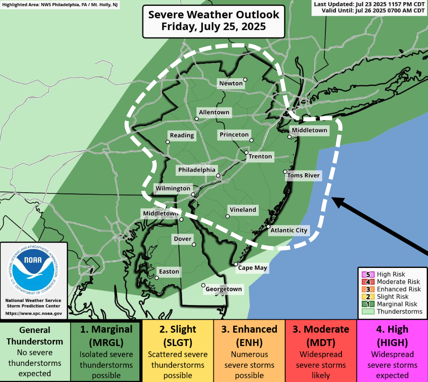
Additional rounds of thunderstorms are expected to strike on Saturday and Sunday as well, with storms focused on the afternoon and early evening hours, forecasters said.
Here's the full forecast for the coming days, according to the National Weather Service:
Thursday
Sunny, with a high near 89. Southwest wind 5 to 10 mph.
Thursday Night
Mostly clear, with a low around 74. Southwest wind 5 to 10 mph.
Friday
A chance of showers and thunderstorms after 2 p.m. Mostly sunny, with a high near 96. Heat index values as high as 105. West wind 5 to 10 mph. Chance of precipitation is 30 percent. New rainfall amounts of less than a tenth of an inch, except higher amounts possible in thunderstorms.
Friday Night
A chance of showers and thunderstorms before 8 p.m. Partly cloudy, with a low around 77. North wind around 5 mph. Chance of precipitation is 30 percent. New precipitation amounts of less than a tenth of an inch, except higher amounts possible in thunderstorms.
Saturday
Partly sunny, with a high near 90. Northeast wind around 5 mph becoming east in the afternoon.
Saturday Night
A chance of showers and thunderstorms after 2 a.m. Mostly cloudy, with a low around 72. Chance of precipitation is 30 percent.
Sunday
A chance of showers, with thunderstorms also possible after 2 p.m. Partly sunny, with a high near 91. Chance of precipitation is 50 percent.
Sunday Night
A chance of thunderstorms before 8 p.m. Partly cloudy, with a low around 74. Chance of precipitation is 30 percent.
Get more local news delivered straight to your inbox. Sign up for free Patch newsletters and alerts.