Weather
Tornado Watch Issued In Philly Area Monday
An "especially intense tornado" is possibile, forecasters said, with potential 80 mph wind gusts that could close roads and cancel flights.

A tornado watch has been issued for the greater Philadelphia area Monday as storms capable of inflicting significant damage move into the area this afternoon.
The watch is in place for the entire five-county region, as well as all of South Jersey, until 7 p.m. It indicates that "a few tornadoes are likely," and warns of widespread wind gusts up to 80 miles per hour. There could also be quarter-sized hail.
During a tornado watch, residents are urged to remain vigilant, keep track of conditions outside, and monitor the National Weather Service's routine updates on the storm for the latest details on its approach.
Find out what's happening in Across Pennsylvaniafor free with the latest updates from Patch.
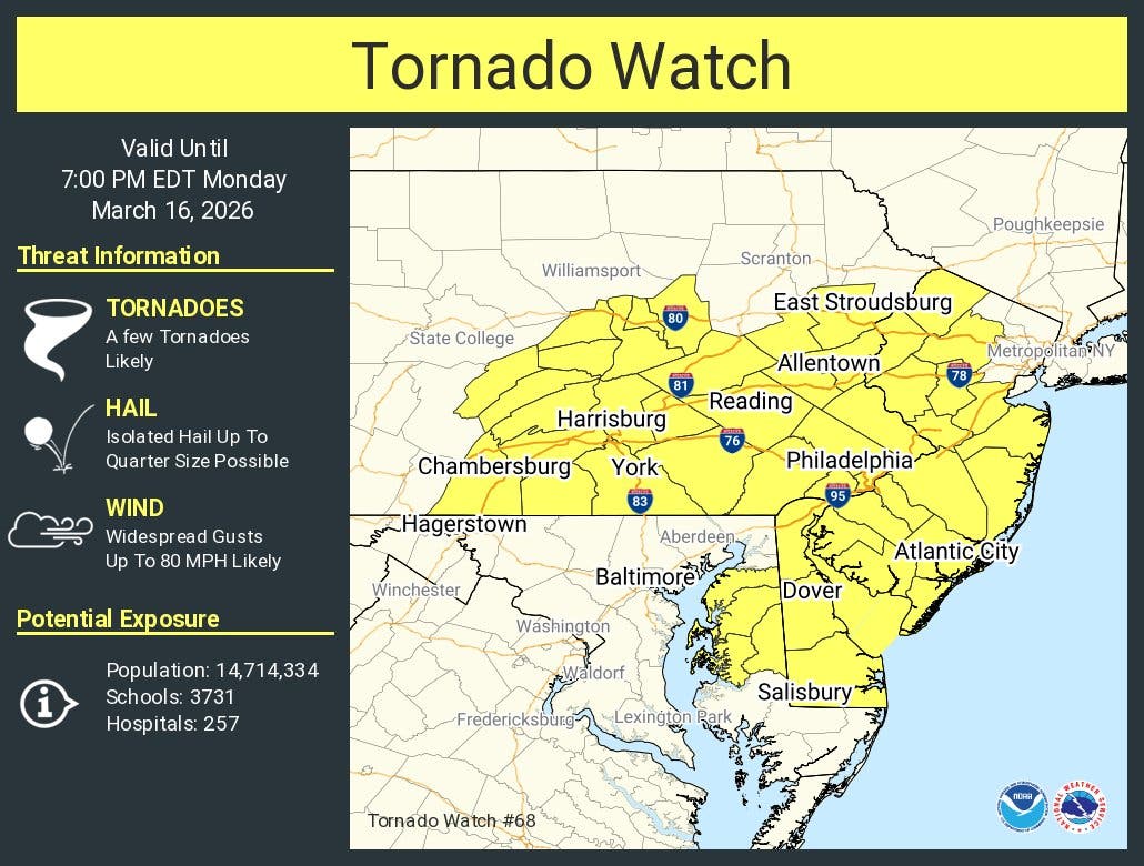
Severe thunderstorms and the potential tornadoes could bring down trees and wires and cause widespread power outages, according to authorities. Accuweather warned of the potential for canceled flights at Philadelphia International Airport as well as closed roads impacting traffic.
Storms will arrive at around 2 p.m. and slowly intensify as the afternoon wears on, with the peak of their strength from 5 p.m. to 11 p.m., forecasters said.
Find out what's happening in Across Pennsylvaniafor free with the latest updates from Patch.
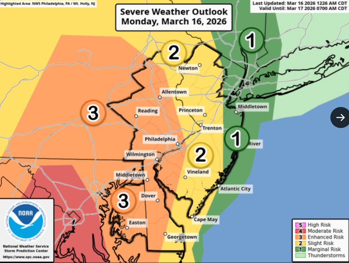
The National Weather Service characterized the front as "significant," and rated it more severe than thunderstorms that have hit the area within the last two weeks. The Philadelphia region is within the agency's Level 3 "enhanced risk" zone for the storm.
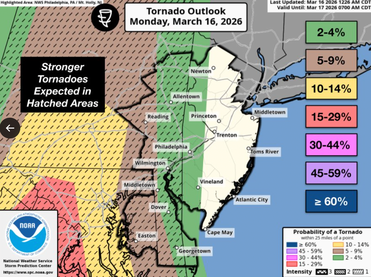
Wind gusts could hit up to 80 miles her hour, Accuweather added. There is anywhere from a 5 to a 14 percent chance of a tornado, the National Weather Service said.
"A few tornadoes, including the possibility of an especially intense tornado, cannot be ruled out," Accuweather Chief Meteorologist Jon Porter said.
Here is the full forecast for the coming week, according to the National Weather Service:
Monday
Showers and thunderstorms likely, then showers and possibly a thunderstorm after 1 p.m. Some of the storms could be severe and produce heavy rainfall. High near 69. Breezy, with a south wind 15 to 20 mph, with gusts as high as 40 mph. Chance of precipitation is 90 percent. New rainfall amounts between a tenth and quarter of an inch, except higher amounts possible in thunderstorms.
Monday Night
Showers and possibly a thunderstorm before 2 a.m., then a slight chance of showers between 2 a.m. and 3 a.m. Some of the storms could be severe and produce heavy rainfall. Low around 32. Breezy, with a south wind 15 to 20 mph becoming west after midnight. Winds could gust as high as 45 mph. Chance of precipitation is 100 percent. New precipitation amounts between a half and three quarters of an inch possible.
Tuesday
Mostly sunny, with a high near 42. Breezy, with a west wind 15 to 20 mph, with gusts as high as 30 mph.
Tuesday Night
Mostly clear, with a low around 26. West wind 5 to 15 mph, with gusts as high as 25 mph. Wednesday Partly sunny, with a high near 41. Calm wind becoming south around 5 mph in the afternoon.
Wednesday Night
Mostly cloudy, with a low around 29.
Thursday
Partly sunny, with a high near 50.
Thursday Night
Mostly cloudy, with a low around 37.
Friday
Mostly sunny, with a high near 59.
Friday Night
A chance of showers after 2 a.m. Mostly cloudy, with a low around 40. Chance of precipitation is 30 percent.
Saturday
A chance of showers. Mostly cloudy, with a high near 57. Chance of precipitation is 30 percent.
Saturday Night
A chance of showers. Mostly cloudy, with a low around 39. Chance of precipitation is 30%.
Get more local news delivered straight to your inbox. Sign up for free Patch newsletters and alerts.