Weather
Flooding, 7 Inches Of Rain, Damaging Winds In PA Thursday: Forecasters
Widespread flooding is predicted as up to two inches of rain could fall per hour, the National Weather Service said.


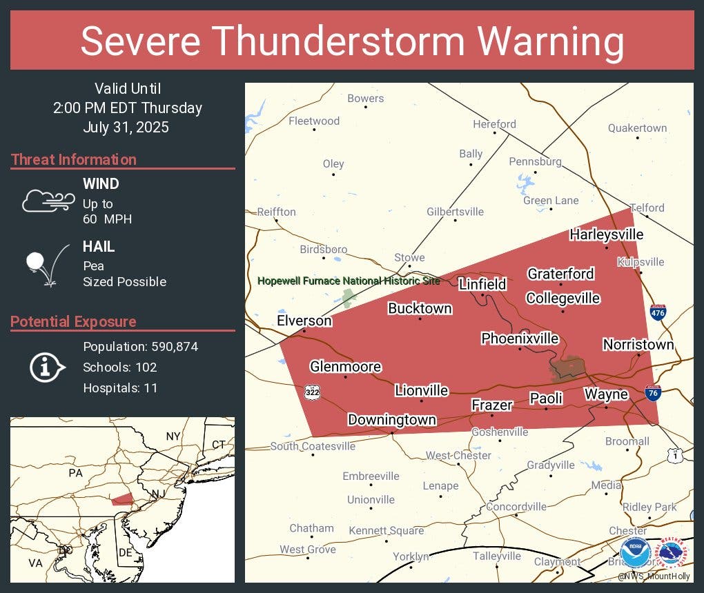
A severe thunderstorm warning has been issued in parts of southeastern Pennsylvania Tuesday afternoon until 2 p.m. The warning covers a swath of Montgomery and Chester counties.
A flash flood warning was also issued for much of the region until 5:30 p.m.
Original story:
Find out what's happening in Across Pennsylvaniafor free with the latest updates from Patch.
Powerful storms will hit the greater Philadelphia area on Thursday night, bringing up to 7 inches of rain in the most inundated areas, "significant" flooding, thunderstorms, and damaging winds, the National Weather Service said.
Storms are likely move in during the early afternoon, possibly by around 2 p.m., the National Weather Service said. A flood watch has been declared from 2 p.m. Thursday to 6 a.m. Friday.
Find out what's happening in Across Pennsylvaniafor free with the latest updates from Patch.
"Isolated wind damage is possible early," the National Weather Service's Mt. Holly, New Jersey branch said. "We are becoming increasingly concerned about flash flooding potential with this activity, particularly across the moderate risk area."
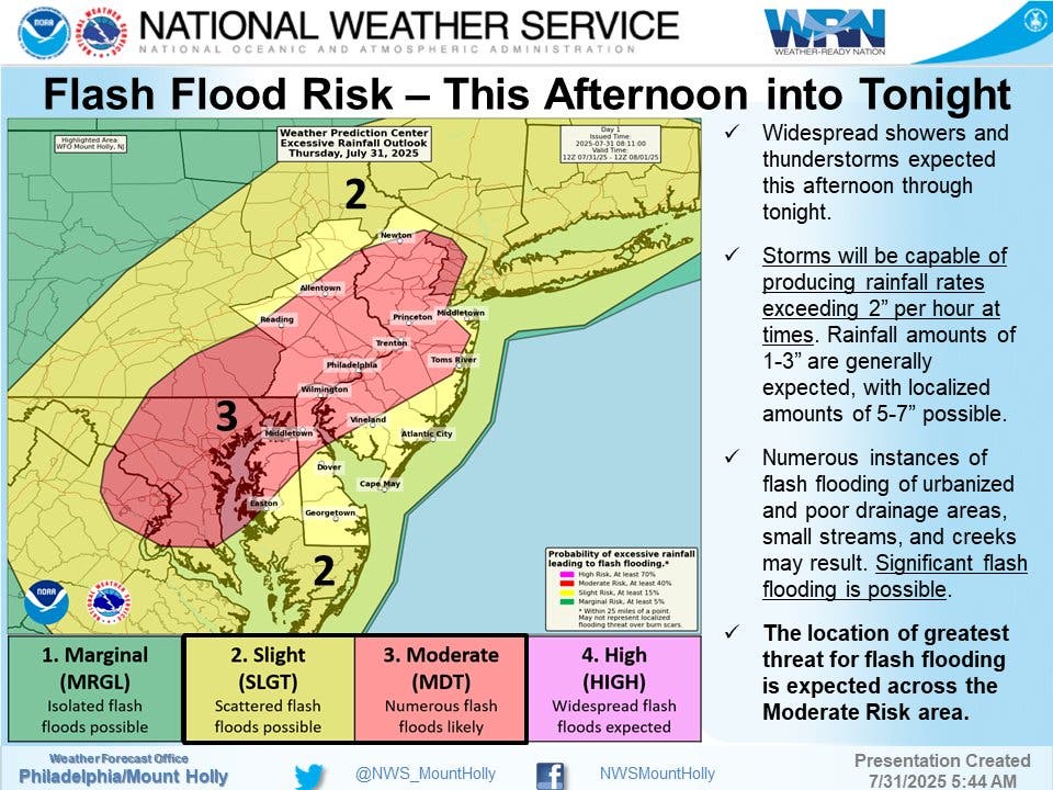
All of southeastern Pennsylvania falls within the National Weather Service's moderate risk area, and unlike other storm fronts that have threatened in recent days, Thursday's front is predicted to be "widespread."
Rain could fall at a rate of 2 inches per hour, with widespread totals of at least 1 to 3 inches expected, and as much as 5 to 7 inches possible in the hardest hit areas, forecasters said. That will be more than enough to cause flooding, potentially severe.
"Flooding could result in road closures," the National Weather Service warned. "Significant flash flooding is possible."
"Major travel disruptions are possible within 100 miles of I-95, especially into the first part of Thursday night," Accuweather added. "In some cases, an inch of rain can pour down in 15-30 minutes. As the rainfall continues at varying intensities, problems will arise."

Small streams, creeks, poor drainage areas, and urban areas with lack of permeable surfaces are all at heightened risk.
Winds could also be strong enough to bring down trees and electrical wires, creating hazards on the road and in flooded areas as well as knocking out power across the region, forecasters said.
Drivers should try to avoid the roads if possible during the height of the storm, and should always turn around if confronted with standing water.
Here's the full forecast for the next several days, according to the National Weather Service:
Thursday
Showers and thunderstorms likely, then showers and possibly a thunderstorm after 5pm. Some of the storms could produce heavy rainfall. High near 90. Southeast wind 5 to 10 mph. Chance of precipitation is 80 percent. New rainfall amounts between a half and three quarters of an inch possible.
Thursday Night
Showers and thunderstorms before 5 a.m., then showers likely. Some of the storms could produce heavy rainfall. Low around 66. Northeast wind 5 to 10 mph. Chance of precipitation is 90%. New rainfall amounts between three quarters and one inch possible.
Friday
A chance of showers. Mostly cloudy, with a high near 74. Northeast wind around 10 mph, with gusts as high as 25 mph. Chance of precipitation is 40 percent. New precipitation amounts of less than a tenth of an inch possible.
Friday Night
A slight chance of showers before 2 a.m. Partly cloudy, with a low around 63. Northeast wind 5 to 10 mph. Chance of precipitation is 20 percent.
Saturday
Sunny, with a high near 81. Northeast wind around 5 mph.
Saturday Night
Mostly clear, with a low around 61.
Sunday
Sunny, with a high near 84.
Sunday Night
Partly cloudy, with a low around 63.
Get more local news delivered straight to your inbox. Sign up for free Patch newsletters and alerts.