Weather
Potential ‘Super El Niño’ Coming Faster Than Expected: What It Means For PA
El Niño and its impacts on Pennsylvania are on an accelerated timeline, forecasters say.

Scientists are warning that conditions in the Pacific Ocean could lead to a powerful El Niño weather pattern that is developing earlier than expected, potentially bringing severe conditions in Pennsylvania that will continue into winter.
In a forecast discussion Thursday, the National Oceanic and Atmospheric Administration’s Climate Prediction Center estimated an 82 percent chance that El Niño conditions will develop as soon as this month and a 96 percent chance they will persist into February 2027.
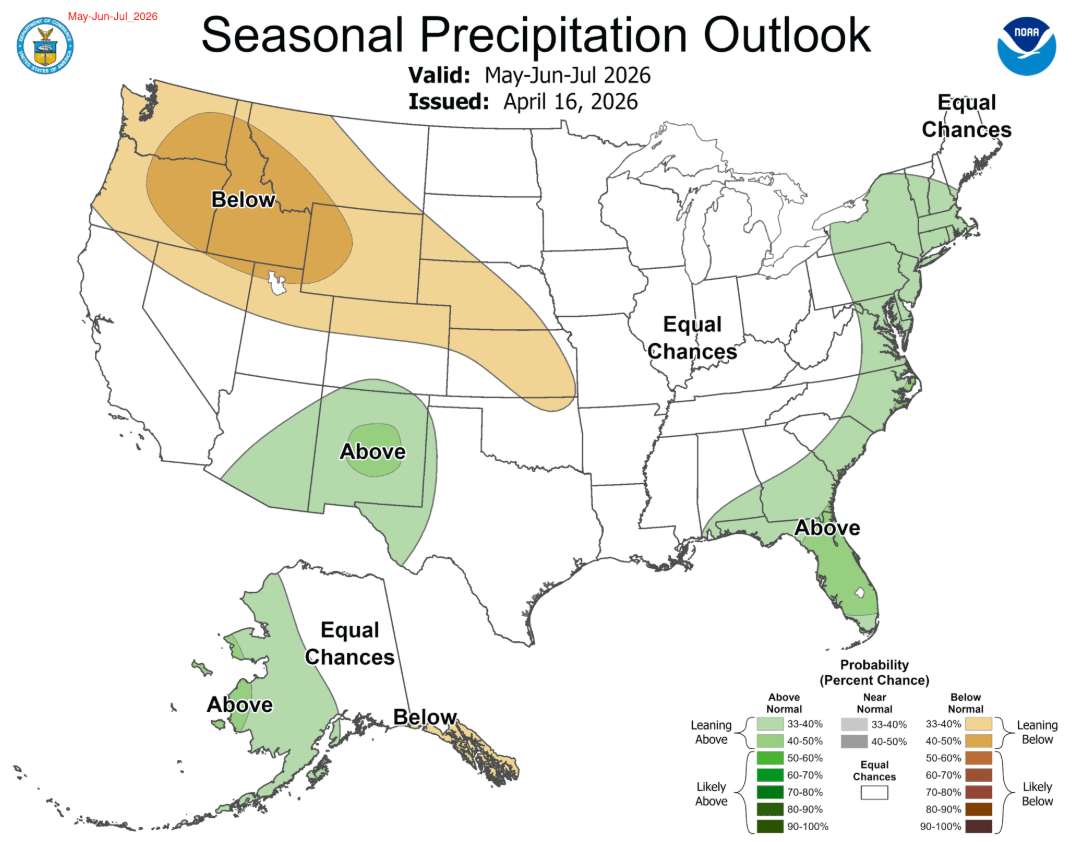
NOAA’s latest May through July outlook for Pennsylvania calls for an elevated, 50 to 60 percent above normal chance for higher temperatures. It's also calling for a 40 to 50 percent higher chance of elevated rainfall totals.
Find out what's happening in Across Pennsylvaniafor free with the latest updates from Patch.
A historically strong “super El Niño” can disrupt weather patterns worldwide, often bringing heavier rains and flooding to some regions while worsening drought and heat in others. Meteorologists say a major event in 2026 could contribute to record global temperatures, alter hurricane activity, fuel wildfires, and strain food and water supplies in vulnerable areas.
NOAA said it is still too early to know whether it will reach “super El Niño” strength. Spring forecasts are notoriously uncertain because ocean and atmospheric conditions can change rapidly.
Find out what's happening in Across Pennsylvaniafor free with the latest updates from Patch.
Thursday’s forecast discussion contrasts with a February outlook in which NOAA said a weakening La Niña in the tropical Pacific was expected to transition to ENSO-neutral conditions by spring, likely lasting through the summer.
AccuWeather, The Weather Channel and the Old Farmer’s Almanac also said in their February outlooks that a weakening La Niña pattern would transition to neutral conditions in the spring, but did not forecast a developing El Niño.
More recent forecasts, including one last month from the private weather company AccuWeather, said a strong El Niño was expected. The outlook for Pennsylvania includes temperature departures 1 to 2 degrees higher than the historical average, with an estimated 32 to 38 days over 90 degrees. Last year, when the region endured multiple heat waves, there were 37.
The historical average is 33.
July is likely to be the hottest month. Thunderstorms could bring localized flooding, but longer dry spells are also possible as storm tracks shift.
Related: El Niño Summer Forecast: How Hot And Stormy Will It Be In PA?
AccuWeather meteorologists said the Northeast and mid-Atlantic can expect a warmer summer with intense heat and potential localized flooding from thunderstorms. The South and Southeast may see frequent storms and above-average rain, while the Midwest and Ohio Valley face heat and severe, damaging storms. Hot, dry conditions in the West, particularly the Southwest, increase drought and wildfire risks.
Get more local news delivered straight to your inbox. Sign up for free Patch newsletters and alerts.