Weather
Flooding Threatens As 3 Days Of Stormy Weather Loom In Eastern PA
Don't be fooled by sunshine early Wednesday, as more rain and thunder are likely right around the corner, forecasters said.

EASTERN PA — Stormy weather will continue intermittently for the next several days in southeastern Pennsylvania, forecasters said, threatening parts of the region with flash flooding.
Most of Tuesday will actually be dry for the Philadelphia area, with sunny skies and a low chance of storm clouds breaking through until later in the evening.
Chances for rain and thunderstorms will steadily increase as the night goes on, with the best chance between 6 p.m. and midnight.
Find out what's happening in Across Pennsylvaniafor free with the latest updates from Patch.
By Wednesday morning storms will be likely in the city and surrounding suburbs, with up to a quarter inch of precipitation falling by the end of the evening, according to the National Weather Service.
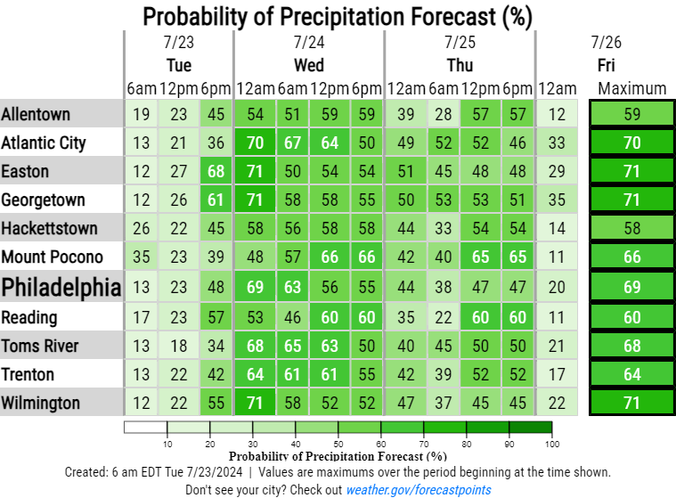
While Wednesday will mark the peak of storms, more rain and thunderstorms will be possible throughout the day and evening Thursday.
Find out what's happening in Across Pennsylvaniafor free with the latest updates from Patch.
Impacts like flooding remain possible throughout the region where higher amounts of rain fall within localized thunderstorms. Several consecutive days of potentially heavy rainfall puts the region at greater risk, forecasters said.
Here's the full forecast:
Tuesday
Isolated showers and thunderstorms after 1 p.m. Partly sunny, with a high near 90. West wind around 5 mph. Chance of precipitation is 20 percent.
Tonight
Scattered showers and thunderstorms, then showers likely and possibly a thunderstorm after midnight. Mostly cloudy, with a low around 73. South wind around 5 mph becoming calm in the evening. Chance of precipitation is 70 percent. New rainfall amounts between a tenth and quarter of an inch, except higher amounts possible in thunderstorms.
Wednesday
Showers likely and possibly a thunderstorm. Mostly cloudy, with a high near 86. Calm wind becoming southwest around 5 mph in the afternoon. Chance of precipitation is 60%. New rainfall amounts between a tenth and quarter of an inch, except higher amounts possible in thunderstorms.
Wednesday Night
A chance of showers and thunderstorms. Mostly cloudy, with a low around 74. South wind around 5 mph. Chance of precipitation is 40 percent. New rainfall amounts of less than a tenth of an inch, except higher amounts possible in thunderstorms.
Thursday
A chance of showers and thunderstorms. Mostly cloudy, with a high near 86. Southwest wind 5 to 10 mph. Chance of precipitation is 50 percent. New rainfall amounts of less than a tenth of an inch, except higher amounts possible in thunderstorms.
Thursday Night
A slight chance of showers and thunderstorms before 2 a.m. Mostly cloudy, with a low around 70. Chance of precipitation is 20%.
Friday
Sunny, with a high near 86.
Friday Night
Mostly clear, with a low around 67.
Get more local news delivered straight to your inbox. Sign up for free Patch newsletters and alerts.


