Weather
Latest Eastern PA Snow Total Predictions For Impending Winter Storm
For the first time in days, forecasters are speaking with confidence about what type of precipiation the Philadelphia area will receive.


EASTERN PA — Forecasters have issued their most confident prediction yet for the incoming winter storm this weekend, and it looks like the greater Philadelphia area may not be getting much snow, after all.
The storm, which has a chance to drop up to eight inches of snow in some parts of New Jersey and Pennsylvania, will likely be almost entirely rain in the southeastern part of the state.
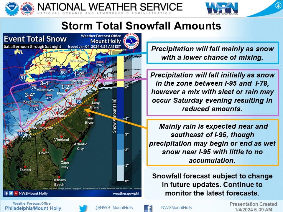
"A coastal system will bring widespread precipitation to our region," the National Weather Service's Mt. Holly, New Jersey station said early Thursday, adding that "The immediate urban corridor is unlikely to experience anything more than a wet coating of snow."
Find out what's happening in Across Pennsylvaniafor free with the latest updates from Patch.
Mostly rain is predicted in the area near and southeast of I-95, covering the city of Philadelphia and the immediate suburbs.
The more outlying suburbs may receive an inch or two of snow as the storm first hits, but a mix of sleet and rain will reduce any accumulation, the National Weather Service said.
Find out what's happening in Across Pennsylvaniafor free with the latest updates from Patch.
The update means that the Philly area will likely not see its much ballyhooed snow drought snap.
"The last time there was a snowstorm that brought at least an inch of snow to Philadelphia was on Jan. 28-29, 2022," Accuweather said. "However, this may not be the storm to snap the string in Philadelphia and areas farther to the southwest along I-95. The storm may still be struggling in strength as it passes through these areas and, combined with the warming effects of the Atlantic, could result in more rain than accumulating snow."
Still, the storm is forecasted to have an impact on the region, with heavy rain potentially causing mild flooding and hampering traffic. Roughly an inch of rain is expected throughout the area, with up to 1.5 inches possible in local areas where the storm hits heaviest.
"Rapid onset flooding," however, is unlikely, with the five-county Philly area having a less than five percent chance.
The storm is still on track to arrive early Saturday afternoon and continue through the evening before tapering off overnight or in the morning hours. Lingering rain is still possible in the morning Sunday.
Here is the latest forecast, according to the National Weather Service:
Thursday
Mostly sunny, with a high near 43. Northwest wind 5 to 15 mph.
Thursday night
Clear, with a low around 24. Northwest wind 5 to 10 mph.
Friday
Sunny, with a high near 38. Northwest wind 5 to 10 mph.
Friday night
Mostly cloudy, with a low around 28. Southwest wind around 5 mph becoming calm after midnight.
Saturday
Rain and snow, mainly after 1pm. High near 41. Light southeast wind becoming east 5 to 10 mph in the morning. Chance of precipitation is 90 percent. New snow accumulation of less than a half inch possible.
Saturday night
Rain and snow before 10pm, then rain between 10pm and 1am, then a chance of rain and snow after 1am. Low around 34. Breezy. Chance of precipitation is 100 percent. New precipitation amounts between a half and three quarters of an inch possible.
Sunday
A chance of rain, mixing with snow after 1pm, then gradually ending. Mostly cloudy, with a high near 39. Chance of precipitation is 50 percent.
Get more local news delivered straight to your inbox. Sign up for free Patch newsletters and alerts.


