Weather
Heavy Rain, Days Of Thunderstorms In Philly Area Weekend Forecast
Extreme heat Friday will give way to a barrage of storms this weekend that could cause flooding, forecasters said.

EASTERN PA — The region will be swathed in extreme heat Friday before severe thunderstorms and heavy rain move into the area over the weekend, forecasters said.
Storms are forecasted to arrive in the region by Friday afternoon, according to the National Weather Service.
The primary impact will be strong wind gusts that could be damaging where local thunderstorms hit.
Find out what's happening in Across Pennsylvaniafor free with the latest updates from Patch.
Heavy rain will arrive in the later afternoon or early evening. It's possible across all of southeastern Pennsylvania, but is most likely north and west and of the I-95 corridor, according to forecasters.
"Not everyone will see rain," the National Weather Service's Mt. Holly, New Jersey branch said, as the storm could have highly localized impacts. Still, the Weather Service urged local residents to be "weather aware" this weekend.
Find out what's happening in Across Pennsylvaniafor free with the latest updates from Patch.
Some flash flooding is possible late Friday due to torrential rain.
A second round of severe weather is most likely to hit Saturday afternoon or evening, with a diminishing chance into the evening, forecasters said. Up to an inch of rain is possible.
Rain and thunder will continue intermittently through Sunday evening until 11 p.m., though it is not forecasted to be as severe Saturday night.
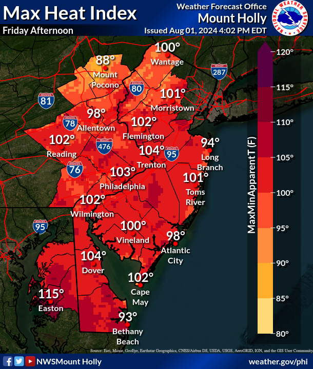
The storms will be preceded by extreme heat Friday, with heat indexes rising to 103 or 104 degrees is parts of the greater Philadelphia area.
Here's the full forecast:
Friday
Showers and thunderstorms likely, mainly after 5 p.m. Some of the storms could be severe. Partly sunny, with a high near 96. Heat index values as high as 103. South wind 5 to 10 mph. Chance of precipitation is 60 percent. New rainfall amounts between a quarter and half of an inch possible.
Friday Night
Showers and thunderstorms likely, mainly before 11 p.m. Some of the storms could be severe. Mostly cloudy, with a low around 75. Southwest wind around 5 mph becoming south in the evening. Chance of precipitation is 70 percent. New rainfall amounts between a quarter and half of an inch possible.
Saturday
A chance of showers and thunderstorms, mainly after 2 p.m. Mostly sunny, with a high near 90. Heat index values as high as 101. Southwest wind around 5 mph. Chance of precipitation is 40 percent. New rainfall amounts between a tenth and quarter of an inch, except higher amounts possible in thunderstorms.
Saturday Night
Showers likely and possibly a thunderstorm before 2 a.m, then a chance of showers and thunderstorms after 2 a.m. Mostly cloudy, with a low around 74. Southwest wind around 5 mph. Chance of precipitation is 70 percent. New rainfall amounts between three quarters and one inch possible.
Sunday
A chance of showers and thunderstorms, then showers likely and possibly a thunderstorm after 2 p.m. Partly sunny, with a high near 88. Southwest wind around 5 mph. Chance of precipitation is 60 percent. New rainfall amounts between a tenth and quarter of an inch, except higher amounts possible in thunderstorms.
Sunday Night
Showers and thunderstorms likely, mainly before 11 p.m. Partly cloudy, with a low around 73. Chance of precipitation is 60 percent. New rainfall amounts between a tenth and quarter of an inch, except higher amounts possible in thunderstorms.
Monday
Sunny, with a high near 92.
Monday Night
Mostly clear, with a low around 74.
Get more local news delivered straight to your inbox. Sign up for free Patch newsletters and alerts.