Weather
Another Winter Storm Headed To PA: See Latest Forecast
The greater Philadelphia area won't get much time to recover before another major precipitation event.

EASTERN PA — As the region recovers from a blast of winter weather over the weekend, another powerful storm is on already being tracked on the way to eastern Pennsylvania.
A flood watch has been issued for the region from Tuesday night through Wednesday night.
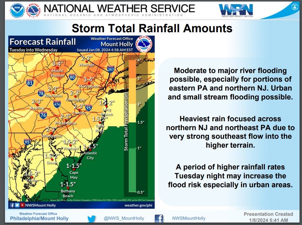
"This is likely to be quite an impactful event with significant flooding possible... both freshwater flooding due to heavy rains and coastal flooding due to very strong south/southeast winds late day Tuesday and Tuesday night," the National Weather Service's Mount Holly, New Jersey branch said.
Find out what's happening in Across Pennsylvaniafor free with the latest updates from Patch.
Wind gusts up to 45 miles per hour could slam the Philadelphia area.

The storm is expected to roll in during the latter part of Tuesday and continue into Wednesday. Heavy rain will fall, with 1 to 3 inches expected and up to 4 inches possible in some areas.
Find out what's happening in Across Pennsylvaniafor free with the latest updates from Patch.
After the recent storm, the ground and rivers will already be swollen, leading to moderate to major river flooding.
AccuWeather said residents across the nation can expect major travel disruptions "as the storm produces a vast area of snow, drenching rain, strong winds and even violent thunderstorms."
"In portions of the Northeast, where heavy snow from the storm the past weekend is on the ground, surging warm air, heavy rain and strong snow-eating winds will lead to a rapid runoff from Tuesday to Wednesday. Small streams and rivers will be on the rise with the potential for a serious flash flood event," according to AccuWeather.
Here's the full forecast:
Monday
Sunny, with a high near 42. Northwest wind around 5 mph.
Monday night
Increasing clouds, with a low around 30. Calm wind becoming east around 5 mph.
Tuesday
Rain, mainly after 10am. High near 53. East wind 5 to 10 mph increasing to 10 to 15 mph in the afternoon. Winds could gust as high as 30 mph. Chance of precipitation is 90%. New precipitation amounts between three quarters and one inch possible.
Tuesday night
Rain. The rain could be heavy at times. Low around 47. Windy, with a south wind 25 to 30 mph becoming southwest 20 to 25 mph after midnight. Winds could gust as high as 45 mph. Chance of precipitation is 100%. New precipitation amounts between 1 and 2 inches possible.
Wednesday
Rain likely before 7 a.m., then a slight chance of showers between 7 a.m. and 1 p.m. Partly sunny, with a high near 50. Breezy, with a southwest wind 15 to 25 mph, with gusts as high as 40 mph. Chance of precipitation is 60 percent. New precipitation amounts of less than a tenth of an inch possible.
Wednesday night
Mostly clear, with a low around 34. Breezy.
Get more local news delivered straight to your inbox. Sign up for free Patch newsletters and alerts.