Weather
More Storms In Eastern PA Forecast After Severe Flooding Hits Region: Latest Updates
A day after some parts of the region were inundated with torrential rainfall, another round of storms are poised to move through.

A second consecutive day of heavy rainfall will slam into the greater Philadelphia region Tuesday, bringing with it the danger of flash floods, according to forecasters. However, the risk of flooding is significantly lower than Monday, when various parts of Pennsylvania and New Jersey were inundated. A state of emergency was issued in New Jersey after many towns found their roadways and homes under water. Two people were killed in New Jersey after a vehicle was swept away at the height of the storm.
In Eastern Pennsylvania, isolated to scattered thunderstorms will arrive in the afternoon and continue through the evening, and could bring locally heavy rainfall.
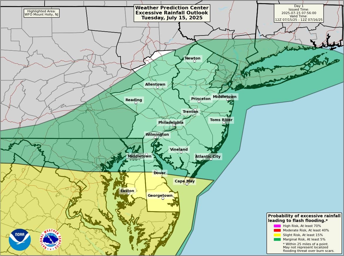
"While the threat of flash flooding is lower than Monday, any storms will be capable of producing brief heavy downpours again today," the National Weather Service's Mt. Holly, New Jersey branch said. "The greatest threat of flash flooding is across portions of Delmarva, where chances of storms are also greatest in our area."
Find out what's happening in Across Pennsylvaniafor free with the latest updates from Patch.
The greatest risk zone appears to be well south of the Philadelphia region, in central and southern Delaware and Maryland.
Monday's storm brought severe flooding to some areas of central New Jersey and Pennsylvania, including the Scranton area and around Lancaster County. In Mt. Joy, more than 7 inches of rain fell in a two hour period, swamping roadways and creating lethal conditions for drivers.
Find out what's happening in Across Pennsylvaniafor free with the latest updates from Patch.
In southeastern Pennsylvania, a flood warning was issued for parts of Montgomery County and Philadelphia that lasted until the early morning hours, but the most serious impacts were avoided.
According to the National Weather Service's rainfall reports, most of the five-county area received between 1 and 2 inches of rain throughout the entire storm Monday.
The chance of storms will persist throughout the week, with rain and thunderstorms likely throughout the afternoon and evening again on Wednesday and Friday.
Temperatures will remain elevated Tuesday, with a high of 87. The warmer it is, the more likely it is for severe, damaging rainfall and flooding, according to Accuweather.
"For every degree Celsius (about 2 degrees Fahrenheit) of warming, the atmosphere can hold roughly 7 percent more water vapor, giving storms more fuel for intense rainfall," Accuweather noted in an analysis of the historic floods that have ravaged the country this summer. "And as the overall global temperature increases, moisture-rich air that was once confined to the warm tropics can reach farther from the equator, bringing intense, tropical rainfall to more parts of the world."
Here's the full forecast, according to to the National Weather Service:
Tuesday
A slight chance of showers and thunderstorms before noon, then a chance of showers and thunderstorms after 1 p.m. Mostly sunny, with a high near 87. Calm wind becoming southwest around 5 mph. Chance of precipitation is 30 percent. New rainfall amounts of less than a tenth of an inch, except higher amounts possible in thunderstorms.
Tuesday Night
A chance of thunderstorms before 8 p.m., then a slight chance of showers after 4 a.m. Partly cloudy, with a low around 74. South wind around 5 mph becoming calm. Chance of precipitation is 30 percent. New precipitation amounts of less than a tenth of an inch, except higher amounts possible in thunderstorms.
Wednesday
A chance of showers before 11 a.m., then a chance of showers and thunderstorms between 11 a.m. and 2 p.m., then showers likely and possibly a thunderstorm after 2 p.m. Mostly cloudy, with a high near 89. Light southwest wind increasing to 5 to 10 mph in the morning. Chance of precipitation is 70 percent. New rainfall amounts between a tenth and quarter of an inch, except higher amounts possible in thunderstorms.
Wednesday Night
Showers likely and possibly a thunderstorm before 2am, then a chance of showers and thunderstorms between 2 a.m. and 5 a.m., then a chance of showers after 5 a.m. Mostly cloudy, with a low around 75. Southwest wind around 5 mph. Chance of precipitation is 60 percent. New rainfall amounts between a tenth and quarter of an inch, except higher amounts possible in thunderstorms.
Thursday
A chance of showers, with thunderstorms also possible after 8 a.m. Partly sunny, with a high near 91. Southwest wind 5 to 10 mph. Chance of precipitation is 50 percent. New rainfall amounts of less than a tenth of an inch, except higher amounts possible in thunderstorms.
Thursday Night
Partly cloudy, with a low around 77.
Friday
A chance of showers and thunderstorms after 2pm. Partly sunny, with a high near 91. Chance of precipitation is 50 percent.
Friday Night
A chance of showers and thunderstorms before 8 p.m. Mostly cloudy, with a low around 71. Chance of precipitation is 30 percent.
Get more local news delivered straight to your inbox. Sign up for free Patch newsletters and alerts.


