Weather
Heavy Rainfall Likely, Flood Watch Issued In Eastern PA: Full Forecast
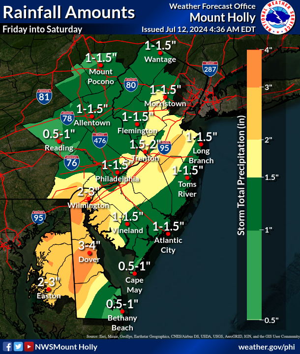
The rain may be torrential at times, with up to two inches per hour falling at the height of the storm.

EASTERN PA — Heavy rainfall could cause flooding throughout the greater Philadelphia area, forecasters said, bringing relief both to the ongoing heat wave and to semi-drought conditions that have persisted in parts of the region.
A flood watch is in place for the entire region from 2 a.m. Friday morning through 2 p.m. Saturday afternoon.
"Excessive runoff may result in flooding of rivers, creeks, streams, and other low-lying and flood-prone locations," the National Weather Service's Mt. Holly, New Jersey branch said. "Creeks and streams may rise out of their banks. Flooding may occurin poor drainage and urban areas. Low-water crossings may be flooded."
Find out what's happening in Across Pennsylvaniafor free with the latest updates from Patch.
The mixture of lingering tropical moisture and the storm front will bring rainfall that may be severe at times, and as much as two inches per hour are possible.
The general forecast for the area calls for about one to inches, but localized amounts of up to four inches "are possible," forecasters said.
Find out what's happening in Across Pennsylvaniafor free with the latest updates from Patch.
The severity of the rainfall will taper off Saturday afternoon, but the chance for rain and thunderstorms will continue through about 8 p.m. Saturday night before a clear and sunny day on Sunday.
The storm could make some roads impassable, and additional traffic and flight delays are possible.
The front will also drop the high temperature down to 84 on Friday and 87 on Saturday, with lows in the low 70s. Its a welcome taste of relief after multiple days with a heat index over 100 degrees.
"Abnormally dry to some isolated moderate drought conditions persist," the National Weather Service added, and coming rainfall will bring relief to the local ecosystem as well.
Here is the full forecast:
Friday
Showers and possibly a thunderstorm. Some of the storms could produce heavy rainfall. High near 84. Southeast wind around 5 mph becoming southwest in the afternoon. Chance of precipitation is 80 percent. New rainfall amounts between a quarter and half of an inch possible.
Friday Night
Showers and possibly a thunderstorm. Some of the storms could produce heavy rainfall. Patchy fog. Low around 74. South wind around 5 mph. Chance of precipitation is 90 percent. New rainfall amounts between a quarter and half of an inch possible.
Saturday
Showers and possibly a thunderstorm before 2 p.m, then a chance of showers and thunderstorms after 2 p.m. Patchy fog before 11 a.m. High near 87. Southwest wind around 5 mph. Chance of precipitation is 80 percent. New rainfall amounts between a quarter and half of an inch possible.
Saturday Night
A chance of showers before 8 p.m. Patchy fog after 11 p.m. Otherwise, partly cloudy, with a low around 74. South wind around 5 mph becoming calm. Chance of precipitation is 30 percent. New precipitation amounts of less than a tenth of an inch possible.
Sunday
Sunny, with a high near 94. Calm wind becoming west around 5 mph in the afternoon.
Sunday Night
Mostly clear, with a low around 75.
Monday
Sunny and hot, with a high near 97.
Monday Night
Mostly clear, with a low around 76.
Tuesday
Sunny and hot, with a high near 98.
Tuesday Night
A chance of showers and thunderstorms between 8 p.m and 2 a.m. Partly cloudy, with a low around 78. Chance of precipitation is 30 percent.
Wednesday
A chance of showers and thunderstorms. Mostly sunny, with a high near 95. Chance of precipitation is 40 percent.
Wednesday Night
A chance of showers and thunderstorms. Mostly cloudy, with a low around 72. Chance of precipitation is 50 percent.
Thursday
A chance of showers and thunderstorms. Partly sunny, with a high near 85. Chance of precipitation is 40 percent.
Get more local news delivered straight to your inbox. Sign up for free Patch newsletters and alerts.


