Weather
Latest Timeline For Snow As Winter Weather Advisory Issued In PA
A winter storm is on the way to the greater Philadelphia area this week.

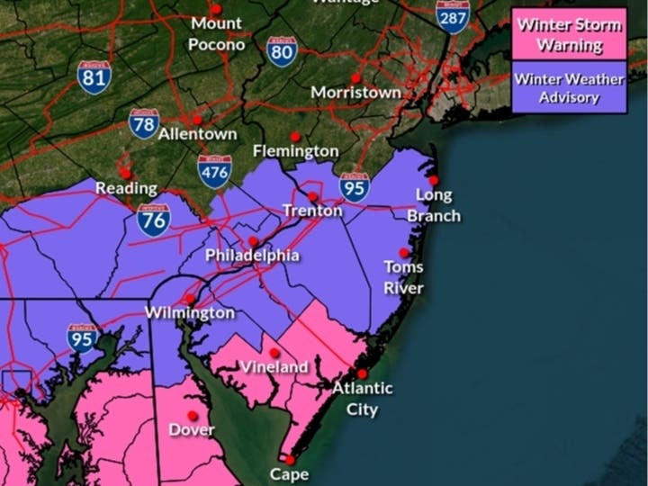
Moderate to heavy snow will blanket much of the greater Philadelphia region Tuesday night into Wednesday morning, bringing potentially significant impacts to commuters.
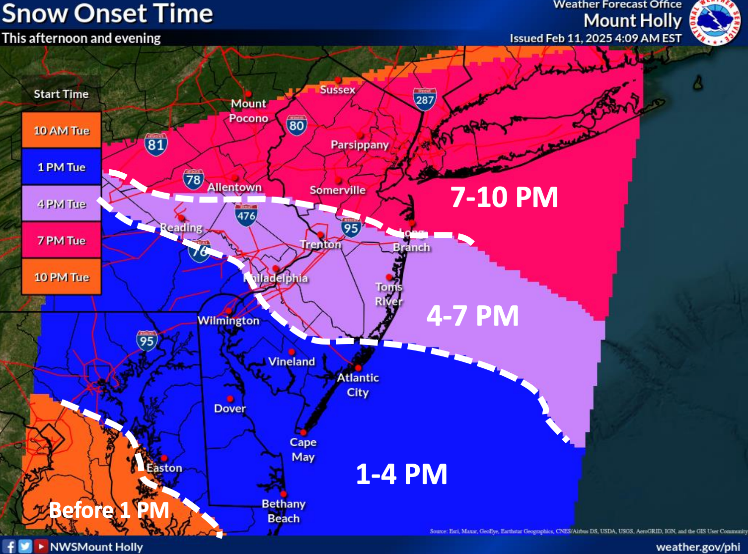
There is a wide window for exactly when the storm will begin. Forecasts estimate the weather could make its arrival in Philadelphia and most of the immediate suburbs between 4 and 7 p.m. Some areas further west and south into Delaware could see impacts beginning as early as 1 p.m.
Most of the region is forecasted for about 3 to 4 inches of snow accumulation from late Tuesday to early Wednesday, with the heaviest snow falling between 7 p.m. and midnight.
Find out what's happening in Across Pennsylvaniafor free with the latest updates from Patch.
Snow could fall at a rate of up to an inch an hour, forecasters said.
"Widespread light to moderate accumulating snow could create hazardous driving conditions," the National Weather Service's Mt. Holly, New Jersey branch said in its latest briefing Tuesday morning. "The snow will impact this evening’s and/or Wednesday morning commutes."
Find out what's happening in Across Pennsylvaniafor free with the latest updates from Patch.
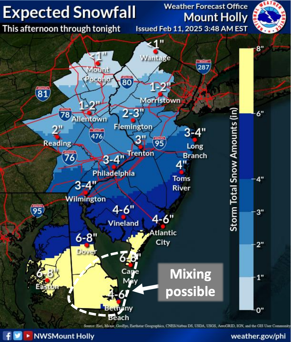
Deeper south Jersey is currently forecasted to receive the brunt of the storm, with closer to six inches predicted there.
The storm will bring a second burst to the region later Wednesday into Thursday morning, although it is still unclear if this will fall as rain or snow.
The current forecast calls for most accumulating snow to fall north and west of the five county area. Additional accumulation for this second round ranges from less than an inch in the Trenton area, to up to two inches in Allentown and parts of the Lehigh Valley.
Most of southeastern Pennsylvania is predicted to receive rain during this second round of the storm, but that could still change to snow, forecasters warn. It depends on the movement of a warm front into the area.
Precipitation will fall from later Wednesday night, and should be fully moved out from the region by 1 p.m. Thursday.
Here's the full forecast, according to the National Weather Service:
Tuesday: A chance of snow after 3 p.m. Cloudy, with a high near 36. Calm wind becoming southwest around 5 mph in the afternoon. Chance of precipitation is 40 percent. Total daytime snow accumulation of less than a half inch possible.
Tuesday night: Snow, mainly before 3 a.m. Low around 29. Calm wind becoming northeast around 5 mph after midnight. Chance of precipitation is 90 percent. New snow accumulation of 2 to 4 inches possible.
Wednesday: A slight chance of snow before 10 a.m., then a chance of rain and snow between 10am and 4 p.m., then a chance of rain after 4 p.m. Cloudy, with a high near 37. Northeast wind 5 to 10 mph. Chance of precipitation is 40 percent. New snow accumulation of less than a half inch possible.
Wednesday night: Rain. Low around 34. East wind 5 to 10 mph. Chance of precipitation is 100 percent. New precipitation amounts between a quarter and half of an inch possible.
Thursday: A chance of rain before 1 p.m. Mostly cloudy, with a high near 49. East wind 5 to 10 mph becoming west in the afternoon. Chance of precipitation is 50 percent. New precipitation amounts of less than a tenth of an inch possible.
Thursday night: Partly cloudy, with a low around 27.
Friday; Sunny, with a high near 37.
Friday night: Mostly cloudy, with a low around 27.
Get more local news delivered straight to your inbox. Sign up for free Patch newsletters and alerts.


