Weather
Major Shift In Weather Pattern Coming To Philly Area: Forecasters
Highs in the mid-80s, rain, thunderstorms, and more with a chaotic week on tap. Details:

Weather chaos will continue in southeastern Pennsylvania to close out March and enter April, with thunderstorms on the horizon and at least some rain possible every day for the coming week. It's part of what the National Weather Service calls a continuing "unsettled pattern."
The week will start mild and windy, with gusts up to 25 miles per hour Monday. Thunder could arrive as early as Monday night, with a possibility of storms after 2 a.m.
Thunder remains in the forecast into Tuesday morning, which will give way to sharply rising temperatures. The predicted high Tuesday is 80, while Wednesday could get up to 83.
Find out what's happening in Across Pennsylvaniafor free with the latest updates from Patch.
The strongest storms and best chance for thunderstorms appear to be Wednesday, with steady showers likely throughout the afternoon and thunderstorms possible in the evening hours.
"A warming trend will prevail through mid-week as a warm front lifts northward across the region, though clouds and spotty showers will accompany the front," the National Weather Service's Mt. Holly, New Jersey branch shared. "A cold front comes through on Wednesday night, bringing some showers and thunderstorms in the afternoon and
evening ahead of the front."
Find out what's happening in Across Pennsylvaniafor free with the latest updates from Patch.
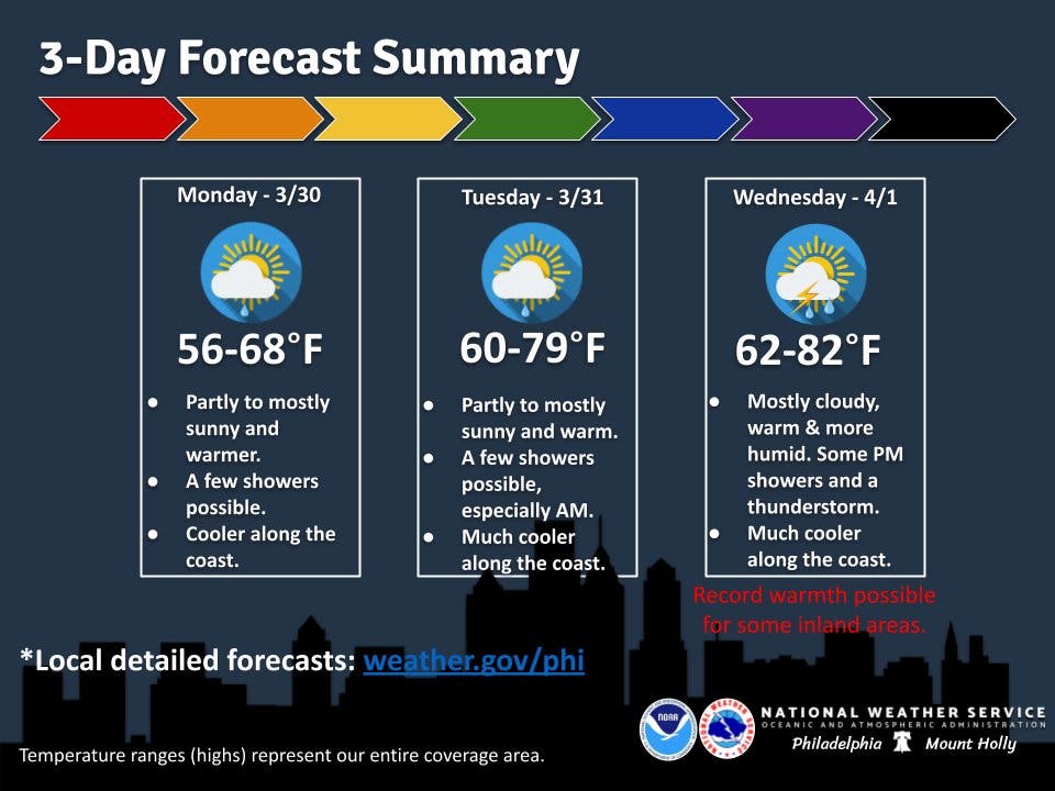
Temperatures will sharply plummet Thursday as cool air hits the region, with a possible drastic temperature shift from Wednesday's mid-80s down to Thursday night's high 40s, the forecast shows.
A chance of rain remains in the forecast every day through the weekend. Clarity on the chances of precipitation is likely in the coming days.
Here's the full forecast for the Philadelphia area for the coming, according to the National Weather Service:
Monday
Isolated showers after 3 p.m. Increasing clouds, with a high near 66. Southwest wind 10 to 15 mph, with gusts as high as 25 mph. Chance of precipitation is 20 percent.
Monday Night
Scattered showers, with thunderstorms also possible after 2 a.m. Mostly cloudy, with a low around 58. Southwest wind 5 to 10 mph. Chance of precipitation is 40 percent. New rainfall amounts of less than a tenth of an inch, except higher amounts possible in thunderstorms.
Tuesday
A slight chance of showers and thunderstorms before 8 a.m., then isolated showers between 8 a.m. and 2 p.m. Partly sunny, with a high near 80. Southwest wind 10 to 15 mph. Chance of precipitation is 20 percent.
Tuesday Night
Mostly cloudy, with a low around 65. Southwest wind 10 to 15 mph, with gusts as high as 25 mph.
Wednesday
Showers likely, mainly after 2 p.m. Partly sunny, with a high near 83. Chance of precipitation is 70 percent. New precipitation amounts of less than a tenth of an inch possible.
Wednesday Night
Showers likely and possibly a thunderstorm before 8 p.m., then rain likely and possibly a thunderstorm between 8 p.m. and 2 a.m., then a chance of rain after 2 a.m. Mostly cloudy, with a low around 54. Chance of precipitation is 70 percent.
Thursday
A chance of rain. Mostly cloudy, with a high near 63. Chance of precipitation is 40 percent.
Thursday Night
A chance of rain. Mostly cloudy, with a low around 49. Chance of precipitation is 50 percent.
Friday
A chance of rain. Mostly cloudy, with a high near 66. Chance of precipitation is 40 percent.
Friday Night
A chance of rain. Mostly cloudy, with a low around 51. Chance of precipitation is 50 percent.
Saturday
A chance of rain. Mostly cloudy, with a high near 65. Chance of precipitation is 40 percent.
Saturday Night
A chance of rain. Mostly cloudy, with a low around 48. Chance of precipitation is 50 percent.
Sunday
A chance of rain. Mostly cloudy, with a high near 71. Chance of precipitation is 50 percent.
Get more local news delivered straight to your inbox. Sign up for free Patch newsletters and alerts.